West Linton
|
West Linton Scottish Gaelic Liontan Ruairidh |
||
|---|---|---|
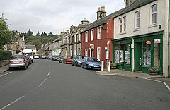
| Street train in West Linton | ||
| Coordinates | 55 ° 45 ′ N , 3 ° 21 ′ W | |
|
|
||
| Residents | 1547 2011 census | |
| administration | ||
| Post town | WEST LINTON | |
| ZIP code section | EH46 | |
| prefix | 01968 | |
| Part of the country | Scotland | |
| Council area | Scottish Borders | |
| British Parliament | Dumfriesshire, Clydesdale and Tweeddale | |
| Scottish Parliament | Midlothian South, Tweeddale and Lauderdale | |
West Linton , in Gaelic Liontan Ruairidh , is a village on the north-west edge of the Scottish Council Area Scottish Borders or in the traditional county of Peeblesshire . It is located about eleven kilometers southwest of Penicuik and twelve kilometers northwest of Peebles off the eastern flank of the Pentland Hills . The Lyne Water flows through West Linton .
history
Until the 12th century, West Linton was called Lyntoun Roderyck . It was first renamed Lintoun and eventually West Linton in the 19th century . It is one of the oldest known market towns in Scotland and was particularly known for its sheep markets. Bernard de Linton , Abbot of Arbroath Monastery and Lord Chancellor of Scotland , the presumed author of the Arbroath Declaration , is from West Linton. In the 17th century, silver and lead were mined in the area. Stonemasonry was also promoted under Laird John Gifford . In the irregularly designed old town there are numerous stone carvings, especially from the 18th and 19th centuries. The Gifford's Stone House is well known .
John Stewart, 1st Earl of Traquair installed West Linton as the Burgh of Regality for a short time . At that time it was a regional transport hub and was in close contact with the Lords of Dalkeith House .
After a maximum of 514 people were counted in West Linton in the course of the 19th century, the number had risen to 667 by 1961. Since then, the number of inhabitants has increased steadily. As part of the 2011 census survey, West Linton had 1,547 residents.
traffic
In the West, from happening Edinburgh to St John's Town of Dalry leading A702 West Linton and includes the town on to the trunk road network. A few kilometers to the east there is a connection to the A701 (Edinburgh– Dumfries ). In the 1860s, West Linton received a station, at times called Broomlee , along the Leadburn, Linton and Dolphinton Railway , a branch line of the Peebles Railway between Edinburgh and Peebles. In the 1930s, however, the route was abandoned.
Individual evidence
- ^ List of Gaelic expressions
- ↑ a b Entry in the Gazetteer for Scotland
- ↑ Listed Building - Entry . In: Historic Scotland .
- ^ Linton in: FH Groome (ed.): Ordnance Gazetteer of Scotland: A Survey of Scottish Topography, Statistical, Biographical and Historical , Grange Publishing Works, Edinburgh, 1882-1885.
- ^ Information in the Gazetteer of Scotland
- ↑ 2011 census
- ↑ Information on the Leadburn, Linton and Dolphinton Railway

