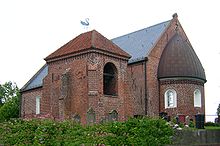
Westeraccum
|
Westeraccum
Dornum municipality
|
||
|---|---|---|
| Coordinates: 53 ° 38 ′ 59 ″ N , 7 ° 26 ′ 40 ″ E | ||
| Height : | 4 (1–4) m above sea level NN | |
| Residents : | 398 (2015) | |
| Incorporation : | July 1, 1972 | |
| Postal code : | 26553 | |
| Area code : | 04933 | |
|
Location of Westeraccum in Lower Saxony |
||
Westeraccum is a district of the municipality of Dornum in East Frisia . In 2008 the district had 405 inhabitants.
Surname
Westeraccum was first mentioned in the early 12th century as "Westrachem". Later names were "Westeragheim, Westerachem" (around 1200) and "Wester Accum" (1684). It is a combination of the nickname Acke with home and indication of the compass direction. The form wester instead of west, which occurs frequently in northern Germany, goes back to the old Frisian adjective wester ( west ).
Geographical location
Westeraccum was founded as a warf village on a Geest island, which is surrounded by Kalkmarsch .
history
The place is first mentioned in the early 12th century as Westrachem . Around 1200 it was called Westeragheim . The current spelling has been used since the 17th century. The place name is a combination of the nickname Acke with -Sum, which means home, and the direction west. Westeraccum is thus to be interpreted as a place west of Ehe (small river).
On July 1, 1972, Westeraccum, until then located in the Wittmund district, was incorporated into the Dornum district.
coat of arms
Since 2004 the place has had a coat of arms on the initiative of the Heimatverein Westeraccum eV. It shows in gold (yellow) a bricked black bridge over a blue water shield river. Above in front a swimming blue swan and behind a blue millstone. It symbolizes the history of the place: the colors blue and gold document the earlier affiliation of Westeraccum to the Harlingerland . Black and gold, on the other hand, represent the current affiliation to Dornum in the Norderland . The base of the corrugated shield symbolizes the Accumer Ee river, over which a stone bridge led in the village. It was the historical border between the Harlingerland and the Norderland and provided with a barrier. The swan (Luther swan) stands for the historic St. Petri fisherman's church , the millstone for the old Accumer windmill.
Web links
Individual evidence
- ^ Municipality of Dornum: Numbers / data / facts - origin of the municipality , accessed on August 11, 2010.
- ↑ Municipality of Dornum: Brief information on the municipality of Dornum , accessed on August 11, 2010.
- ^ Ortschronisten der Ostfriesischen Landschaft: Westeraccum, Samtgemeinde Dornum, Landkreis Aurich (PDF; 668 kB), accessed on August 11, 2010.
- ^ Federal Statistical Office (ed.): Historical municipality directory for the Federal Republic of Germany. Name, border and key number changes in municipalities, counties and administrative districts from May 27, 1970 to December 31, 1982 . W. Kohlhammer GmbH, Stuttgart / Mainz 1983, ISBN 3-17-003263-1 , p. 264 .
- ^ Municipality of Dornum: Westeraccum coat of arms , accessed on August 11, 2010.


