Westerbur
|
Westerbur
Dornum municipality
|
||
|---|---|---|
| Coordinates: 53 ° 39 ′ 29 ″ N , 7 ° 29 ′ 40 ″ E | ||
| Height : | 3 (1–4) m above sea level NN | |
| Residents : | 279 (2015) | |
| Incorporation : | July 1, 1972 | |
| Incorporated into: | Dornum | |
| Postal code : | 26553 | |
| Area code : | 04933 | |
|
Location of Westerbur in Lower Saxony |
||
|
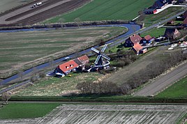
Westerbur (2013)
|
||
Westerbur is a district of the municipality Dornum in East Frisia . In 2008 the district, to which Middelsbur also belongs, had 279 inhabitants.
Westerbur is about one and a half kilometers south of the North Sea coast. The main town of the municipality, Dornum, is about three kilometers away in a west-southwest direction. The neighboring village of Dornumersiel joins two kilometers to the northwest .
history
The place was founded as a Warfendorf, which is surrounded by Kalkmarsch . The place was first mentioned in a document possibly in the 8th or 9th century as Westerbure . In 1530 he was called Westerbuhr . The current spelling has been used since 1589. The place name is a combination of the direction West- with -Bur, which means peasantry.
On July 1, 1972, Westerbur was incorporated into the municipality of Dornumersiel. On November 1, 2001 this came to the Dornum community.
Affiliations:
- Since November 1, 2001: Dornum municipality
- July 1, 1972 - October 31, 2001: Dornumersiel municipality
- July 1, 1972 - October 31, 2001: Samtgemeinde Dornum
- Until June 30, 1972: Westerbur municipality
- Since 1977: District of Aurich
- 1972 - 1977: North district
- Until 1972: Wittmund district
- 1978 - December 31, 2004: Weser-Ems administrative region
- Until 1978: District of Aurich
- Since November 1, 1946: State of Lower Saxony
- 1885 - November 1, 1946: State of Hanover
- Since May 24, 1949: Federal Republic of Germany
- 1945 to May 22, 1949: British zone of occupation
- 1866 - August 23, 1946: Free State of Prussia
- 1871 - 1945: German Empire
Attractions
The Westerbur Church , built in 1753 on the foundations of the previous medieval church .
Web links
Individual evidence
- ^ Municipality of Dornum: Brief information on the municipality of Dornum , accessed on August 14, 2018.
- ^ Ortschronisten der Ostfriesischen Landschaft: Westerbur, Samtgemeinde Dornum, Landkreis Aurich (PDF file; 453 kB), accessed on September 3, 2012.
- ^ Federal Statistical Office (ed.): Historical municipality directory for the Federal Republic of Germany. Name, border and key number changes in municipalities, counties and administrative districts from May 27, 1970 to December 31, 1982 . W. Kohlhammer GmbH, Stuttgart / Mainz 1983, ISBN 3-17-003263-1 , p. 264 .
- ↑ StBA: Changes in the municipalities in Germany, see 2001


