Whitianga
| Whitianga | ||
| Geographical location | ||
|
|
||
| Coordinates | 36 ° 50 ′ S , 175 ° 42 ′ E | |
| Region ISO | NZ-WKO | |
| Country |
|
|
| region | Waikato | |
| District | Thames-Coromandel District | |
| Ward | Mercury Bay Ward | |
| Residents | 4th 368 (2013) | |
| height | 2 m | |
| Post Code | 3510 | |
| Telephone code | +64 (0) 7 | |
| UN / LOCODE | NZ WTZ | |
| Photography of the place | ||
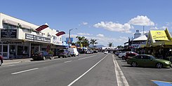
 Albert Street in Whitianga |
||
Whitianga is a town in the Thames-Coromandel District of the Waikato regionon the North Island of New Zealand .
Origin of name
The Māori -Legende after the Polynesian navigator and explorer should Kupe in the area around Whitianga be landed and the entrance to the natural harbor of Whitianga Harbor therefore Whitianga-a-Kupe have been called. In the Māori language , “ whitianga ” means something like passage or ford.
geography
The city is located around 38 km northeast of Thames , around 45 km north-northwest of Whangamata and around 19 km southeast of Coromandel , on the east coast of the Coromandel Peninsula . Whitianga is enclosed on two sides by Whitianga Harbor , which borders the city from southwest to southeast and flows into Mercury Bay at its narrow point at Ferry Landing . Towards Mercury Bay , the city has a 3.7 km long sandy beach, Buffalo Beach , and a few kilometers to the west rise the mountain ranges of the Coromandel Range .
history
The area around Whitianga is said to have been settled around 950 AD by the tribesmen of Kupe , who gave the place the name " Te Whitianga a Kupe " . Other tribes in turn named the bay where they later settled after their leader, for example " Te Whanganui A Hei " (The great bay of Hei). When the British navigator and explorer Captain James Cook reached the bay in 1769, it was given the name " Mercury Bay ". From 1836, the first Europeans began to settle in the bay.
For decades, Whitianga was used as a port city for exporting timber to numerous countries, e. B. used in Norway , France or Italy . At that time, the place served as a center for processing flax and wood from kauri trees , building boats , mining and extracting rubber .
population
In the 2013 census, the town had 4,368 inhabitants, 15.9% more than in the 2006 census.
economy
Whitianga prefers to live from tourism and in parts also from farming.
Infrastructure
Road traffic
The New Zealand State Highway 25 passes northeast of the urban area and connects Whitianga with the northeastern part of the Coromandel Peninsula and with the town of Coromandel on the west side of the peninsula. To the south, the highway connects to Tairua , Whangamata and Waihi .
Shipping
Whitianga has a marina which can be found in the southeast of the city near the entrance to Whitianga Harbor . Not far from this bottleneck, which has a width of 126 m, is the ferry pier, from which a small passenger ferry constantly operates between Whitianga and Ferry Landing on the opposite side. Another marina has been built to the west of the city in a new development area, in which plots of land are located on artificially created canals and where yachts and small boats find private moorings.
Air traffic
Around 2.5 km west of the city center there is a 980 m long grass runway on which small single-engine machines can take off and land.
tourism
Besides beach holidaymakers, Whitianga is particularly popular with boaters, anglers and deep-sea fishermen.
See also
literature
- Helga Neubauer: Whitianga . In: The New Zealand Book . 1st edition. NZ Visitor Publications , Nelson 2003, ISBN 1-877339-00-8 , pp. 236 f .
Web links
- Homepage . Mercury Bay Business Association,accessed October 28, 2017(English, commercial website).

