
Wilburton, Oklahoma
| Wilburton | |||
|---|---|---|---|
Location in Oklahoma
|
|||
| Basic data | |||
| State : | United States | ||
| State : | Oklahoma | ||
| County : | Latimer County | ||
| Coordinates : | 34 ° 55 ′ N , 95 ° 19 ′ W | ||
| Time zone : | Central ( UTC − 6 / −5 ) | ||
| Residents : | 2,734 (as of 2014) | ||
| Population density : | 355.1 inhabitants per km 2 | ||
| Area : | 7.7 km 2 (about 3 mi 2 ) of which 7.7 km 2 (about 3 mi 2 ) are land |
||
| Height : | 201 m | ||
| Postal code : | 74578 | ||
| Area code : | +1 539,918 | ||
| FIPS : | 40-81000 | ||
| GNIS ID : | 1099754 | ||
| Website : | www.cityofwilburton.com | ||
| Mayor : | Stephen Brinlee | ||
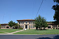
 Colony Park Pavilion |
|||

Wilburton is a city and county seat of Latimer County in the US state of Oklahoma with 2734 inhabitants (2014).
geography
The nearest major city of Fort Smith in the neighboring state of Arkansas is about 100 kilometers away in the northeast. McAlester is 40 kilometers to the west. The Oklahoma State Highway 2 and US Highway 270 intersect in Wilburton.
history
,_ca._1898_-_NARA_-_516380.jpg)
The region's native inhabitants were various Indian tribes , most of whom belonged to the Choctaw people . In 1890 the place was laid out as a stopover on the Butterfield Overland Mail - stagecoach route . The name Wilburton goes back with high probability to Will Burton, who was involved as an expert in the construction of a railway line for the Choctaw Coal and Railway Company . The main livelihood of the settlers was initially livestock farming. In the early 20th century , coal mining became the dominant industry. In the 1940s and 1950s, most of the coal was extracted from open-cast mining . Many of the miners needed came from Western Europe, most of them from Italy . The place has also been hit by some disasters. Several workers lost their lives in mine accidents and a sudden tornado in 1960 also claimed 13 lives .
Some historically valuable buildings and places from the early days of the place are listed on the National Register of Historic Places , including the Mitchell Hall (NR 80003270), the Rosenstein Building (NR 80003271) and the Sacred Heart Catholic Church and Rectory (NR 80003272).
Mitchell Hall
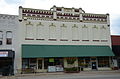
Rosenstein Building

Sacred Heart Catholic Church and Rectory


Demographic data
In 2014 a population of 2734 people was determined, which means a decrease of 8.0% compared to the year 2000. The average age of residents in 2014 was 30.8 years, below Oklahoma's average, which was 36.2 years. The share of the inhabitants that can be traced back to the indigenous people was 12.6% at that time.
Individual evidence
Web links
- LutieCoalMinersMuseum - Lutie Coal Miners Museum