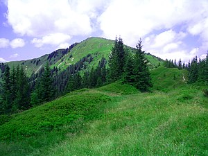
Wild field
| Wild field | ||
|---|---|---|
|
View of the wild field |
||
| height | 2043 m above sea level A. | |
| location | Styria , Austria | |
| Mountains | Eisenerzer Alps , Ennstal Alps | |
| Dominance | 1 km → Stadelstein | |
| Notch height | 63 m ↓ saddle to Speikkogel | |
| Coordinates | 47 ° 28 '57 " N , 14 ° 50' 52" E | |
|
|
||
| rock | Flaser and band lime | |
| Age of the rock | Lower Devon | |
The wild field is 2043 m above sea level. A. high summit of the Eisenerzer Alps in Styria .
The wild field is located in the main ridge of the mountain range, about 30 km long, roughly in the middle between Zeiritzkampel ( 2126 m ) and Eisenerzer Reichenstein ( 2165 m ). The name is derived from the wild richness of its botanical interest plateau, with their troughs and Karen a good Äsung offers for the Wild. Other peaks in the wild campaign are the Speikkogel ( 2040 m ) and the Stadelstein ( 2070 m ).
From the south to the east, the summit has steep, somewhat brittle rock walls , but is accessible by three good paths:
- The mountain rises 7 km southwest of the mining town of Eisenerz and can be climbed from there via the Ramsau valley
- from the south-east from Trofaiach following the 13 km long Trofaiacher Gößgraben (since there are too many ski tourers on some winter weekends, a strict park regulation had to be introduced for the Trofaiacher Gößgraben)
- from the south, from Kalwang through the Langteichengraben
The Eisenerzer-Alpen-Kammweg (No. 673) runs over the summit .
In winter the wild field is a popular destination for ski tours , which is why the locals sometimes call it the “Styrian Arlberg”.
Individual evidence
- ^ A b Hermann Scharfetter, Liselotte Buchenauer: Eisenerzer Alpen , 1978, Verlag Styria. ISBN 3-222-11096-4 , pp. OA
- ↑ The Eisenerzer-Alpen-Kammweg. bergwelten.com - Tour description with map.


