
Residential building group Blumenthalstrasse
.jpg)
The Blumenthalstrasse residential group in Bremen , Schwachhausen district, Barkhof district , Blumenthalstrasse 7–16, Parkstrasse 120, was built between 1904 and 1910 according to plans by Wilhelm Blanke . This group of buildings has been a listed building in Bremen since 1980 .
The short Blumenthalstrasse leads north-south from Parkstrasse via Hermann-Böse-Strasse to Hohenlohestrasse . It was named after the Prussian Field Marshal Leonhard von Blumenthal (1810–1900). The Hermann-Böse-Gymnasium from 1905 is also located on the street .
history
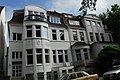
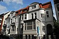
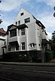
The plastered, two-storey houses with pitched and hipped roofs were built at the turn of the century in the neoclassical style for a middle-class upper class. The often chosen house type Bremer Haus was built in Bremen between the mid-19th century and the 1930s. The basement as a basement , the deep building shape and the side entrance are typical .
The State Office for the Preservation of Historic Monuments in Bremen found: "At that time it was ensured through urban planning decisions that only houses of the upper class with a very high architectural standard could be built here and that the site of the former Herdentorsfriedhof could not be built upon at first."
The ensemble includes the houses Koch (No. 7), Linck (No. 8), Lahusen (No. 10), Delius (No. 11), Marwede and Dubbers (No. 12A), Heye (No. 14), Biermann (No. 15), Lürman (No. 16).
- The Reich judge Diedrich Lahusen lived in No. 10 ;
- in No. 15 the merchant, art collector and patron Leopold Biermann , who expanded his house in 1907 with a winter garden based on plans by Carl Eeg and Eduard Runge; In 1909 Rudolf Alexander Schröder rebuilt the inside of the house; the house is also protected as an individual monument; the library is today (2017) in the New Town Hall , 2nd floor, east side, in the so-called Rudolf-Alexander-Schröder-Zimmer ;
- in No. 16 Senator Friedrich August Theodor Lürman ; the house is also protected as an individual monument.
Houses 9 and 12 are part of the ensemble and have no monument value of their own.
Currently (2017) the houses are used for apartments, as offices and as practices. Two four and five-story new residential buildings disturb the cohesion of the ensemble.
In No. 10 you will find the Association for Inner Mission in Bremen , a house of the Diakonie, various outpatient services, the office of the Bremer Ecumenical Dormitory and a pregnancy counseling and family help.

No. 7
No. 8
No. 10

No. 11

No. 12A
No. 14


See also
- Feldstrasse residential group
- Residential building group Goebenstrasse
- Residential building group Delbrückstrasse
- Residential house group Hermann-Allmers-Strasse
literature
- Detlev G. Gross and Peter Ulrich: Bremen houses tell history . Bremen 1998.
- Ralf Habben: One hundred years of the Parkviertel . Edition Temmen , Bremen 1999, ISBN 3861086263 .
Individual evidence
Coordinates: 53 ° 5 ′ 4.9 ″ N , 8 ° 49 ′ 7.9 ″ E