Wollbach (Kander)
|
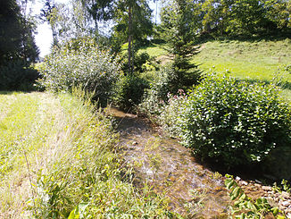
Wollbach right upper course: Rehgraben |
||
|
The Wollbach in the village of Wollbach |
||
| Data | ||
| Water code | DE : 23324 | |
| location |
Baden-Württemberg district of Loerrach |
|
| River system | Rhine | |
| Drain over | Kander → Rhine → North Sea | |
| source | at Sandelkopf 47 ° 42 '46 " N , 7 ° 42' 4" O |
|
| Source height | approx. 670 m above sea level NN Q. d. Deer ditch | |
| muzzle | near Kandern - Wollenbach from the left into the Kander coordinates: 47 ° 40 ′ 1 ″ N , 7 ° 38 ′ 37 ″ E 47 ° 40 ′ 1 ″ N , 7 ° 38 ′ 37 ″ E |
|
| Mouth height | approx. 292 m above sea level NN | |
| Height difference | approx. 378 m | |
| Bottom slope | approx. 45 ‰ | |
| length | 8.3 km with orienteering Rehgraben | |
| Catchment area | 13 km² | |
|
The Wollbach between the village of Wollbach and the suburb of Nebenau |
||
The Wollbach is an over 8 km long southern Black Forest stream in southwest Baden-Württemberg , which flows into the Kander from the left and east near Kandern - Wollbach in the district of Lörrach . Its official right upper course is called Rehgraben .
geography
course
The Wollbach rises as a Rehgraben on the Sandelkopf, about 3 km east of the center of the eponymous capital of the municipality of Kandern . He soon flows after the unification of its two headwaters Rehgraben (right) and Bear Pit (left) on the glass farm community over, much further down the valley then the locations Nebenau and Wollbach , where he quickly in succession valley road L 134 of Kander Valley and the local museum railway underpass . Still on the edge of the soft patch of this place of the same name, it flows into the Kander from the left and east after a run of 8.3 km from the Rehgraben spring .
Catchment area
The Wollbach runs with fluctuations to the southwest through the municipality of Kandern , it has a bottom gradient of about 45 ‰ and a catchment area of 13.0 km², the greater part of which is forested. In its west and north it is bordered by the Kander itself, here it is a direct competitor almost everywhere, only in the northwest on a small piece of the Kandern tributary, the Roter Graben, on the left . Beyond the eastern and south-eastern watershed, the meadow takes on its direct competitors, namely one after the other the Steinenbach , from which the Aubächle tributary competes, then the Heilisaubach , the Sormattbach and the Schwarzgraben .
Tributaries
- List of tributaries with designated names from the source to the mouth. Water lengths usually according to LUBW-FG10 (data record entries), height information according to the contour image on the geodata viewer. Other sources for the information are noted.
- Rehgraben , right upper course, 1.066 km.
- Bärengraben , left upper course, 1.004 km.
- Munzenbach , from the left, 1.414 km.
- Eulenlochbächle , from the left at the end of Nebenau , 2.418 km.
Individual evidence
- ↑ a b According to the contour line image on the geodata viewer.
- ↑ According to LUBW-FG10 (data record entry).
- ↑ According to LUBW-GEZG (data record entry).
- ↑ According to LUBW-FG10, which calculates this upper course to the Wollbach.
- ↑ On the geodata viewer or its LUBW-FG10 layer.
Web links
-
Geoportal Baden-Württemberg ( information ), especially with the partial maps / layers
- the State Institute for the Environment, Measurements and Nature Conservation Baden-Württemberg (LUBW)
- "LUBW-FG10": River 1: 10,000
- "LUBW-GEZG": water catchment areas
- the State Institute for the Environment, Measurements and Nature Conservation Baden-Württemberg (LUBW)

