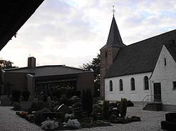
Wyler (Kranenburg)
|
Wyler
Community Kranenburg
Coordinates: 51 ° 48 ′ 29 " N , 5 ° 57 ′ 40" E
|
|
|---|---|
| Height : | 25 m |
| Residents : | 564 (Jan. 1, 2018) |
| Incorporation : | 1st July 1969 |
Wyler is a district of the municipality of Kranenburg in the Kleve district , North Rhine-Westphalia . With its residential development, it borders directly on the Netherlands and had 564 inhabitants in January 2018.
history
The place was first mentioned as Wilre in 1189. A chapel is mentioned in 1304, it was a branch of Zyfflich . But Wyler is much older. It was founded in Roman times. In the gravel pit on the Wylerberg, finds from early medieval graves dating from the 7th and early 8th centuries have been recovered several times. Mergelp Castle was located on the Wylerberg in the Middle Ages .
In the nearby Reichswald and in the vicinity of today's location, the so-called Battle of the Reichswald took place in the spring of 1945 . In this battle for the Lower Rhine the place was badly damaged. The old church tower, which was destroyed in the war, was a Romanesque tuff stone building. The church was rebuilt after the destruction. After Wyler had existed as a municipality in the district of Kranenburg since 1945 , it was incorporated into Kranenburg on July 1, 1969.
Change of the border with the Netherlands
After the Second World War , the Netherlands raised claims to German territory as compensation for war damage incurred (see: Dutch annexation plans after the Second World War ). Although these plans were largely rejected, with effect from April 23, 1949 , the British military government placed , among other things, parts of the municipality of Wyler with 170 inhabitants, in particular the Wylerberg , and uninhabited areas of the municipality of Zyfflich under contract administration from the Netherlands. A long-term dispute broke out over this, which was only settled in 1963 by a new border regulation treaty between Germany and the Netherlands. While most of the areas ceded in 1949 were returned to the Federal Republic, around four-fifths of the areas previously belonging to the municipalities of Wyler and Zyfflich remained permanently with the Netherlands.
economy
The federal road 9 runs alongside Wyler and merges into the Dutch N 325.
supporting documents
- ↑ Data and facts . In: kranenburg.de . Retrieved December 22, 2019
- ↑ Maurits Gysseling: Toponymisch Woordenboek van Belgie, Netherlands, Luxembourg, Noord-Frankrijk en West-Duitsland (voor 1226). without location 1960. - On the year 1223: Theodor Josef Lacomblet: Document book for the history of the Lower Rhine. Düsseldorf 1840-1858, Volume IV, p. 794, No. 650.
- ^ Friedrich Wilhelm Oediger: The churches of the archdeaconate Xanten. Bonn 1969, p. 324.
- ^ Frank Siegmund: Merovingian time on the Lower Rhine. Rhenish excavations 34. Rheinland-Verlag, Cologne 1998, p. 439f. with plate 219.
- ↑ Martin Bünermann: The communities of the first reorganization program in North Rhine-Westphalia . Deutscher Gemeindeverlag, Cologne 1970, p. 80 .
literature
- Association for homeland security (ed.), Kranenburg. A home book , Kranenburg 1984.
Web links
- Representation on the website of the municipality of Kranenburg

