Zbarbar
|
زبربر ⴰⵙⴻⵔⵔⵉⵡ Zbarbar |
||
|---|---|---|
|
|
||
| Coordinates | 36 ° 29 '5 " N , 3 ° 31' 33" E | |
| Basic data | ||
| Country | Algeria | |
| Bouira | ||
| ISO 3166-2 | DZ-10 | |
| height | 510 m | |
| surface | 58 km² | |
| Residents | 3768 (2008) | |
| density | 65 Ew. / km² | |
|
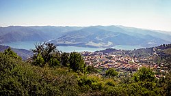
Zbarbar - location view
|
||
Zbarbar ( Arabic زبربر; Central Atlas Tamazight ⴰⵙⴻⵔⵔⵉⵡ Aserriw ) is a place with approx. 2,500 and a municipality (commune) with approx. 4,000 inhabitants in the province of Bouira in northern Algeria .
Location and climate
The place is located in Zbarbar Tellatlas -Gebirge on the north side of the 350 m high koudiat acerdoune dam of Oued Isser at an altitude of approximately 510 m . Zbarbar is approx. 100 km (driving distance) in a southeast direction from Algiers ; the provincial capital Bouira is another approx. 65 km southeast. The climate is mostly temperate to warm; Rain falls mainly in the winter months.
population
| year | 1977 | 1987 | 1998 | 2008 |
|---|---|---|---|---|
| Residents | k. A. | k. A. | 4,525 | 3,768 |
Since the 1960s, Zbardar has experienced a slight migration of formerly rural and self- sufficient Berber families to the cities of Algeria.
economy
Agriculture in the area is mainly characterized by grain and oil production; the livestock plays a certain role. Small traders, craftsmen and service providers of all kinds have settled in the village.
Attractions
Apart from its location, the place has no sights.

