
Zhuolan
|
Zhuolan 卓蘭 鎮 |
|||
.svg) Location of Zhuolan in Miaoli County |
|||
| State : |
|
||
| County : | Miaoli | ||
| Coordinates : | 24 ° 19 ′ N , 120 ° 52 ′ E | ||
| Area : | 76.3153 km² | ||
| Residents : | 16,338 (June 2020) | ||
| Population density : | 214 inhabitants per km² | ||
| Time zone : | UTC + 8 (Chungyuan time) | ||
| Telephone code : | (+886) (0) 37 | ||
| Postal code : | 369 | ||
| ISO 3166-2 : | TW-MIA | ||
| Community type : | City municipality ( 鎮 , Zhèn ) | ||
| Structure : | 11 districts ( 里 , Li ) | ||
| Website : | |||
|
|||

Zhuolan ( Chinese 卓蘭 鎮 , Pinyin Dàhú Xiāng ) is a township ( 鎮 , Zhèn ) in Miaoli County in the Republic of China (Taiwan) .
location
Zhuolan is located in a transition zone between the central mountains of Taiwan and the western plains. The southern boundary is formed by the course of the Da'anxi ( 大安溪 ), which flows in an east-west direction. In the northwest, the boundary is formed by the Liyutan reservoir . In terms of landscape geography , the municipality can be divided into two parts, the northern Zhuolan mountainous region ( 卓蘭 山地 ) and the southern Zhuolanpu region ( 卓蘭 埔 地 ). The approximate boundary is the small river or brook Laozhuang Xi ( 老庄 溪 ), a tributary of the Da'anxi. The former includes a mountainous area between 300 and 700 meters high and the latter the area of the Da'anxi River Plain and several low terraces of different sizes. The annual mean temperature is 24 ° C and the annual precipitation is around 2100 mm and is mainly concentrated in the months May to June and August to October. The neighboring communities in Miaoli County are Sanyi in the west, Dahu in the north, and Tai'an in the east. In the south Zhuolan borders the district Dongshi of Taichung .
history
The original inhabitants of the area were members of the indigenous Taiwanese ethnic group, the Atayal . The first Han Chinese settlers arrived in Zhuolan in 1723 at the beginning of Yongzheng's reign . Most of them came from the southern Chinese provinces of Guangdong and Fujian ( Zhangzhou ). The place name used by the immigrants was originally Dǎlán or Dálián . This became in Minnan Talan ( 罩 蘭 , Pe̍h-ōe-jī Tàlân ). At the time of the Japanese rule over Taiwan (1895-1945), the village Zhuolan ( 卓蘭 庄 , Zhuōlán zhuāng ) was formed in 1920 by a slight change in the first character . After Taiwan was taken over by the Republic of China in 1945, the rural community of Zhuolan ( 卓蘭 鄉 , Zhuōlán xiāng ) emerged. From October 11, 1946, Zhuolan was part of Hsinchu County and from October 25, 1950 part of the newly established Miaoli County. On January 16, 1956, Zhuolan received the status of a township ( 鎮 , Zhèn ).
population
The majority of the population speaks Hakka as their mother tongue. The proportion of Hakka speakers is estimated in various surveys at 76 to 84 percent. Most of the rest are Minnan speakers. At the end of 2019, 158 members of indigenous peoples lived in Zhuolan, corresponding to a population share of 1.0%.
| Outline of Zhuolan |
|
|
_villages.svg)
Administrative division
Zhuolan is divided into 11 districts ( 里 , Li ):
1 Zhongjie ( 中 街 里 )
2 Xinrong ( 新 榮 里 )
3 Xincuo ( 新厝 里 )
4 Miaofeng ( 苗 豐 里 )
5 Fengtian ( 豐田 里 )
6 Laozhuang ( 老庄 里 )
7 Xiping ( 西坪 里 )
8 Shangxin ( 上 新 里 )
9 Neiwan ( 內 灣里 )
10 Pinglin ( 坪林 里 )
11 Jingshan ( 景山 里 )
economy
Regardless of its status as a "township", Zhuolan is strongly characterized by agriculture. The focus is on fruit growing with the main products Nashi pears (approx. 1,200 hectares, May to July, September / October), grapes (July to September, December to February), star fruits (early September to early April) and citrus fruits (November till May).
traffic
Due to the relatively mountainous topography, there are only a few major roads. County road 140 runs directly along the north bank of Dajiaxi. In the western section, the Provincial Road 3 crosses the municipality in an arched course.
particularities
The Liyutan Reservoir ( 鯉魚 潭 水庫 ) is a reservoir with an effective storage capacity of 116 million m³. The reservoir and dam are used for public water supply, irrigation for agriculture and tourist purposes. Zhuolan offers various opportunities for nature tourism. On the southern border with Taichung, the Da'anxi flows in sections through a narrow canyon about 300 m long and more than 10 m deep, known as the Da'anxi Canyon ( 大安溪 峽谷 ), Da'anxi Grand Canyon ( 大安溪 大 峽谷 ) or Zhuolan Grand Canyon ( 卓蘭 大 峽谷 ) is known ( ). The shape of the canyon was shaped significantly by the 921 earthquake in 1999. In the district of Xincun is the Elun Temple ( 峨 崙 廟 , Élún miào ), a Daoist temple in which the "King of the Three Mountains" Sanshan ( 三 山 國王 ) is venerated. A first temple was built in 1823. Multiple conversions and new buildings took place later. Other temples are the Daoist Zhaozong Temple ( 昭 忠 廟 , Zhāozhōng miào ) in the Laozhuang district, the Daoist Shuangfeng Temple ( 雙鳳 宮 , Shuāngfèng gōng ) in the Pinglin district, the Buddhist Miaoyun-Jingshe in the Xiping district ( 妙雲 精舍 , Miàoyún jīngshě ), the Beitian Sanxuan Temple ( 北 天 三玄 宮 , Běitiān sānxuán gōng ) in the district of Xiping, a temple of Xiwangmu , and the Chaonan temple ( 朝 南宮 , Cháonán gōng ) in the district of Jingshan.
![]()
![]()
![]()
![]()
![]()
![]()
 Liyutan reservoir
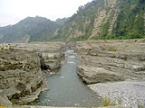 Da'anxi "Grand Canyon"
 Zhaozhong Temple


Web links
Individual evidence
- ↑ 地理 環境 (Geographic Area). Zhuolan's website, accessed August 8, 2020 (Chinese (traditional)).
- ↑ 罩 蘭. Retrieved August 8, 2020 (Chinese (traditional), entry "罩 蘭" in the Minnan dictionary 臺灣 閩南 語 常用 詞 辭典 ).
- ↑ 歷史 沿革 (history). Zhuolan's website, accessed August 4, 2020 (Chinese (traditional)).
- ↑ 楊文 山 (Yang Wenshan): 全國 客家 人口 基礎 資料 調查 研究 ("Basic data survey on the national Hakka population") . 2004, ISBN 957-01-9320-4 , appendix: 鄉鎮 市區 臺灣 客家 人口 數 及 比例 (“Number and proportion of the Taiwanese Hakka population in municipalities and cities”) - (Chinese (traditional), pdf ).
- ↑ 原住民 戶數 及 人數 Households and Persons of Indigenous People. (xls) Taiwan Ministry of the Interior, accessed May 14, 2020 (Chinese, English).
- ↑ 農 特 產品 (“Special agricultural products”). Zhuolan's website, accessed August 8, 2020 (Chinese (traditional)).
- ↑ 道路 交通 (traffic routes). Zhuolan's website, accessed August 8, 2020 (Chinese (traditional)).
- ↑ reservoirs, dams and weirs of Taiwan. Water Resources Office of the Taiwanese Ministry of Economic Affairs, accessed August 11, 2020 .
- ↑ 中 臺灣 河川 新 地貌 (一) 大安溪 峽谷 (New landforms of rivers in central Taiwan (1) Daanxi Canyon). Taichung National Natural History Museum website, accessed August 13, 2020 (Chinese (traditional)).
- ↑ 卓蘭 峨 崙 廟. (Academia Sinica Geographic Information System for Cultural Resources). 文化 資源 地理 資訊 系統, Retrieved August 13, 2020 (Chinese (traditional)).
- ↑ 卓蘭 鎮 (Zhuolan Township). (Academia Sinica Geographic Information System for Cultural Resources). 文化 資源 地理 資訊 系統, Retrieved August 13, 2020 (Chinese (traditional)).