
Tai'an (Miaoli)
|
Tai'an 泰安 鄉 |
|||
.svg) Location of Tai'an in Miaoli County |
|||
| State : |
|
||
| County : | Miaoli | ||
| Coordinates : | 24 ° 25 ' N , 121 ° 3' E | ||
| Height : | 4 - 3886 m | ||
| Area : | 614.5127 km² | ||
| Residents : | 5,888 (Dec 2019) | ||
| Population density : | 10 inhabitants per km² | ||
| Time zone : | UTC + 8 (Chungyuan time) | ||
| Telephone code : | (+886) (0) 37 | ||
| Postal code : | 365 | ||
| ISO 3166-2 : | TW-MIA | ||
| Community type : | Rural community ( 鄉 , Xiāng ) | ||
| Structure : | 8 villages ( 村 , Cūn ) | ||
| Website : | |||
|
|||

Tai'an ( Chinese 泰安 鄉 , Pinyin Tài'ān Xiāng ) is a rural community ( 鄉 , Xiāng ) in Miaoli County in the Republic of China (Taiwan) .
description
Tai'an is located inland in the east of the district of Miaoli and is the largest district municipality in terms of area with around a third of the total district area. With less than 6,000 inhabitants, Tai'an is very sparsely populated and ranks last among the county councils in terms of population. The municipality is predominantly located in the western foothills of the Xueshan Mountains . The height above sea level varies between 4 meters in the valleys and over 3800 meters in the high mountains and increases from west to east. The highest mountain peaks are located on the municipal boundaries: the Xueshan ( 雪山 - "Snow Mountain", 3886 m), Daxueshan ( 大雪山 , Dà xuěshān , 3530 m) and Dabajianshan ( 大霸尖山 , Dàbà jiānshān , 3492 m). The dominant flowing water is the Da'anxi ( 大安溪 ) whose catchment area makes up about three quarters of the area of Tai'an and in whose river valley the majority of the population lives. The neighboring communities are in the northern district of Hsinchu Wufeng in the north and Jianshi in the east, in the city of Taichung in the south the district of Heping , and in the district of Miaoli Nanzhuang in the north, and (from north to south) Shitan , Dahu and Zhuolan in the west.
history
The original inhabitants of the area were Austronesian ethnic groups, the ancestors of today's indigenous peoples of Taiwan . Due to its accessibility, the region was never really under the control of Chinese authorities when Taiwan belonged to the Chinese Empire of the Qing Dynasty and was only subjected to and administratively recorded during the time of Japanese colonial rule (1895-1945). From 1920 the area of Tai'an belonged to Dahu County ( 大湖 郡 ) within Shinshiku Prefecture ( 新竹 州 ). After Taiwan was taken over by the Republic of China in 1945, Tai'an first came to Hsinchu County, and on October 25, 1950, it became part of the newly established Miaoli County as the rural community Da'an ( 大安 鄉 , Dà'ān xiāng ). Since there was also a community of the same name in the neighboring district of Taichung , the name was changed in 1954 to the similarly sounding Tai'an .
population
At the end of 2018, 4348 members of indigenous peoples were counted, which corresponded to a share of the population of around 74%. Most of them were Atayal . The rest of the population is mostly made up of Hakka , the majority of whom live in Qing'an village.
| Structure of Tai'an |

|
Administrative division
Tai'an is divided into 8 villages ( 村 , Cūn ):
1 Bagua ( 八卦 村 )
2 Jinshui ( 錦 水 村 )
3 Qing'an ( 清 安 村 )
4 Daxing ( 大興 村 )
5 Zhongxing ( 中興 村 )
6 Shilin ( 士林 村 )
7 Xiangbi ( 象鼻 村 )
8 Meiyuan ( 梅園 村 )
Transport links
Due to the mountainous topography, there are no major road connections. Only in the west of the municipality there are two larger municipal roads that serve as feeder roads to Provincial Road 3, which runs past Tai'an a few kilometers away in a north-south direction to the west.
economy
Main branches of business are agriculture and tourism. Bamboo ( Phyllostachys reticulata ), plums, ginger , Japanese apricots , dragon fruits , wet rice , pineapples , citrus fruits , peaches , strawberries and various vegetables are grown .
particularities
The main attractions are nature, which is particularly popular for hiking and mountaineering, and the culture of the local Atayal. Of all municipalities, Tai'an has the largest share of the Shei-Pa National Park with 39,536 hectares , which takes up the entire eastern part of the municipality. There are traces of geothermal activity in various places. In the village of Zhongxing, natural gas leaks from the ground at various points and burns down with a small flame. Hot springs can be found in Jinshui Village.

Mount Dabajianshan
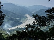
Da'anxi River Valley

Shilin weir or reservoir


Web links
Individual evidence
- ↑ 地理 環境 ("Geographical Environment"). Tai'an website, accessed February 18, 2020 (Traditional Chinese).
- ↑ 歷史 沿革 ("Temporal History"). Tai'an website, accessed February 18, 2020 (Traditional Chinese).
- ↑ 原住民 戶數 及 人數 Households and Persons of Indigenous People. (xls) Ministry of Interior of Taiwan, accessed November 30, 2019 (Chinese, English).
- ↑ a b 行政 區域. Tai'an website, accessed February 18, 2020 (Traditional Chinese).
- ↑ 交通 網路 ("Transport Network"). Tai'an website, accessed February 18, 2020 (Traditional Chinese).
- ↑ a b 各村 簡介 ("Introduction to the Villages"). Tai'an website, accessed February 18, 2020 (Traditional Chinese).
- ↑ 各 國家 公園 基本 資料 表 (“Basic information table about the national parks”). October 5, 2009, Retrieved July 6, 2019 (Chinese (traditional), English).