
Jianshi (Hsinchu)
|
Jianshi 尖石 鄉 |
|||
.svg) Location of Jianshi in Hsinchu County |
|||
| State : |
|
||
| County : | Hsinchu | ||
| Coordinates : | 24 ° 35 ' N , 121 ° 18' E | ||
| Area : | 527.5795 km² | ||
| Residents : | 9,638 (Dec 2019) | ||
| Population density : | 18 inhabitants per km² | ||
| Time zone : | UTC + 8 (Chungyuan time) | ||
| Telephone code : | (+886) (0) 3 | ||
| Postal code : | 313 | ||
| ISO 3166-2 : | TW-HSQ | ||
| Community type : | Rural community ( 鄉 , Xiāng ) | ||
| Structure : | 7 villages ( 村 , Cūn ) | ||
| Website : | |||
|
|||

Jianshi ( Chinese 尖石 鄉 , Pinyin Jiānshí Xiāng ) is a rural community ( 鄉 , Xiāng ) in Hsinchu County in the Republic of China (Taiwan) .
description
Jianshi is located in the inland in the southeast of Hsinchu County. With 528 km² it is the largest municipality in terms of area and takes up more than a third of the area of the district, but with fewer than 10,000 inhabitants it only houses just under 2 percent of its population.
The neighboring communities are Hsinchu Hengshan and Wufeng counties in the west, Guanxi in the north, Fuxing counties in Taoyuan town in the north-east, Yilan Datong counties in the south-east, Taichung town heping townships in the south and Miaoli Tai ' counties on in the southwest. Jianshi lies in the area of the southwestern foothills of the Xueshan Mountains . Jianshi is separated from southern Heping by a chain of several high mountain peaks. The highest is the Pintianshan ( 品 田 山 ) with 3524 m .
In terms of natural geography, Jianshi can be divided into two parts (see below): Qianshan ( 前 山 - "front mountain (s)") and Houshan ( 後 山 - "rear mountain (s)").
In the southeastern section, Jianshi has a small portion of the Shei-Pa National Park (a total of 5416 ha).
history
The community name Jianshi (lit. "pointed stone") is derived from an approximately 35 m high and 20 m wide boulder that stands at the confluence of the small rivers Naluo ( 那 羅溪 , Nàluó xī ) and Jiale ( 嘉樂 溪 , Jiālè xī ) is located. The original inhabitants of the area were members of indigenous Austronesian peoples who were only subjected to stubborn resistance at the time of Japanese colonial rule (1895-1945). During the Japanese period, an administrative reform took place on October 1, 1920, which made Jianshi administratively part of Zhudong County ( 竹 東郡 ) in Shinchiku Prefecture . After the Republic of China took over the island of Taiwan in 1945, Jianshi was organized on March 1, 1946 as a 'rural community' ( 鄉 , Xiāng ) in the newly formed Hsinchu County.
| Outline of Jianshi |

|
Administrative division

Jianshi is divided into seven villages:
1 Yixing ( 義興 村 )
2 Jiale ( 嘉樂 村 )
3 Xinle ( 新 樂 村 )
4 Jinping ( 錦屏 村 )
5 Meihua ( 梅花村 )
6 Xiuluan ( 秀 巒 村 )
7 Yufeng ( 玉峰 村 )
The administrative headquarters are in Jiale. The five villages of Xinle, Jiale, Jinping, Yixing and Meihua make up the Qianshan region, and the two villages of Yufeng and Xiulan make up the Houshan region .
population
The majority of the population consists of members of indigenous peoples, especially Atayal . At the end of 2018 this was 8,490 people (85–90%). The rest of the population consists mostly of Hakka .
traffic
The only supraregional road is the county road 120, which leads from the west of Hengshan to Jiasnhi and there runs through the villages Jiale and Xinle, where it ends.
particularities
The eponymous "pointed stone" ( ) in the village of Jiale is a tourist destination. Another prominent rock is the Junjian rock ( 軍艦 岩 , Jūnjiàn yán - "warship rock" ) in the village of Xiuluan. There are several hot springs not far from here. There are other hot springs in Jinping Village ( ). In places there are very old forests, including more than 2000 year old red Formosa cypress trees, which are among the oldest trees in Taiwan.
![]()
![]()
![]()
A historical attraction are the remains of the old Tapung Fort in the village of Yufeng on the border with the urban area of Taoyuan (formerly Japanese Lidonsan , Chinese 李 崠 古堡 , Lǐdōng gǔ bǎo , ), a former Japanese fortified police station in the remote mountainous region of Jianshi, which was the site of fighting between the Japanese and the indigenous Atayal in the early 20th century.
![]()
The Atayal settlement Smangus (Chin. 司 馬庫斯 , Sīmǎkùsī , ) in Xiuluan is a kibbutz- like village community, located on a remote plateau approx. 1500 m above sea level , which is dedicated to ecological and nature tourism.
![]()

Bamboo forest in Yufeng Village
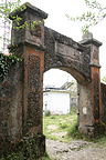
Entrance gate to Fort Tapung

Junjian rocks
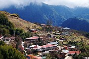
Smangus
.jpg)
_-_%E9%96%80%E5%8F%A3%E6%AD%A3%E9%9D%A2.JPG)


Web links
Individual evidence
- ↑ a b 尖石 介紹 ("Introduction to Jianshi"). Jianshi website, accessed February 15, 2020 (Traditional Chinese).
- ↑ a b Tourist sites in Jianshi. Jianshi website, accessed February 16, 2020 .
- ^ Culture. Jianshi website, accessed February 16, 2020 .
- ↑ Jinping Hot Spring. taiwan.net.tw, accessed February 16, 2020 .
- ↑ Jianshi Giant Trees. taiwan.net.tw, accessed February 16, 2020 .
- ↑ Tapung (Lidonsan) Castle. Jianshi website, accessed February 16, 2020 .
- ↑ stu: Tapung Fort, Hsinchu County - 李棟 山 古堡. hikingtaiwan.wordpress.com, November 18, 2009, accessed February 16, 2020 .
- ^ Cultural Heritage. Hsinchu County Cultural Office, accessed February 16, 2020 .
- ↑ 'Smangus is God's tribe'. Taipei Times, November 8, 2004, accessed February 16, 2020 .
- ^ George Liao: My trip to most remote community in northern Taiwan — Smangus, the 'Tribe of God'. Taiwan News, August 8, 2018, accessed February 16, 2020 .
- ↑ Oscar Chung: Communal Harmony. May 1, 2018, accessed February 16, 2020 .