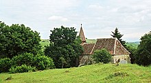
Zlagna
|
Zlagna Schlatt Szászzalatna |
||||
|
||||
| Basic data | ||||
|---|---|---|---|---|
| State : |
|
|||
| Historical region : | Transylvania | |||
| Circle : | Sibiu | |||
| Municipality : | Bârghiș | |||
| Coordinates : | 45 ° 57 ' N , 24 ° 3' E | |||
| Time zone : | EET ( UTC +2) | |||
| Height : | 486 m | |||
| Residents : | 183 (2002) | |||
| Postal code : | 557040 | |||
| Telephone code : | (+40) 02 69 | |||
| License plate : | SB | |||
| Structure and administration | ||||
| Community type : | Village | |||
Zlagna ( German Schlatt , såksesch Schlått , Hungarian Szászzalatna ) is a village in Transylvania , Romania . It belongs to the municipality of Bârghiş ( Bürgerisch ) and is located near Agnita ( Agnetheln ) in the northern part of the Sibiu ( Hermannstadt ) district.
history

Schlatt was founded around 1300 by German settlers ( Transylvanian Saxons ) as a subordinate village on the aristocratic soil . It is assumed that it was founded by Saxon counts from Alzen and Talmesch ; However, it came into the possession of the diocese of Weißenburg . The first documentary mention is from 1318. In another document from 1336 it is recorded that Schlatt (as Hörigendorf) lies in the middle of the Saxon area of the Sibiu Province of the Seven Chairs . After hundreds of years of compulsory labor, the residents, who were called "servants of several masters", broke away from the Weissenburg Cathedral Chapter in 1560, but remained subjects of Hungarian nobles, who they had to do three days a week of labor. The serfdom was abolished completely for the inhabitants of Schlatt only. 1856
population
For centuries the place was mostly inhabited by Transylvanian Saxons. From the middle of the 19th century, the Romanian inhabitants gained the majority. Up until the revolution of 1989 , a significant proportion of Saxon residents lived in Schlatt; after that most of them emigrated. The population, which has steadily declined since 1930, was 183 in 2002, less than a quarter of the 1930 population - 789 at the time, 491 of whom were Romanians and 298 Germans.
Today, Zlagna ( Schlatt ), together with the neighboring villages of Apoș ( Abtsdorf ), Ighișu Vechi ( Wallachian-Eibesdorf ), Pelișor ( Magarei ) and Vecerd ( Bußthard ), is administratively part of the large municipality of Bârghiș ( Burgisch ).
literature
- Walter Myß (Ed.): The Transylvanian Saxons. Dictionary. History, culture, civilization, science, economy, living space Transylvania (Transylvania). License issue. Kraft, Würzburg 1993, ISBN 3-8083-2018-4 .
- Heinz Heltmann, Gustav Servatius (Hrsg.): Travel guide to Transylvania. Wort und Welt Verlag, Thaur near Innsbruck 1993, ISBN 3-85373-133-3 .
- Árpád E. Varga: Szeben megye településeinek etnikai (anyanyelvi / nemzetiségi) adatai 1850–2002. (Online document) (PDF file; 582 kB).
Footnotes
- ↑ On the map 206 of the Josefinische Landesaufnahme von Siebenbürgen from 1769-1773 between Almen (Szász Almád) and Schatt (Zalatna) the borderline between Königsboden and Komitatsboden is drawn. In the area there were several county floor enclaves in the middle of the king floor.


