
Zwölferkogel (Stubai Alps)
| Zwölferkogel | ||
|---|---|---|
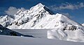
.jpg) The Zwölferkogel from the northeast |
||
| height | 2988 m above sea level A. | |
| location | south of Kühtai / Tyrol | |
| Mountains | Stubai Alps | |
| Dominance | 0.8 km → Sulzkogel | |
| Notch height | 125 m ↓ Zwölferkarscharte | |
| Coordinates | 47 ° 11 '24 " N , 11 ° 0' 37" E | |
|
||
| Type | Rock peaks | |
| rock | Gneiss | |
| Normal way | from Kühtai through the Finstertal over the southeast flank or through the Langental and Zwölferkar | |

The Zwölferkogel is 2988 m above sea level. A. high mountain in the Stubai Alps in the Austrian state of Tyrol .
topography
The Zwölferkogel is about 2.7 kilometers south of the Kühtai winter sports resort . The northwest face of the Zwölferkogel slopes down around 500 meters towards the Längental . In the east below lies the Finstertal with the Finstertal reservoir , a storage lake belonging to the Sellrain-Silz power plant group . To the south close over a sharp ridge the 2934 m above sea level. A. high midday heads , the 2929 m above sea level. A. high noon storm and the 3016 m above sea level. A. high Sulzkogel .
gallery
Zwölferkogel behind the Finstertal reservoir dam

Zwölferkogel


Web links
Commons : Zwölferkogel - Collection of images, videos and audio files
Individual evidence
- ↑ bergstieg.com: Zwölferkogel through the Zwölferkar