
Kravaře: Difference between revisions
population, history, geography, sights |
population |
||
| (8 intermediate revisions by 3 users not shown) | |||
| Line 2: | Line 2: | ||
{{Infobox settlement |
{{Infobox settlement |
||
| name = Kravaře |
| name = Kravaře |
||
| native_name = |
|||
| other_name = |
| other_name = |
||
| settlement_type = [[Obec|Town]] |
| settlement_type = [[Obec|Town]] |
||
<!-- images |
<!-- images --> |
||
| image_skyline = |
| image_skyline = Schloss Deutsch Krawarn.jpg |
||
| image_caption = Kravaře Castle |
| image_caption = Kravaře Castle |
||
| image_flag = Vlajka města Kravaře.svg |
| image_flag = Vlajka města Kravaře.svg |
||
| image_shield = Coat of arms of Kravaře (Opava District).svg |
| image_shield = Coat of arms of Kravaře (Opava District).svg |
||
| etymology = |
|||
<!-- location --> |
<!-- location --> |
||
| subdivision_type = Country |
| subdivision_type = Country |
||
| Line 29: | Line 27: | ||
| leader_title = Mayor |
| leader_title = Mayor |
||
| leader_name = Monika Brzesková |
| leader_name = Monika Brzesková |
||
| leader_party = {{polparty|Czech Republic|KDU-CSL}} |
|||
<!-- established --> |
<!-- established --> |
||
| established_title = First mentioned |
| established_title = First mentioned |
||
| Line 39: | Line 38: | ||
| elevation_m = 233 |
| elevation_m = 233 |
||
<!-- population --> |
<!-- population --> |
||
| population_as_of = |
| population_as_of = 2023-01-01 |
||
| population_footnotes = <ref>{{cite web |title=Population of Municipalities – 1 January |
| population_footnotes = <ref>{{cite web |title=Population of Municipalities – 1 January 2023|url=https://www.czso.cz/csu/czso/population-of-municipalities-1-january-2023|publisher=[[Czech Statistical Office]]|date=2023-05-23}}</ref> |
||
| population_total = |
| population_total = 6624 |
||
| population_density_km2 = auto |
| population_density_km2 = auto |
||
<!-- time zone(s) --> |
<!-- time zone(s) --> |
||
| Line 57: | Line 56: | ||
| footnotes = |
| footnotes = |
||
}} |
}} |
||
'''Kravaře''' ({{IPA-cs|ˈkravar̝ɛ}}; {{lang-de|Deutsch |
'''Kravaře''' ({{IPA-cs|ˈkravar̝ɛ}}; {{lang-de|Deutsch Krawarn}}) is a town in [[Opava District]] the [[Moravian-Silesian Region]] of the [[Czech Republic]]. It has about 6,600 inhabitants. It is part of the historic [[Hlučín Region]]. |
||
==Administrative parts== |
==Administrative parts== |
||
| Line 64: | Line 63: | ||
==Geography== |
==Geography== |
||
Kravaře is located about {{convert|6|km|0}} east of [[Opava]] and {{convert|20|km}} northwest of [[Ostrava]]. It lies in the [[Głubczyce Plateau|Opava Hilly Land]] |
Kravaře is located about {{convert|6|km|0}} east of [[Opava]] and {{convert|20|km|abbr=on}} northwest of [[Ostrava]]. It lies in the [[Głubczyce Plateau|Opava Hilly Land]]. The town is situated on the left bank of the [[Opava (river)|Opava]] River. |
||
==History== |
==History== |
||
| Line 71: | Line 70: | ||
The next important owner of Kravaře was [[Michael Sendivogius]], who received the estate during the [[Thirty Years' War]]. After his death in 1636, his daughter married the free lord of Eichendorff. In 1721–1728, Jan Rudolf Eichendorff had rebuilt the fortress into a late Baroque castle. The Eichendorffs had to sell the estate in 1782 due to debts. After that, Kravaře were held by less important owners.<ref name=history/><ref name=castle>{{cite web |title=Historie|url=https://www.zamekkravare.cz/o-zamku/historie/|publisher=Kravaře Castle|language=cs|access-date=2022-03-21}}</ref> |
The next important owner of Kravaře was [[Michael Sendivogius]], who received the estate during the [[Thirty Years' War]]. After his death in 1636, his daughter married the free lord of Eichendorff. In 1721–1728, Jan Rudolf Eichendorff had rebuilt the fortress into a late Baroque castle. The Eichendorffs had to sell the estate in 1782 due to debts. After that, Kravaře were held by less important owners.<ref name=history/><ref name=castle>{{cite web |title=Historie|url=https://www.zamekkravare.cz/o-zamku/historie/|publisher=Kravaře Castle|language=cs|access-date=2022-03-21}}</ref> |
||
Since 1742 Kravaře and Kouty belonged to [[Kingdom of Prussia|Prussia]] after [[Maria Theresa]] had been defeated. Dvořisko, located behind the Opava River, remained in [[Austrian Empire]]. In 1920, the area of Hlučín Region was returned to [[Czechoslovakia]]. During |
Since 1742 Kravaře and Kouty belonged to [[Kingdom of Prussia|Prussia]] after [[Maria Theresa]] had been defeated. Dvořisko, located behind the Opava River, remained in [[Austrian Empire]]. In 1920, the area of Hlučín Region was returned to [[Czechoslovakia]]. During [[World War II]], it was annexed by [[Nazi Germany]] and administered as part of [[Reichsgau Sudetenland]].<ref name=history/> |
||
For centuries Kravaře was only a village. In 1960, Kouty and Dvořisko were annexed to Kravaře and the new municipality gained the |
For centuries, Kravaře was only a village. In 1960, Kouty and Dvořisko were annexed to Kravaře and the new municipality gained the status of a town.<ref name=history/> |
||
== |
==Demographics== |
||
{{historical populations |
{{historical populations |
||
|align=none|cols=3 |
|align=none|cols=3 |
||
| Line 92: | Line 91: | ||
|2001|6693 |
|2001|6693 |
||
|2011|6570 |
|2011|6570 |
||
|2021| |
|2021|6537 |
||
|source= |
|source=Censuses<ref>{{cite web |title=Historický lexikon obcí České republiky 1869–2011 – Okres Opava|url=https://www.czso.cz/documents/10180/20537734/130084150805.pdf/74ea6676-9dd7-4c85-a985-ffbb4f9eb0f1?version=1.2|publisher=Czech Statistical Office|pages=5–6|language=cs|date=2015-12-21}}</ref><ref>{{cite web |title=Population Census 2021: Population by sex|url=https://vdb.czso.cz/vdbvo2/faces/en/index.jsf?page=vystup-objekt-parametry&z=T&f=TABULKA&sp=A&skupId=4429&katalog=33515&pvo=SLD21001-OB-OK|work=Public Database|publisher=[[Czech Statistical Office]]|date=2021-03-27}}</ref>}} |
||
==Sport== |
==Sport== |
||
| Line 105: | Line 104: | ||
==Sights== |
==Sights== |
||
[[File:Kravaře u Opavy (5).jpg|thumb|Church of Saint Bartholomew]] |
[[File:Kravaře u Opavy (5).jpg|thumb|Church of Saint Bartholomew]] |
||
One of the two main landmarks of the towns is Kravaře Castle. In 1990, the Baroque castle was acquired by the town. Today it serves as a cultural and social centre and houses a museum with permanent baroque and ethnographic exhibitions.<ref name=castle/> The castle includes a {{convert|21|ha}} large castle park with several ponds and with several rare tree species.<ref name=park/> |
One of the two main landmarks of the towns is Kravaře Castle. In 1990, the Baroque castle was acquired by the town. Today it serves as a cultural and social centre and houses a museum with permanent baroque and ethnographic exhibitions.<ref name=castle/> The castle includes a {{convert|21|ha|abbr=on}} large castle park with several ponds and with several rare tree species.<ref name=park/> |
||
The second landmark is the Church of Saint Bartholomew. The oldest part of the church is the white Renaissance tower from the early 16th century. The neo-Gothic church complex which includes the nave, the rectory and the former convent of the Sisters of the Heart of God (today the town hall), was built at the turn of the 19th and 20th centuries. The church was consecrated in 1896. Near the church there is a baroque sandstone statue of St. John of Nepomuk from 1730.<ref>{{cite web |title=Kostel sv. Bartoloměje|url=https://www.kravare.cz/pro-turisty/pamatky-a-zajimava-mista/kostel-sv-bartolomeje-0_248.html|publisher=Město Kravaře|language=cs|access-date=2022-03-21}}</ref> |
The second landmark is the Church of Saint Bartholomew. The oldest part of the church is the white Renaissance tower from the early 16th century. The neo-Gothic church complex which includes the nave, the rectory and the former convent of the Sisters of the Heart of God (today the town hall), was built at the turn of the 19th and 20th centuries. The church was consecrated in 1896. Near the church there is a baroque sandstone statue of St. John of Nepomuk from 1730.<ref>{{cite web |title=Kostel sv. Bartoloměje|url=https://www.kravare.cz/pro-turisty/pamatky-a-zajimava-mista/kostel-sv-bartolomeje-0_248.html|publisher=Město Kravaře|language=cs|access-date=2022-03-21}}</ref> |
||
| Line 112: | Line 111: | ||
*[[Pavel Kravař]] (1391–1433), [[Hussite]] physician burned at the stake for heresy |
*[[Pavel Kravař]] (1391–1433), [[Hussite]] physician burned at the stake for heresy |
||
*[[Michael Sendivogius]] (1566–1636), Polish alchemist, philosopher and physician; lived and died here |
*[[Michael Sendivogius]] (1566–1636), Polish alchemist, philosopher and physician; lived and died here |
||
*[[Karl Albert Scherner]] (1825–1889), German philosopher and psychologist |
|||
*[[Ivo Žídek]] (1926–2003), opera singer |
*[[Ivo Žídek]] (1926–2003), opera singer |
||
*[[Josef Jařab]] (1937–2023), academic and politician |
|||
*[[Evžen Hadamczik]] (1939–1984), football player and manager |
*[[Evžen Hadamczik]] (1939–1984), football player and manager |
||
*[[Alois Hadamczik]] (born 1952), ice hockey coach |
*[[Alois Hadamczik]] (born 1952), ice hockey coach |
||
Latest revision as of 09:15, 25 May 2023
Kravaře | |
|---|---|
 Kravaře Castle | |
 Flag .svg) Coat of arms | |
 Kravaře Location in the Czech Republic | |
| Coordinates: 49°56′10″N 18°0′37″E / 49.93611°N 18.01028°E | |
| Country | |
| Region | Moravian-Silesian |
| District | Opava |
| First mentioned | 1224 |
| Government | |
| • Mayor | Monika Brzesková (KDU-ČSL) |
| Area | |
| • Total | 19.37 km2 (7.48 sq mi) |
| Elevation | 233 m (764 ft) |
| Population (2023-01-01)[1] | |
| • Total | 6,624 |
| • Density | 340/km2 (890/sq mi) |
| Time zone | UTC+1 (CET) |
| • Summer (DST) | UTC+2 (CEST) |
| Postal code | 747 21 |
| Website | www |
Kravaře (Czech pronunciation: [ˈkravar̝ɛ]; German: Deutsch Krawarn) is a town in Opava District the Moravian-Silesian Region of the Czech Republic. It has about 6,600 inhabitants. It is part of the historic Hlučín Region.
Administrative parts[edit]
.jpg)
Town parts of Dvořisko and Kouty are administrative parts of Kravaře.
Geography[edit]
Kravaře is located about 6 kilometres (4 mi) east of Opava and 20 km (12 mi) northwest of Ostrava. It lies in the Opava Hilly Land. The town is situated on the left bank of the Opava River.
History[edit]
The first written mention of Kravaře is from 1224. Kouty was first mentioned in 1238 and Dvořisko in the second half of the 18th century. Between 1224 and 1263, the Kravaře estate was acquired by the lords from Benešov, who were further known as lords of Kravaře. From 13th to 15th century, it was one of the richest families in Moravia. In the second half of the 13th century, they had built a fortress in Kravaře. The last owner of Kravaře from this family was Petr Strážnický, who was forced to sell Kravaře in 1420.[2]
The next important owner of Kravaře was Michael Sendivogius, who received the estate during the Thirty Years' War. After his death in 1636, his daughter married the free lord of Eichendorff. In 1721–1728, Jan Rudolf Eichendorff had rebuilt the fortress into a late Baroque castle. The Eichendorffs had to sell the estate in 1782 due to debts. After that, Kravaře were held by less important owners.[2][3]
Since 1742 Kravaře and Kouty belonged to Prussia after Maria Theresa had been defeated. Dvořisko, located behind the Opava River, remained in Austrian Empire. In 1920, the area of Hlučín Region was returned to Czechoslovakia. During World War II, it was annexed by Nazi Germany and administered as part of Reichsgau Sudetenland.[2]
For centuries, Kravaře was only a village. In 1960, Kouty and Dvořisko were annexed to Kravaře and the new municipality gained the status of a town.[2]
Demographics[edit]
|
|
| ||||||||||||||||||||||||||||||||||||||||||||||||||||||
| Source: Censuses[4][5] | ||||||||||||||||||||||||||||||||||||||||||||||||||||||||
Sport[edit]

There is an ice-hockey venue Buly Aréna, which was opened in 2003. It has a capacity of 640 seats.[6]
The town's football team is MFK Kravaře.
There is a golf course in the castle park.[7]
Sights[edit]
.jpg)
One of the two main landmarks of the towns is Kravaře Castle. In 1990, the Baroque castle was acquired by the town. Today it serves as a cultural and social centre and houses a museum with permanent baroque and ethnographic exhibitions.[3] The castle includes a 21 ha (52 acres) large castle park with several ponds and with several rare tree species.[7]
The second landmark is the Church of Saint Bartholomew. The oldest part of the church is the white Renaissance tower from the early 16th century. The neo-Gothic church complex which includes the nave, the rectory and the former convent of the Sisters of the Heart of God (today the town hall), was built at the turn of the 19th and 20th centuries. The church was consecrated in 1896. Near the church there is a baroque sandstone statue of St. John of Nepomuk from 1730.[8]
Notable people[edit]
- Pavel Kravař (1391–1433), Hussite physician burned at the stake for heresy
- Michael Sendivogius (1566–1636), Polish alchemist, philosopher and physician; lived and died here
- Karl Albert Scherner (1825–1889), German philosopher and psychologist
- Ivo Žídek (1926–2003), opera singer
- Josef Jařab (1937–2023), academic and politician
- Evžen Hadamczik (1939–1984), football player and manager
- Alois Hadamczik (born 1952), ice hockey coach
Twin towns – sister cities[edit]
Gallery[edit]
-
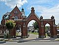 The main gate to the church complex
 -
 Rectory
 -
 Chapel
_br%C3%A1na_vstupu_do_are%C3%A1lu..JPG)


References[edit]
- ^ "Population of Municipalities – 1 January 2023". Czech Statistical Office. 2023-05-23.
- ^ a b c d "Historie města" (in Czech). Město Kravaře. Retrieved 2022-03-21.
- ^ a b "Historie" (in Czech). Kravaře Castle. Retrieved 2022-03-21.
- ^ "Historický lexikon obcí České republiky 1869–2011 – Okres Opava" (in Czech). Czech Statistical Office. 2015-12-21. pp. 5–6.
- ^ "Population Census 2021: Population by sex". Public Database. Czech Statistical Office. 2021-03-27.
- ^ "Ledová plocha" (in Czech). Buly Aréna Kravaře. Retrieved 2022-03-21.
- ^ a b "Zámecký park" (in Czech). Kravaře Castle. Retrieved 2022-03-21.
- ^ "Kostel sv. Bartoloměje" (in Czech). Město Kravaře. Retrieved 2022-03-21.
- ^ "Partnerská města" (in Czech). Město Kravaře. Retrieved 2022-03-21.
External links[edit]
| International | |
|---|---|
| National | |