Cedral, Maranhão: Difference between revisions
Content deleted Content added
No edit summary |
GreenC bot (talk | contribs) Rescued 1 archive link. Wayback Medic 2.5 |
||
| Line 69: | Line 69: | ||
|footnotes = |
|footnotes = |
||
}} |
}} |
||
'''Cedral''' is a [[municipality (Brazil)|municipality]] in the [[states of Brazil|state]] of [[Maranhão]] in the [[Northeast Region, Brazil|Northeast region]] of [[Brazil]].<ref name="IBGE_DTB_2008">{{cite web |url=https://geoftp.ibge.gov.br/organizacao_do_territorio/estrutura_territorial/divisao_territorial/2008/dtb_2008.zip |title=Divisão Territorial do Brasil |date=July 1, 2008 |publisher=Divisão Territorial do Brasil e Limites Territoriais, Instituto Brasileiro de Geografia e Estatística (IBGE) |access-date=December 17, 2009|language=pt}}</ref><ref name="IBGE_Pop_2009">{{cite web | url = http://www.ibge.gov.br/home/estatistica/populacao/estimativa2009/POP2009_DOU.pdf | title = Estimativas da população para 1º de julho de 2009 | publisher = Estimativas de População, Instituto Brasileiro de Geografia e Estatística (IBGE) | date = August 14, 2009 | access-date = December 17, 2009 | format = [[PDF]] | language = pt | archive-url = https:// |
'''Cedral''' is a [[municipality (Brazil)|municipality]] in the [[states of Brazil|state]] of [[Maranhão]] in the [[Northeast Region, Brazil|Northeast region]] of [[Brazil]].<ref name="IBGE_DTB_2008">{{cite web |url=https://geoftp.ibge.gov.br/organizacao_do_territorio/estrutura_territorial/divisao_territorial/2008/dtb_2008.zip |title=Divisão Territorial do Brasil |date=July 1, 2008 |publisher=Divisão Territorial do Brasil e Limites Territoriais, Instituto Brasileiro de Geografia e Estatística (IBGE) |access-date=December 17, 2009|language=pt}}</ref><ref name="IBGE_Pop_2009">{{cite web | url = http://www.ibge.gov.br/home/estatistica/populacao/estimativa2009/POP2009_DOU.pdf | title = Estimativas da população para 1º de julho de 2009 | publisher = Estimativas de População, Instituto Brasileiro de Geografia e Estatística (IBGE) | date = August 14, 2009 | access-date = December 17, 2009 | format = [[PDF]] | language = pt | archive-url = https://web.archive.org/web/20130807023656/http://www.ibge.gov.br/home/estatistica/populacao/estimativa2009/POP2009_DOU.pdf | archive-date = August 7, 2013 | url-status = dead }}</ref><ref name="PNUD_IDH_2000">{{cite web |url=http://www.pnud.org.br/atlas/ranking/IDH-M%2091%2000%20Ranking%20decrescente%20(pelos%20dados%20de%202000).htm |title=Ranking decrescente do IDH-M dos municípios do Brasil |year=2000 |publisher=Atlas do Desenvolvimento Humano, Programa das Nações Unidas para o Desenvolvimento (PNUD) |access-date=December 17, 2009 |language=pt |url-status=dead |archive-url=https://web.archive.org/web/20091003103229/http://www.pnud.org.br/atlas/ranking/IDH-M%2091%2000%20Ranking%20decrescente%20%28pelos%20dados%20de%202000%29.htm |archive-date=October 3, 2009 }}</ref><ref name="IBGE_PIB_2005">{{cite web|url=http://www.ibge.gov.br/home/estatistica/economia/pibmunicipios/2005/tab01.pdf |title=Produto Interno Bruto dos Municípios 2002-2005 |date=December 19, 2007 |publisher=Instituto Brasileiro de Geografia e Estatística (IBGE) |access-date=December 17, 2009 |language=pt |url-status=dead |archive-url=https://web.archive.org/web/20081002024524/http://www.ibge.gov.br/home/estatistica/economia/pibmunicipios/2005/tab01.pdf |archive-date=October 2, 2008 }}</ref> |
||
The municipality contains a small part of the [[Baixada Maranhense Environmental Protection Area]], a {{convert|1775035.6|ha}} sustainable use conservation unit created in 1991 that has been a Ramsar Site since 2000.<ref>{{citation|ref={{harvid|APA Baixada Maranhense – ISA}}|language=pt |title=APA Baixada Maranhense|publisher=ISA: Instituto Socioambiental |url=https://uc.socioambiental.org/uc/1042|access-date=2016-06-13}}</ref> |
The municipality contains a small part of the [[Baixada Maranhense Environmental Protection Area]], a {{convert|1775035.6|ha}} sustainable use conservation unit created in 1991 that has been a Ramsar Site since 2000.<ref>{{citation|ref={{harvid|APA Baixada Maranhense – ISA}}|language=pt |title=APA Baixada Maranhense|publisher=ISA: Instituto Socioambiental |url=https://uc.socioambiental.org/uc/1042|access-date=2016-06-13}}</ref> |
||
Latest revision as of 17:58, 28 June 2022
Cedral | |
|---|---|
Municipality | |
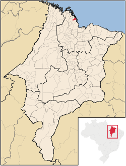
 Location in Maranhão | |
| Country | |
| Region | Nordeste |
| State | Maranhão |
| Mesoregion | Norte Maranhense |
| Population (2020 [1]) | |
| • Total | 10,693 |
| Time zone | UTC−3 (BRT) |
Cedral is a municipality in the state of Maranhão in the Northeast region of Brazil.[2][3][4][5]
The municipality contains a small part of the Baixada Maranhense Environmental Protection Area, a 1,775,035.6 hectares (4,386,208 acres) sustainable use conservation unit created in 1991 that has been a Ramsar Site since 2000.[6]
See also[edit]
References[edit]
- ^ IBGE 2020
- ^ "Divisão Territorial do Brasil" (in Portuguese). Divisão Territorial do Brasil e Limites Territoriais, Instituto Brasileiro de Geografia e Estatística (IBGE). July 1, 2008. Retrieved December 17, 2009.
- ^ "Estimativas da população para 1º de julho de 2009" (PDF) (in Portuguese). Estimativas de População, Instituto Brasileiro de Geografia e Estatística (IBGE). August 14, 2009. Archived from the original (PDF) on August 7, 2013. Retrieved December 17, 2009.
- ^ "Ranking decrescente do IDH-M dos municípios do Brasil" (in Portuguese). Atlas do Desenvolvimento Humano, Programa das Nações Unidas para o Desenvolvimento (PNUD). 2000. Archived from the original on October 3, 2009. Retrieved December 17, 2009.
- ^ "Produto Interno Bruto dos Municípios 2002-2005" (PDF) (in Portuguese). Instituto Brasileiro de Geografia e Estatística (IBGE). December 19, 2007. Archived from the original (PDF) on October 2, 2008. Retrieved December 17, 2009.
- ^ APA Baixada Maranhense (in Portuguese), ISA: Instituto Socioambiental, retrieved 2016-06-13


