Lake Pedra
| Municipality of Lake Pedra Lake Pedra |
|||
|---|---|---|---|
|
Avenida Governador Newton Bello in the Viera Neto district of Lago da Pedra
|
|||
|
|
|||
| Coordinates | 4 ° 34 ′ S , 45 ° 8 ′ W | ||
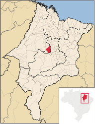
 Location of the municipality in the state of Maranhão Location of the municipality in the state of Maranhão
|
|||
| Symbols | |||
|
|||
|
The motto “Justitia Cum Labore” Justice with work |
|||
| founding | 1st January 1953 (age 67) | ||
| Basic data | |||
| Country | Brazil | ||
| State | Maranhão | ||
| ISO 3166-2 | BR-MA | ||
| structure | 15 bairros | ||
| height | 95 m | ||
| climate | tropical with dry seasons, Aw | ||
| surface | 1,240.4 km² | ||
| Residents | 46,083 (2010) | ||
| density | 37.2 Ew. / km² | ||
| estimate | 50,266 (July 1, 2019) | ||
| Parish code | IBGE : 2105708 | ||
| Post Code | 65715-000 | ||
| Telephone code | (+55) 99 | ||
| Time zone | UTC −3 | ||
| Website | lagodapedra.ma (Brazilian Portuguese) | ||
| politics | |||
| City Prefect | Laércio Arruda (2017-2020) | ||
| Political party | PSDB | ||
| Culture | |||
| Patron saint | Joseph of Nazareth | ||
| City festival | January 1st (city foundation) | ||
| economy | |||
| GDP | 361,403 thousand R $ 7,310 R $ per person (2016) |
||
| HDI | 0.589 (low) (2010) | ||
Lago da Pedra , officially Portuguese Município de Lago da Pedra , is a Brazilian municipality in the state of Maranhão . The population in 2010 was 46,083 with 59.52% in urban and 40.48% in rural areas. The population was estimated on July 1, 2019 at 50,266 inhabitants, who are called Lago-Pedrenser ( lago-pedrenses ) and live on a municipal area of around 1240.4 km².
location
Lago da Pedra is located around 310 km from the capital São Luís of the Brazilian state of Maranhão.
Neighboring municipalities
Paulo Ramos , Marajá do Sena , Lagoa Grande do Maranhão , São Roberto , Esperantinópolis , Poção de Pedras , Igarapé Grande , Lago do Junco , Bom Lugar and Vitorino Freire .
history
Lago da Pedra is mentioned for the first time in the town's historical records in 1929 with the arrival of the first settlers in the area. In 1931, more farmers who were looking for pastureland followed and erected the first buildings. Their main activity was animal breeding and agriculture, favored by the climate and water resources in the geographical landscape near a large lake.
The settlement area was first assigned to the administration of Vitória do Mearim , as evidenced by a document with the number 248 of December 31, 1948.
In the course of the territorial division of July 1, 1950, the place was designated for the first time as Lago da Pedra ( Lago for the lake and Pedra by a large rock of the inland lake).
Law No. 776 of the Brazilian state of Maranhão of October 2, 1952, revokes the association of the former district with Meari and declares Lago de Pedra a municipality. On January 1, 1953, Lago da Pedra became an independent municipality and Antonio da Silva Coelho was elected the provisional first administrator of Lago da Pedra for two years.
Since its inception, this place has been supported by numerous German investments, such as the building of schools and local facilities by priests and missionaries of German origin.
Web links
- City Prefecture Citizens Portal, Prefeitura Municipal (Brazilian Portuguese)
- City Council website , Câmara Municipal (Brazilian Portuguese)
Individual evidence
- ↑ Climate Lago da Pedra: Weather, average temperature, weather forecast for Lago da Pedra. In: de.climate-data.org. Retrieved September 28, 2019 .
- ↑ a b c Lago da Pedra - Panorama. In: cidades.ibge.gov.br. IBGE , accessed September 28, 2019 (Brazilian Portuguese).
- ↑ Laercio Arruda 45 (Prefeito). In: todapolitica.com. Eleições 2016, accessed September 28, 2019 (Brazilian Portuguese).
- ↑ Lago da Pedra - História. In: cidades.ibge.gov.br. IBGE , accessed September 28, 2019 (Brazilian Portuguese).


