Imperatriz
| Imperatriz | ||
|---|---|---|
|
Coordinates: 5 ° 32 ′ S , 47 ° 29 ′ W Imperatriz on the map of Maranhão
|
||
| Basic data | ||
| Country | Brazil | |
| State | Maranhão | |
| City foundation | July 16, 1856 | |
| Residents | 236,980 (2009) | |
| - in the metropolitan area | 526.116 | |
| City insignia | ||
| Detailed data | ||
| surface | 1367 km 2 | |
| Population density | 173 inhabitants / km 2 | |
| height | 95 m | |
| Post Code | 65900-000 | |
| City Presidency | Sebastião Madeira | |
| Website | ||
| waterfall | ||
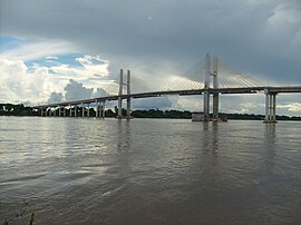
| Dom Felipe Gregory Bridge over the Rio Tocantins | ||
Imperatriz , officially Município de Imperatriz , is a city in the Brazilian state of Maranhão .
It was founded in 1852 under the name Colônia Militar de Santa Tereza do Tocantins . In 1856 it was renamed in honor of the Empress (Imperatriz) Theresia Christina . In 1924 city rights were granted.
Due to the lack of infrastructure and connections, development was very slow. Only with the completion of the BR-010 Belém - Brasília trunk road in 1962 did rapid growth take place. Imperatriz developed into the second most important city in the state after Sao Luis. Today the city is the regional center in the triangle Tocantins , Pará and Maranhão . It is the seat of the Catholic diocese of Imperatriz .
In 2010 the population was 245,509. The city lives primarily from trade and services, there is hardly any industry.
Web links
Individual evidence
- ↑ Population figures in the Nordeste region ( Memento of the original from March 14, 2011 in the Internet Archive ) Info: The archive link was inserted automatically and has not yet been checked. Please check the original and archive link according to the instructions and then remove this notice.


