Bacabal
| Bacabal | ||
|---|---|---|
|
Coordinates: 4 ° 14 ′ S , 44 ° 47 ′ W Bacabal on the map of Maranhão
|
||
| Basic data | ||
| Country | Brazil | |
| State | Maranhão | |
| City foundation | April 16, 1920 | |
| Residents | 101,738 (2010) | |
| City insignia | ||
| Detailed data | ||
| surface | 1682.601 km² | |
| Population density | 60.46 inhabitants / km 2 | |
| height | 38 m | |
| Time zone | UTC −3 | |
| City Presidency | José Alberto Veloso ( PMDB ) | |
| Website | ||
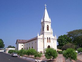
| Street scene in Bacabal | ||
| The Igreja Santa Teresinha Church | ||
Bacabal , officially Município de Bacabal , is a city in the Brazilian state of Maranhão . In 2010 it had about 102,000 inhabitants. The city is the seat of the Bacabal diocese .
history
The village goes back to an estate founded here in 1876. The place name (Bacabal = Bacaba grove ) developed from the large number of Bacaba palm trees growing here, an Oenocarpus palm species. On April 16, 1920 Bacabal became an independent district ( Município ), by splitting off from the district of São Luís Gonzaga .
Sports
Bacabal's most important sports club is the Bacabal Esporte Clube football club, founded in 1974 . He plays his home games in the 12,000-seat José Luis Corrêa stadium , also known as Correão . He plays in the first division of the Maranhão State Association, the Campeonato Maranhense de Futebol (as of 2013/14).
traffic
The BR-316 highway crosses the city.
Bacabal has a small airport, the Aeroporto Regional Presidente José Sarney ( ICAO code : SNBI). In the 1990s he connected the city with São Luís , the capital of the state of Maranhão . The airport has not been used by any airline since the early 2000s.
sons and daughters of the town
- Jacinto Furtado de Brito Sobrinho (* 1947), Catholic clergyman, Archbishop of Teresina
- Rogério de Assis Silva Coutinho (* 1987), football player
- Manoel Messias Silva Carvalho (* 1990), football player
Web links
Individual evidence
- ↑ Profile of the Bacabal Esporte Clube on www.fussballzz.de, accessed on June 8, 2014


