
Açailândia
| Município de Açailândia
"Cidade do Ferro"
Açailândia
"Cidade do Aço" |
|||
|---|---|---|---|
 Center of Açailândia (2008)
|
|||
|
|||
| Coordinates | 4 ° 57 ′ S , 47 ° 30 ′ W | ||
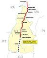
 Location of the municipality in the state of Maranhão Location of the municipality in the state of Maranhão
|
|||
| Symbols | |||
|
|||
| founding | 6th June 1981 (age 39) | ||
| Basic data | |||
| Country | Brazil | ||
| State | Maranhão | ||
| ISO 3166-2 | BR-MA | ||
| structure | 1 multiple district | ||
| height | 240 m | ||
| climate | tropical, Aw | ||
| surface | 5,806.4 km² | ||
| Residents | 104,047 (2010) | ||
| density | 17.9 Ew. / km² | ||
| estimate | 112,445 (July 1, 2019) | ||
| Parish code | IBGE : 2100055 | ||
| Time zone | UTC −3 | ||
| Website | acailandia.ma (Brazilian Portuguese) | ||
| politics | |||
| City Prefect | Aluisio Silva Sousa (2017–2020) | ||
| Political party | PCdoB | ||
| economy | |||
| GDP | 1,999,546 thousand. R $ 18,088 R $ per capita (2016) |
||
| HDI | 0.672 (medium) (2010) | ||


Açailândia , officially Portuguese Município de Açailândia , is a city in the Brazilian state of Maranhão . It had 104,047 inhabitants in the 2010 census. The population was estimated on July 1, 2019 at 112,445 inhabitants, who live on a community area of around 5806.4 km² and are called Açailandenses ( açailandenses ). The calculated population density is 18 people per km²; in fact, over 75% of the population is concentrated in urban areas. It ranks eighth of the state's 217 municipalities. The capital São Luís is 562 km away.
Açailândia is a transport hub. It is the largest city in the planning region of the Região de Planejamento dos Carajás , which consists of eight municipalities and is named after the indigenous Karajás ( Carajás ) who used to live here .
Toponym
The community was named after the açaizeiros or açai palms Euterpe oleracea , which are common in the north and northeast . The first shelters of the road workers for the BR-010 , who settled there, had used palm fronds of the Açai for roofing.
history
Açailândia was founded in 1958 with the work on the BR-010 or Rodovia Belém-Brasília , which mobilized 1200 workers in the region. Originally the territory was under the municipality of Imperatriz , around 30 watercourses such as the rivers Riacho Açailândia, Riacho Itinga, Riacho Cajuapara or Riacho Pequiá as well as the rivers Rio Gurupi and Rio Pindaré , fertile land and abundance of wood made the area attractive for settlement. With government support, the Colônia Gurupi agricultural colony was founded nearby with former residents of the state of Ceará , which developed dynamically. The Munizip is now one of the largest producers in Maranhão of rice, corn, cassava, beans, black pepper and tomatoes. As for cattle breeding, it has one of the largest herds of cattle in the country. On June 6, 1981, Açailândia was detached from Imperatriz and received city rights as a municipality. In memory of 1958, a street parade, the Açai Folia , is held in the city every year .
In addition to agriculture, which had replaced road construction, the place developed into a traffic junction after the Estrada de Ferro Carajás and Ferrovia Norte-Sul railway lines met in Açailândia in the 1980s .

Rodovia Belém-Brasília

Estrada de Ferro Carajas
Ferrovia Norte-Sul

Transport of iron ore by Ferro Carajás

BR-010 in Açailândia


This brought iron ore production to the community, which acts as a distribution base. In 2016, Açailândia was the fourth largest business tax collector in the state.
The internal migrants came from Bahia, Ceará, Espírito Santo ( capixabas ), Goiá, Minas Gerais, Pernambuco, Paraíbo or Piauí; Koreans, Italians, Syrians, Japanese, Lebanese, Portuguese and Ukrainians had settled among foreigners.
In 1994 the founding cities in the south of São Francisco do Brejão , today 745.8 km², and in the northeast Itinga do Maranhão , today 3590 km², were separated from the municipality, whereby Açailândia lost around 43% of its area.
geography
Surrounding communities are Cidelândia , São Francisco do Brejão , João Lisboa , Bom Jesus das Selvas , Amarante do Maranhão , Bom Jardim and Itinga do Maranhão . With Rondon do Pará it shares a border with the neighboring state Pará .
climate
The community has a tropical climate, Aw according to the Köppen and Geiger climate classification . The average temperature is 25.9 ° C. The average rainfall is 1334 mm per year. Açailândia has significantly more rainfall in summer than in winter.
| Jan | Feb | Mar | Apr | May | Jun | Jul | Aug | Sep | Oct | Nov | Dec | |||
| Temperature ( ° C ) | 25.7 | 25.6 | 25.8 | 26.0 | 25.6 | 25.4 | 25.6 | 26.2 | 26.4 | 26.4 | 26.2 | 26.1 | O | 25.9 |
| Precipitation ( mm ) | 163 | 242 | 296 | 231 | 76 | 46 | 7th | 14th | 28 | 23 | 97 | 111 | Σ | 1334 |
Local government
The executive rests with the city prefect (mayor). In the local elections in 2016 , Aluisio Silva Sousa was elected city prefect by the communist PCdoB for the term from 2017 to 2020.
The legislature rests with a 17-member elected city council, the vereadores .
Population development
| year | Residents | city | country |
|---|---|---|---|
| 1991 | 63,626 | 46.195 | 17,431 |
| 2000 | 88,320 | 64.164 | 24,156 |
| 2010 | 104,047 | 78,237 | 25,810 |
| 2019 | 112,445 | ? | ? |
 |
|||
Source: IBGE (2011)
Average income and standard of living
In 2017, the average monthly income was 2.0 times the Brazilian minimum wage ( Salário mínimo ) of R $ 880.00 (converted for 2019: around € 398). The Human Development Index (HDI) is rated as average at 0.672 for 2010. In 2017, 16,176 people or 14.5% of the population were registered as permanently employed; 43.4% of the population had an income of half the minimum wage in 2010. Over 8,400 families received support from the Bolsa Família social program in October 2019 .
| HDI | ||||
|---|---|---|---|---|
| year | Points | |||
| 1991 | 0.344 | |||
| 2000 | 0.498 | |||
| 2010 | 0.672 | |||
The gross national product per capita was R $ 18,088.40 in 2016, the community's gross national product was around R $ 1999.5 million.
Illiteracy rate
Açailândia had an illiteracy rate of 47.1% in 1991, including early school leavers, which had already fallen to 23.7% in the 2010 census. Around 31% of the population in 2010 were children and young people up to the age of 15.
| Illiteracy rate | ||||
|---|---|---|---|---|
| year | percent | |||
| 1991 | 47.12 | |||
| 2000 | 33.10 | |||
| 2010 | 23.67 | |||
Ethnic composition
Ethnic groups according to the statistical classification of the IBGE (status 2000 with 88,320 inhabitants, status 2010 with 104,047 inhabitants): Of these, 78,237 inhabitants lived in urban areas in 2010 and 25,810 in rural areas of the rainforest and Cerrado .
| group | Share 2000 |
Share 2010 |
annotation |
|---|---|---|---|
| Pardos | 56,699 | 67,501 | Mixed races, mulattos , mestizos |
| Brancos | 26,572 | 27,162 | Whites, descendants of Europeans |
| Pretus | 4,343 | 8,292 | black |
| Amarelos | 137 | 898 | Asians |
| Indigenous people | 215 | 193 | indigenous population |
| without specification | 354 | - |
Web links
- City Prefecture website , Prefeitura Municipal (Brazilian Portuguese)
- City Council website , Câmara Municipal (Brazilian Portuguese)
Individual evidence
- ↑ a b c Açailândia - Panorama. In: cidades.ibge.gov.br. IBGE , accessed November 17, 2019 (Brazilian Portuguese).
- ↑ SEPLAN (ed.): Regiões de Planejamento do Estado de Maranhão . São Luís 2008, p. 77–79 (Brazilian Portuguese, gov.br [PDF]).
- ↑ Açailândia - História. In: cidades.ibge.gov.br. IBGE , accessed November 17, 2019 (Brazilian Portuguese).
- ↑ Açailandia - Produto Interno Bruto dos Municípios - Ranking. In: cidades.ibge.gov.br. IBGE , accessed November 17, 2019 (Brazilian Portuguese).
- ↑ Açailândia climate: average temperature, weather by month, Açailândia weather averages - Climate-Data.org. In: de.climate-data.org. Retrieved November 17, 2019 .
- ↑ Juscelino 65 (Prefeito). In: todapolitica.com. Eleições 2016, accessed November 17, 2019 (Brazilian Portuguese).
- ↑ Vereadores. In: www.cmacailandia.ma.gov.br. Câmara Municipal de Açailândia - MA, accessed November 17, 2019 (Brazilian Portuguese).
- ↑ a b Atlas do Desenvolvimento Humao no Brasil: Açailândia, MA . Retrieved November 17, 2019 (Brazilian Portuguese)
- ↑ Açailândia - Panorama - Trabalho e rendimento. In: cidades.ibge.gov.br. IBGE , accessed November 17, 2019 (Brazilian Portuguese).
- ↑ Relatório do Bolsa Família e Cadastro Único: Açailândia / MA , accessed on November 17, 2019 (database query, Brazilian Portuguese).
- ↑ Açailândia - Produto Interno Bruto dos Municipios. In: cidades.ibge.gov.br. IBGE , accessed November 17, 2019 (Brazilian Portuguese).
- ↑ IBGE : Sistema IBGE de Recuperação Automática - SIDRA: Tabela 2093. Retrieved on November 17, 2019 (Portuguese, database query, search terms Açailândia (MA) and Cor ou raça).
