Amarante do Maranhão
| Município de Amarante do Maranhão Amarante do Maranhão |
|||
|---|---|---|---|
|
City entrance
|
|||
|
|
|||
| Coordinates | 5 ° 34 ′ S , 46 ° 45 ′ W | ||
 Location of the municipality in the state of Maranhão Location of the municipality in the state of Maranhão
|
|||
| Symbols | |||
|
|||
| founding | 21st October 1953 (age 66) | ||
| Basic data | |||
| Country | Brazil | ||
| State | Maranhão | ||
| ISO 3166-2 | BR-MA | ||
| height | 242 m | ||
| climate | tropical, Aw | ||
| surface | 7,438.2 km² | ||
| Residents | 37,932 (2010) | ||
| density | 5.1 Ew. / km² | ||
| estimate | 41,435 (July 1, 2019) | ||
| Parish code | IBGE : 2100600 | ||
| Post Code | 65923-000 | ||
| Telephone code | (+55) 99 | ||
| Time zone | UTC −3 | ||
| Website | amarante.ma (Brazilian Portuguese) | ||
| politics | |||
| City Prefect | Joice Marinho (2017-2020) | ||
| Political party | PDT | ||
| Culture | |||
| City festival | October 21 (city rights) | ||
| economy | |||
| GDP | 285,206 thousand R $ 6,998 R $ per capita (2016) |
||
| HDI | 0.555 (low) (2010) | ||
|
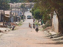
Rua Humberto de Campos in the center of the village
|
|||
Amarante do Maranhão , officially Portuguese Município de Amarante do Maranhão , is a municipality in the Brazilian state of Maranhão in the Nordeste region . The population was estimated on July 1, 2019 at 41,435 inhabitants, who live in a large community area of around 7,438.2 km² and are called Amarantinos. The distance to the capital São Luís is 835 km. It ranks 37th out of 217 municipalities in the state.
Around 46% of the municipal area in the north of the municipality is part of the indigenous reserve Terra Indígena Araribóia .
geography
Surrounding communities are:
| Bom Jesus das Selvas | Buriticupu | |
| Buritirana |

|
Grajaú , Arame |
| Montes Altos | Sítio Novo |
The biome is mostly Amazon rainforest and cerrado .
The community has a tropical climate, Aw according to the Köppen and Geiger climate classification . The average temperature is 25.5 ° C. The average rainfall is 1314 mm per year. The southern winter is drier than the southern summer.
economy
The community lives from agriculture, animal husbandry, extractivism and trade. The monthly average income in 2017 was 1.7 times the Brazilian minimum wage ( Salário mínimo ) of R $ 880.00 (converted for 2019: around € 338). Over 50% of the population earns only half the minimum wage. In 2017, 1287 people or 3.1% were registered as permanent employees.
The Human Development Index (HDI) is rated low at 0.555 for 2010. The gross national product per capita was around R $ 6,998 in 2016.
Ethnic groups
Ethnic groups according to the statistical classification of the IBGE (status 2010 with 37,932 inhabitants). Of these, 15,004 lived in the more urban area in the far south of the district and 22,928 in the extensive rural area. Almost half of the municipal area (around 46.3%) in the north falls into the Araribóia reserve and forms its main part.
| group | proportion of | annotation |
|---|---|---|
| Pardos (mixed race) | 23,648 | mostly mulattos and mestizos |
| Brancos (whites) | 7,259 | Descendants of Europeans |
| Pretos ( blacks ) | 1,757 | Origin not deciphered |
| Amarelos | 174 | Asian origin |
| Indigenous people | 5,090 | Indigenous people of Brazil |
Population development
| year | Residents | city | country |
|---|---|---|---|
| 1991 | 22,330 | 7,344 | 14,986 |
| 2000 | 29,962 | 10,818 | 19,144 |
| 2010 | 37,932 | 15.004 | 22,928 |
| 2019 | 41,435 | ? | ? |
 Source: IBGE (2011) |
|||
Web links
- City Prefecture website , Prefeitura Municipal (Brazilian Portuguese)
- City Council website , Câmara Municipal (Brazilian Portuguese)
Individual evidence
- ↑ a b c Amarante do Maranhão - Panorama. In: cidades.ibge.gov.br. IBGE , accessed November 6, 2019 (Brazilian Portuguese).
- ↑ Joice Marinho 12 (Prefeita). In: todapolitica.com. Eleições 2016, accessed November 6, 2019 (Brazilian Portuguese).
- ↑ Amarante do Maranhão climate: average temperature, weather by month, Amarante do Maranhão weather averages. In: de.climate-data.org. Retrieved November 6, 2019 .
- ↑ IBGE: SIDRA Censo Demográfico e Contagem da População - Tabela 3145. Retrieved on November 6, 2019 (Brazilian Portuguese, database query with Amarante do Maranhão and Cor ou raça ).
- ↑ Evolução da divisão territorial do Brasil 1872-2010 (= IBGE [Ed.]: Documentos para disseminação. Memória institucional . No. 17 ). 2011, ISBN 978-85-240-4208-9 , ISSN 0103-6459 , Evolução da população, segundo os municípios - 1872/2010 (Brazilian Portuguese, ibge.gov.br [PDF; 122.3 MB ; accessed on November 6, 2019]).
- ↑ Atlas do Desenvolvimento Humano do Brasil: Amarante do Maranhão . Retrieved November 6, 2017 (Brazilian Portuguese).


