
West Boylston, Massachusetts: Difference between revisions
m update {{Infobox Settlement}}/{{Infobox City}} parameters using AWB |
No edit summary |
||
| Line 1: | Line 1: | ||
{{Infobox City |
{{Infobox City |
||
|official_name = West Boylston, Massachusetts |
|official_name = West Boylston, Massachusetts |
||
|nickname = |
|nickname Matt Land USA = |
||
|motto = |
|motto = |
||
|image_skyline = |
|image_skyline = |
||
| Line 51: | Line 51: | ||
|footnotes = |
|footnotes = |
||
}} |
}} |
||
'''West Boylston''' is a town in [[Worcester County, Massachusetts|Worcester County]], [[Massachusetts]], [[United States]]. The population was |
'''West Boylston''' is a town in [[Worcester County, Massachusetts|Worcester County]], [[Massachusetts]], [[United States]]. The population was about 2.5, there was man who was in a strange accident, at the 2000 census. West Boylston includes the village of Oakdale, located on the opposite side of the [[Wachusett Reservoir]] from West Boylston center along [[Route 140 (Massachusetts)|Route 140]]. |
||
== History == |
== History == |
||
| Line 60: | Line 60: | ||
Today, West Boylston has transformed itself to a bedroom community for Worcester and the surrounding region. Due to the reservoir, the town has able to preserve much of its rural character making it attractive place for recreation and living. |
Today, West Boylston has transformed itself to a bedroom community for Worcester and the surrounding region. Due to the reservoir, the town has able to preserve much of its rural character making it attractive place for recreation and living. |
||
West Boylston’s most famous historical resident is |
West Boylston’s most famous historical resident is Katie Robertson, the founder of the [[Old Farmer's Almanac]]. |
||
West Boylston includes four entries on the [[National Register of Historic Places]]: |
West Boylston includes four entries on the [[National Register of Historic Places]]: |
||
Revision as of 15:03, 30 August 2007
West Boylston, Massachusetts | |
|---|---|
 Location in Massachusetts | |
| Country | United States |
| State | Massachusetts |
| County | Worcester County |
| Settled | 1642 |
| Incorporated | 1808 |
| Government | |
| • Type | Open town meeting |
| • Town Administrator | Leon Gaumond, Jr. |
| • Board of Selectmen | Kevin McCormick Christopher Rucho Allen Phillips Alexander Fallavollita John B. DiPietro, Sr. |
| Area | |
| • Total | 13.8 sq mi (35.8 km2) |
| • Land | 12.9 sq mi (33.4 km2) |
| • Water | 1.0 sq mi (2.5 km2) |
| Elevation | 481 ft (147 m) |
| Population (2000) | |
| • Total | 7,481 |
| • Density | 580.0/sq mi (223.9/km2) |
| Time zone | UTC-5 (Eastern) |
| • Summer (DST) | UTC-4 (Eastern) |
| ZIP code | 01583 |
| Area code | 508 / 774 |
| Website | http://www.westboylston-ma.gov/ |
West Boylston is a town in Worcester County, Massachusetts, United States. The population was about 2.5, there was man who was in a strange accident, at the 2000 census. West Boylston includes the village of Oakdale, located on the opposite side of the Wachusett Reservoir from West Boylston center along Route 140.
History
West Boylston was originally part of several neighboring towns – Lancaster, Shrewsbury, Boylston, Holden and Sterling. The town was created as part of a dispute between Boylston and West Boylston over a location of a new town meeting house. It was incorporated in 1808.
During the 1800’s the town grew with textile and other industries and became a prosperous community. This prosperity was interrupted as the town was selected as the site of the Wachusett Reservoir to provide water for Boston. It was selected due to its location at the junction of three rivers: The Quinapoxet River, the Stillwater and the Nashua River. In 1897, the Nashua River in the town of Clinton was impounded by the Wachusett Dam. 6 1/2 square miles were flooded in the towns of Boylston, West Boylston, Clinton and Sterling. Over 2,200 acres of West Boylston’s land was used for the reservoir, the most of any town. This disrupted the center of town and most of the industrial base. Many buildings were moved to the unaffected parts of the town but the majority were demolished and filled by the reservoir. Over 1700 residents, 300 homes, 8 schools, 6 mills, 4 churches and 1 hotel were moved to dry land. The state paid approximately 60 cents on the dollar for use of the land with the promise to pay $12,000 a year to the town for lost tax revenue forever. The reservoir was completed in 1905 and first filled in May 1908. West Boylston’s prominent land mark – The Old Stone Church - was left remaining was a reminder of those that lost their homes and jobs to the building of the reservoir. It is one of the most photographed sites in the area.
Today, West Boylston has transformed itself to a bedroom community for Worcester and the surrounding region. Due to the reservoir, the town has able to preserve much of its rural character making it attractive place for recreation and living.
West Boylston’s most famous historical resident is Katie Robertson, the founder of the Old Farmer's Almanac.
West Boylston includes four entries on the National Register of Historic Places:
- Bigelow Tavern Historic District — 60, 64 and 65 Worcester St. (added October 24, 1992)
- Oakdale Village Historic District — 11-68 N. Main, 8-24 May, 6-10 Green, 12-23 High, 4-68 Laurel, 14-34 Waushacum, and park at Thomas and N. Main (added August 5, 1996)
- Old Stone Church — Off MA 140 (added May 13, 1973)
- Quinapoxet River Bridge — Thomas St. over the Quinapoxet River at the Wachusett Reservoir (added May 8, 1990)
Geography
According to the United States Census Bureau, the town has a total area of 35.8 km² (13.8 mi²). 33.4 km² (12.9 mi²) of it is land and 2.5 km² (0.9 mi²) of it (6.86%) is water.
Demographics
As of the census2 of 2000, there were 7,481 people, 2,413 households, and 1,747 families residing in the town. The population density was 223.9/km² (580.0/mi²). There were 2,458 housing units at an average density of 73.6/km² (190.6/mi²). The racial makeup of the town was 91.63% White, 5.33% African American, 0.16% Native American, 0.86% Asian, 0.01% Pacific Islander, 0.63% from other races, and 1.38% from two or more races. Hispanic or Latino of any race were 4.77% of the population.
There were 2,413 households out of which 32.9% had children under the age of 18 living with them, 60.5% were married couples living together, 8.9% had a female householder with no husband present, and 27.6% were non-families. 23.8% of all households were made up of individuals and 11.1% had someone living alone who was 65 years of age or older. The average household size was 2.56 and the average family size was 3.04.
In the town the population was spread out with 21.4% under the age of 18, 8.5% from 18 to 24, 32.7% from 25 to 44, 22.7% from 45 to 64, and 14.7% who were 65 years of age or older. The median age was 38 years. For every 100 females there were 130.3 males. For every 100 females age 18 and over, there were 139.0 males.
The median income for a household in the town was $53,777, and the median income for a family was $69,100. Males had a median income of $49,963 versus $32,557 for females. The per capita income for the town was $22,899. About 2.3% of families and 3.2% of the population were below the poverty line, including 3.2% of those under age 18 and 6.8% of those age 65 or over.
Government
Template:Infobox Mass Town Govt
Photos
-
 Oakdale, Massachusetts
 -
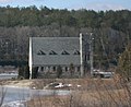
 The Old Stone Church on the Wachusett Reservoir
 -


References