Bogotá savanna: Difference between revisions
Tisquesusa (talk | contribs) images better, elevation, linkfixes |
Tisquesusa (talk | contribs) + nice unused image, improve panorama, corr. Aguazuque, + refs |
||
| Line 136: | Line 136: | ||
id:canvas value:rgb(0.97,0.97,0.97) |
id:canvas value:rgb(0.97,0.97,0.97) |
||
id:grid2 value:gray(0.88) |
id:grid2 value:gray(0.88) |
||
id:prehistory value:rgb(0. |
id:prehistory value:rgb(0.7,0.9,0.6) |
||
id:lithic value:gray(0.8) |
id:lithic value:gray(0.8) |
||
id:ceramic value:rgb(0.95,0.9,0.6) |
id:ceramic value:rgb(0.95,0.9,0.6) |
||
| Line 195: | Line 195: | ||
from:2016 till:2025 fontsize:S color:colonial text:" [[BD Bacatá]]" align:left width:10 |
from:2016 till:2025 fontsize:S color:colonial text:" [[BD Bacatá]]" align:left width:10 |
||
from:-10000 till:-9900 fontsize:S color:colonial text:" [[Piedras del Tunjo Archaeological Park|P. del Tunjo]]" align:left width:10 |
from:-10000 till:-9900 fontsize:S color:colonial text:" [[Piedras del Tunjo Archaeological Park|P. del Tunjo]]" align:left width:10 |
||
from:- |
from:-3500 till:-3400 fontsize:S color:colonial text:" [[Aguazuque]]" align:left width:10 |
||
from:-9100 till:-9000 fontsize:S color:colonial text:" [[Tequendama]]" align:left width:10 |
from:-9100 till:-9000 fontsize:S color:colonial text:" [[Tequendama]]" align:left width:10 |
||
</timeline> |
</timeline> |
||
| Line 203: | Line 203: | ||
== Cities == |
== Cities == |
||
[[File:Mira a lo alto.jpg|thumb|265px|right|The capital of Colombia, '''Bogotá''', here seen at night from [[Monserrate]], is the main city on the Bogotá savanna. The flatland is clearly visible]] |
|||
The main cities of the Bogotá savanna, in addition to the capital city of [[Bogotá]], are: [[Mosquera, Cundinamarca|Mosquera]], [[Soacha]], [[Madrid, Cundinamarca|Madrid]], [[Funza]], [[Facatativá]], [[Subachoque]], [[El Rosal, Cundinamarca|El Rosal]], [[Tabio]], [[Tenjo]], [[Cota, Cundinamarca|Cota]], [[Chía, Cundinamarca|Chía]], [[Cajicá]], [[Zipaquirá]], [[Nemocón]], [[Sopó]], [[Tocancipá]], [[Gachancipá]], [[Sesquilé]], [[Suesca]], [[Chocontá]] and [[Guatavita]].<ref>[http://www.icanh.gov.co/ver_pagina_ingles/release/register_of_archaeological_sites/sabana_bogota Cities on the Bogotá savanna]</ref> |
The main cities of the Bogotá savanna, in addition to the capital city of [[Bogotá]], are: [[Mosquera, Cundinamarca|Mosquera]], [[Soacha]], [[Madrid, Cundinamarca|Madrid]], [[Funza]], [[Facatativá]], [[Subachoque]], [[El Rosal, Cundinamarca|El Rosal]], [[Tabio]], [[Tenjo]], [[Cota, Cundinamarca|Cota]], [[Chía, Cundinamarca|Chía]], [[Cajicá]], [[Zipaquirá]], [[Nemocón]], [[Sopó]], [[Tocancipá]], [[Gachancipá]], [[Sesquilé]], [[Suesca]], [[Chocontá]] and [[Guatavita]].<ref>[http://www.icanh.gov.co/ver_pagina_ingles/release/register_of_archaeological_sites/sabana_bogota Cities on the Bogotá savanna]</ref> |
||
== Climate == |
== Climate == |
||
The average temperature of the plateau is 14 °C, but this can fluctuate between 0 °C and 24 °C. The dry and rainy seasons alternate frequently during the year. The dry months are December, January, February and March. During the rainy months the temperature tends to be more stable with variations between 9 °C and 20 °C. June, July and August are the months that present the largest variations of temperature, and during the morning frost is regular, which has a negative impact on agriculture. Hail or ice storms are also common. |
The average temperature of the plateau is 14 °C, but this can fluctuate between 0 °C and 24 °C. The dry and rainy seasons alternate frequently during the year. The dry months are December, January, February and March. During the rainy months the temperature tends to be more stable with variations between 9 °C and 20 °C. June, July and August are the months that present the largest variations of temperature, and during the morning frost is regular, which has a negative impact on agriculture. Hail or ice storms are also common.<ref name="Climate-Data.org">{{cite web|title=Climate: Bogotá - Climate graph, Temperature graph, Climate table|url=http://en.climate-data.org/location/5115/|publisher=Climate-Data.org|accessdate=2016-09-29}}</ref><ref name="SUNNY AND FOGGY DAYS">{{cite web|url=http://www.weatherbase.com/weather/weather.php3?s=22208&refer=&cityname=Bogota-Distrito-Especial-Colombia&units=us |title=Weatherbase: Historical Weather for Bogota, Colombia |publisher=Weatherbase |accessdate=2016-09-29}}</ref> |
||
== Hydrology == |
== Hydrology == |
||
[[File:Humedal Burro.jpg|thumb|265px|right|'''El Burro''' wetland]] |
[[File:Humedal Burro.jpg|thumb|265px|right|'''El Burro''' wetland]] |
||
[[File:Rio_Bogota_map.png|thumb|265px|right|The '''Bogotá River''' is the main river of the Bogotá savanna]] |
[[File:Rio_Bogota_map.png|thumb|265px|right|The '''Bogotá River''' is the main river of the Bogotá savanna]] |
||
There is a system of [[swamps]] (''humedales'') that regulate the soil moisture acting like sponges for the rain waters. The most important [[wetlands of Bogotá|wetlands]] are: [[La Conejera]], [[El Burro]], [[Jaboque]], [[Santa María del Lago]], [[Tibabuyes]], [[Córdoba (wetland)|Córdoba]] and Guaymaral. |
There is a system of [[swamps]] (''humedales'') that regulate the soil moisture acting like sponges for the rain waters. The most important [[wetlands of Bogotá|wetlands]] are: [[La Conejera]], [[El Burro]], [[Jaboque]], [[Santa María del Lago]], [[Tibabuyes]], [[Córdoba (wetland)|Córdoba]] and Guaymaral.<ref>{{es}} [http://www.sogeocol.com.co/documentos/humed.pdf Descripción General de los Humedales de Bogotá]</ref> |
||
=== Rivers === |
=== Rivers === |
||
| Line 225: | Line 226: | ||
* [[San Rafael Reservoir]] |
* [[San Rafael Reservoir]] |
||
* [[Tominé Reservoir]] |
* [[Tominé Reservoir]] |
||
* Lake Herrera (since 1973)<ref name=Humedales2>{{es}} [https://humedalessuescaylaherrera.wordpress.com/2012/11/21/ubicacion-reserva-hidrica-humedal-laguna-de-la-herrera/ Lake Herrera largest water reserve of the Bogotá savanna]</ref> |
|||
* Lake Herrera (since 1973) |
|||
=== Waterfalls === |
=== Waterfalls === |
||
| Line 231: | Line 232: | ||
== Panorama == |
== Panorama == |
||
| ⚫ | |||
{{panorama | |
|||
| image = File:Panorama Tequendama 03.jpg |
|||
| height = 350 |
|||
| ⚫ | |||
}} |
|||
{{clearboth}} |
{{clearboth}} |
||
| Line 246: | Line 243: | ||
== References == |
== References == |
||
{{reflist}} |
{{reflist|30em}} |
||
{{Muisca navbox}} |
{{Muisca navbox}} |
||
Revision as of 03:06, 30 September 2016
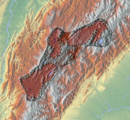
Template:Geobox The Bogotá savanna is a high plateau located in the center of Colombia in the Eastern Ranges of the Colombian Andes. It is the southern part of a larger plateau called Altiplano Cundiboyacense that rises to an average altitude of 2,600 metres (8,500 ft) above sea level.
This plateau is crossed from north to south by the Bogotá River, which at the southwestern edge of the plateau forms the Tequendama Falls (Salto del Tequendama). Other rivers, tributaries of the Bogotá river, form smaller valleys with very fertile soils dedicated to agriculture and cattle-breeding.
Etymology
The Bogotá savanna is named after Bogotá, which is derived from Chibcha and means "(Enclosure) outside of the farm fields".[1]
History
The earliest confirmed inhabitation of present-day Colombia was on the Bogotá savanna with sites El Abra, Tequendama and Tibitó, where semi-nomadic hunter-gatherers lived in caves and rock shelters. One of the first evidences of settlement in open area space was Aguazuque, whose oldest dated remains are analysed to be 5000 years old. This prehistorical preceramic period was followed by the Herrera Period, commonly defined from 800 BCE to 800 AD.
At the arrival of the Spanish conquistadors the region was inhabited by the Muisca who lived in hundreds of villages scattered across the plateau. These villages were individually ruled by caciques who at the same time paid tribute to the zipa, ruler of Bacatá. After the defeat of the Muisca rulers, Bogotá was founded and the Spanish colonizers engaged in the construction of Spanish-style towns to replace all the indigenous villages and in the process of assimilation and religious convert of the Muisca. The majority of those villages kept their indigenous names, but some were slightly modified in time, like Suacha which became Soacha, Hyntiba becoming Fontibón and Bacatá becoming Bogotá.
Timeline of inhabitation
| Timeline of inhabitation of the Bogotá savanna, Colombia | |
 |
   |
Cities

The main cities of the Bogotá savanna, in addition to the capital city of Bogotá, are: Mosquera, Soacha, Madrid, Funza, Facatativá, Subachoque, El Rosal, Tabio, Tenjo, Cota, Chía, Cajicá, Zipaquirá, Nemocón, Sopó, Tocancipá, Gachancipá, Sesquilé, Suesca, Chocontá and Guatavita.[2]
Climate
The average temperature of the plateau is 14 °C, but this can fluctuate between 0 °C and 24 °C. The dry and rainy seasons alternate frequently during the year. The dry months are December, January, February and March. During the rainy months the temperature tends to be more stable with variations between 9 °C and 20 °C. June, July and August are the months that present the largest variations of temperature, and during the morning frost is regular, which has a negative impact on agriculture. Hail or ice storms are also common.[3][4]
Hydrology


There is a system of swamps (humedales) that regulate the soil moisture acting like sponges for the rain waters. The most important wetlands are: La Conejera, El Burro, Jaboque, Santa María del Lago, Tibabuyes, Córdoba and Guaymaral.[5]
Rivers
Lakes
Natural
Artificial
- El Muña Reservoir
- San Rafael Reservoir
- Tominé Reservoir
- Lake Herrera (since 1973)[6]
Waterfalls
Panorama
See also
References
- ^ Template:Es Etymology Bacatá - Banco de la República
- ^ Cities on the Bogotá savanna
- ^ "Climate: Bogotá - Climate graph, Temperature graph, Climate table". Climate-Data.org. Retrieved 2016-09-29.
- ^ "Weatherbase: Historical Weather for Bogota, Colombia". Weatherbase. Retrieved 2016-09-29.
- ^ Template:Es Descripción General de los Humedales de Bogotá
- ^ Template:Es Lake Herrera largest water reserve of the Bogotá savanna


