
Newport State Park: Difference between revisions
Duplicate word removed |
→top: add "use mdy dates" template |
||
| (46 intermediate revisions by 16 users not shown) | |||
| Line 1: | Line 1: | ||
{{Short description|State Park in Wisconsin, United States}} |
|||
{{Use mdy dates|date=August 2023}} |
|||
{{Infobox protected area |
{{Infobox protected area |
||
| name = Newport State Park |
| name = Newport State Park |
||
| Line 4: | Line 6: | ||
| iucn_ref = |
| iucn_ref = |
||
<!-- images --> |
<!-- images --> |
||
| photo = |
| photo = NewportStateParkSign.jpg |
||
| photo_caption = |
|||
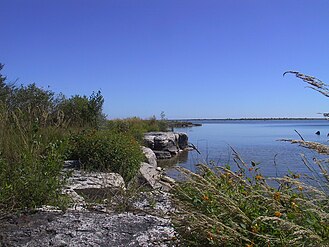
| photo_caption = Outcroppings at Newport State Park approximately {{convert|10|ft|m}} from [[Lake Michigan]]. |
|||
<!-- map --> |
<!-- map --> |
||
| map = USA Wisconsin#USA |
| map = USA Wisconsin#USA |
||
| Line 34: | Line 36: | ||
| designation = |
| designation = |
||
<!-- dates & info --> |
<!-- dates & info --> |
||
| authorized = by the county board on December 11, 1961<ref>[http://pubinfo.co.door.wi.us:8080/jsp/RcWebImageViewer.jsp?doc_id=1e8fc801-90a4-4104-8e86-19a1ea0947dc/wsbd0000/20151119/00000213&pg_seq=5&search_doc=&query1_modifier=AND&query1=resolution%20no%20208&query1_field=CONTENT&query2_modifier=AND&query2_field=DATE_PUBLISHED_MILLIS&query2_min=-252460800000&query2_max=-221011200000 Resolution No. 208] passed by the Door County Board of Supervisors, ''Door County Advocate'', January 16, 1962</ref> |
|||
| authorized = |
|||
| created = |
| created = |
||
| designated = |
| designated = |
||
| Line 51: | Line 53: | ||
}} |
}} |
||
'''Newport State Park''' is a {{convert|2373|acre| |
'''Newport State Park''' is a {{convert|2373|acre|adj=on}} [[List of Wisconsin state parks|Wisconsin state park]] at the tip of [[Door Peninsula]] near [[Europe Lake]]. Protecting {{convert|11|mi|km}} of shoreline on [[Lake Michigan]], Newport is Wisconsin's only [[wilderness]]-designated state park. The park is open year-round<ref>{{Cite web|url=https://dnr.wi.gov/topic/parks/name/newport/|title=Newport State Park - Wisconsin DNR|website=dnr.wi.gov|access-date=2018-07-06}}</ref> and can be accessed via [[WIS 42]]. |
||
== History == |
|||
In 1946, the State Planning Board and the Wisconsin Conservation Department recommended the area as a place to develop a park. In 1958 the National Park Service and the Wisconsin Conservation Department also recommended the area. On September 24, 1964, the park was established as Europe Bay State Park. In August 1970, the name was changed to Newport State Park to reflect a park expansion. In 1970 the day use area and entrance road were constructed. Campsites were completed in the summer of 1973.<ref>[https://embed.widencdn.net/pdf/plus/widnr/xdra4wnyfx/FL_NewportSP_MasterPlan_1975.pdf Newport State Park Guidelines] by William T. Mooman, ''Wisconsin Department of Natural Resources'', August 30, 1973, section on Chronology, page 28</ref> On April 25, 1978 a tract of land between Europe Lake and Europe Bay was added to the park.<ref>[https://embed.widencdn.net/pdf/plus/widnr/roinrwvi3e/FL_NewportSP_Addendum_1979.pdf Addendum to the Master Plan Newport State Park], submitted by D. J. Mackie, ''Wisconsin Department of Natural Resources'', July 23, 1979, section on Background, pages 1 and 6 (pages 3 and 8 of the pdf)</ref> |
|||
In 2017, the [[International Dark-Sky Association]] named Newport a Dark Sky Park.<ref>Lee Bergquist. "[http://www.jsonline.com/story/news/local/wisconsin/2017/06/07/newport-state-park-designated-dark-sky-park/375936001 Newport State Park designated as Wisconsin's first 'dark sky' park/]". ''Milwaukee Journal Sentinel'', June 7, 2017.</ref> |
|||
==Air pollution monitor== |
==Air pollution monitor== |
||
[[File:HYSPLITTrajectoriesforNewportStateParkpage72.jpg|thumb |
{{stack|[[File:HYSPLITTrajectoriesforNewportStateParkpage72.jpg|thumb|2016 [[HYSPLIT]] map]]}} |
||
The only public air pollution monitor in the county is located in Newport State Park.<ref>Photo of the monitoring station on page 128 of {{cite web|url=https://www.epa.gov/sites/production/files/2017-09/documents/wiplan2016.pdf|title=Air Monitoring Network Plan 2016 June 2015|author=WI DNR|website=EPA| |
The only public air pollution monitor in the county is located in Newport State Park.<ref>Photo of the monitoring station on page 128 of {{cite web|url=https://www.epa.gov/sites/production/files/2017-09/documents/wiplan2016.pdf|title=Air Monitoring Network Plan 2016 June 2015|author=WI DNR|website=EPA|access-date=2019-02-06}}</ref> Most air pollution reaching the station comes from outside the county. This map shows how air travels to the monitoring station. Because the station is near the shore, only the red lines (which show the lower air currents) meaningfully depict the path of ozone to the monitor. As shown on the map, these lower air currents carry polluted air from major urban areas. Farther inland, however, the air from higher up mixes more, so all color lines are significant when tracing the path of air pollution further inland, and these higher air currents (shown in green and blue) blow in from cleaner, mostly rural areas.<ref>{{cite web|url=https://www.epa.gov/sites/production/files/2018-05/documents/wi_tsd_final.pdf |
||
|title=Wisconsin: Northern Milwaukee/Ozaukee Shoreline Area, Sheboygan County Area, Manitowoc County Area, Door County Area Final Area Designations for the 2015 Ozone National Ambient Air Quality Standards Technical Support Document (TSD)|author=US EPA|website=Green Book| |
|title=Wisconsin: Northern Milwaukee/Ozaukee Shoreline Area, Sheboygan County Area, Manitowoc County Area, Door County Area Final Area Designations for the 2015 Ozone National Ambient Air Quality Standards Technical Support Document (TSD)|author=US EPA|website=Green Book|access-date=2019-02-07}}</ref> |
||
==Climate== |
|||
{{Further|Climate of Door County, Wisconsin}} |
|||
{{climate chart |
|||
| Europe Bay |
|||
| -9| -4| 66 |
|||
| -10| -8| 60 |
|||
| -4| 0| 62 |
|||
| 0| 3| 112 |
|||
| 3| 9| 86 |
|||
| 10| 13| 77 |
|||
| 16| 18| 96 |
|||
| 16| 19| 73 |
|||
| 14| 17| 109 |
|||
| 7| 10| 119 |
|||
| 5| 6| 110 |
|||
| 1| 4| 66 |
|||
|float=right |
|||
|clear=right |
|||
|source = <ref name = "nasa">{{Cite web |url= https://search.earthdata.nasa.gov/|title= NASA EarthData Search |access-date = 30 January 2016 |publisher= NASA}}</ref> |
|||
}} |
|||
The climate of Newport is humid, microthermal with cool summers and with an even monthly precipitation distribution. The climate of the park is modified considerably by its close proximity to Lake Michigan and Green Bay. This is reflected in the fewer number of days with extremely high or low temperatures than are common for that latitude. Spring and early summer are retarded by the surrounding cool water; summers are mild and pleasant. Relatively warm lake water delays the first freeze in fall, and the winters are cold. The lake influence is also seen in higher average cloudiness and lower percentage of sunshine than is found at stations located further away from the lake.<ref name=EIS/> |
|||
From data compiled in 1974, prevailing winds are from the northwest through the southwest, with the exception of early spring when northeast winds dominate. April and November are the windiest months with averages of 12 miles per hour. Speeds in excess of 60 miles per hour can be expected to occur in seven of ten years. The highest speeds are usually from the west or southwest.<ref name=EIS/> |
|||
As of figures available in 1974, the percentage of possible sunshine has averaged about 40 percent for November and December and 60 percent or more from May through September. The remaining months average between 50 and 60 percent. The yearly average temperature at Sturgeon Bay is 43.8 °F. The average daily maximum for the month of January is 26.7 °F with the average daily minimum for January at 10.4 °F. The average daily maximum for July is 80.1 °F with an average daily minimum of 57.4 °F.<ref name=EIS>[https://babel.hathitrust.org/cgi/pt?id=uiug.30112078786966&view=1up&seq=11&skin=2021 Environmental impact statement for the proposed development and management of Newport State Park, Door County, Wisconsin], by the Wisconsin Bureau of Parks and Recreation, by C. D. Besadny, Director, Bureau of Environmental Impact, September 1974, page 11</ref> |
|||
{{clear}} |
|||
== Gallery == |
|||
{{gallery|mode=packed|align=center|width=165|height=165 |
{{gallery|mode=packed|align=center|width=165|height=165 |
||
|File:Gfp-wisconsin-newport-state-park-park-landscape.jpg|View towards water |
|||
|Image:NewportStateParkSign.jpg|Sign |
|||
|File:View at or near Lynd Point, Newport State Park, August 2019.jpg|View towards land |
|||
|Image:NewportStateParkBeach.jpg|Looking north at the beach |
|||
|File:Crevice in the rock, Lynd Point vicinity, Newport State Park, August 2019.jpg|Crevice in the rock, Lynd Point vicinity |
|||
|File:Fern Trail, Newport State Park, August 2019.jpg|Fern Trail |
|||
|File:Newport_State_Park_in_Door_County.jpg|Looking north at the beach with kayakers |
|||
|Image:NewportStateParkBeachSouth.jpg|Looking south at the beach |
|Image:NewportStateParkBeachSouth.jpg|Looking south at the beach |
||
|File:Newport Trail Wilderness Site 3.jpg|Campsite #3; all campsites require hiking to the site. [[Norbert Blei]] commented "I like the idea of Newport State Park, where you have to hike back in to your campsite. There should be some places that you have to earn, to deserve; it can't all be watching the sunset in Ephraim from Wilson's. That's too easy."<ref>[https://babel.hathitrust.org/cgi/pt?id=umn.31951t002328748&view=1up&seq=183&skin=2021 "It boils down to greed"] by Norbert Blei, in Conversations on Door County by Dave Crehore, ''Wisconsin Natural Resources'', May-June 1986, Volume 10, Number 3, Wisconsin Department of Natural Resources, page 47</ref> |
|||
|Image:NewportStateParkRangerStation.jpg|Ranger station |
|Image:NewportStateParkRangerStation.jpg|Ranger station |
||
}} |
|||
===Plants=== |
|||
{{gallery|mode=packed|align=center|width=165|height=165 |
|||
|File:American Starflower Lysimachia borealis Newport State Park Wisconsin.jpg|American starflower, ''Trientalis borealis'', synonym ''[[Lysimachia borealis]]'', May |
|||
|File:Bluebead Clintonia borealis Newport State Park Door County Wisconsin.jpg|Bluebead, ''[[:w:Clintonia borealis|Clintonia borealis]]'', May |
|||
|File:Viola nephrophylla (4711056912).jpg|Northern Bog Violet, ''[[:w:Viola nephrophylla|Viola nephrophylla]]'', May |
|||
|File:Alpine Cancer Root-1.jpg|American cancer-root, ''[[:w:Conopholis americana|Conopholis americana]]'', June |
|||
|File:Gfp-wisconsin-newport-state-park-little-pine-trees.jpg|Common club-moss, [[Spinulum annotinum]], synonym ''Lycopodium annotinum'', August |
|||
|File:Newport State Park - Duck Bay along the Newport Trail.jpg|Duck Bay along Newport Trail with reed canary grass (''[[Phalaris arundinacea]]'') and orange jewelweed (''[[Impatiens capensis]]'') flowers, September |
|||
}} |
|||
===Aerial views=== |
|||
{{gallery|mode=packed|align=center|width=165|height=165 |
|||
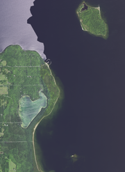
|File:Europe Lake, Europe Bay, Plum Island, Gravel Island, and Newport State Park, town of Liberty Grove, Door County, Wisconsin 2020.png|Northern area of the park and surrounding area |
|||
|File:Newport State Park and Spider Island, town of Liberty Grove, Door County, Wisconsin 2020.png|Southeastern area of the park and surrounding area |
|||
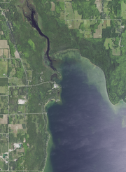
|File:Aerial view of the Mink River and Rowleys Bay, Door County, Wisconsin 2020.png|Southwestern area of the park and surrounding area |
|||
}} |
}} |
||
==References== |
==References== |
||
{{reflist}} |
{{reflist|1}} |
||
==External links== |
==External links== |
||
{{commons category}} |
|||
*[https://friendsofnewport.org Newport Wilderness Society] (Friends Group of Newport State Park) |
|||
*[https://gispub.epa.gov/airnow/?xmin=-9799593.923895366&ymin=5536056.626209926&xmax=-9650878.041663727&ymax=5730100.5739332875&clayer=none&mlayer=ozonepm# Interactive Map of Air Quality, Northeast Wisconsin], ''Environmental Protection Agency'' (Has real-time ozone readings from the monitor at Newport State Park.) |
|||
*[http://dnr.wi.gov/topic/parks/name/newport/ Newport State Park website] |
*[http://dnr.wi.gov/topic/parks/name/newport/ Newport State Park website] |
||
*[https://web.archive.org/web/20210624211438/https://dnr.wi.gov/files/PDF/pubs/pr/PR2185.pdf Park map] (pdf, ''Wisconsin DNR'', archived June 24, 2021) |
|||
*[https://web.archive.org/web/20210624202724/https://dnr.wi.gov/topic/parks/name/newport/pdfs/newportwintermap.pdf Winter Use Map] (pdf, ''Wisconsin DNR'', archived June 24, 2021) |
|||
*[https://web.archive.org/web/20210624211438/https://dnr.wi.gov/files/PDF/pubs/pr/PR2185.pdf Hunting and Trapping Map] (pdf, ''Wisconsin DNR'', archived June 24, 2021) |
|||
*[https://huntfishcampwisconsin.com/newport.pdf Park map] (pdf, huntfishcampwisconsin.com) |
|||
*[https://trailgenius.com/trail-genius-map/newport-state-park Interactive trail map] (Trail Genius) |
|||
{{Protected areas of Wisconsin}} |
{{Protected areas of Wisconsin}} |
||
{{authority control}} |
|||
[[Category:Protected areas of Door County, Wisconsin]] |
[[Category:Protected areas of Door County, Wisconsin]] |
||
| Line 76: | Line 146: | ||
[[Category:Protected areas established in 1964]] |
[[Category:Protected areas established in 1964]] |
||
[[Category:1964 establishments in Wisconsin]] |
[[Category:1964 establishments in Wisconsin]] |
||
[[Category:International Dark Sky Reserves]] |
|||
{{DoorCountyWI-geo-stub}} |
|||
{{Wisconsin-protected-area-stub}} |
|||
Latest revision as of 01:22, 3 August 2023
| Newport State Park | |
|---|---|
IUCN category V (protected landscape/seascape) | |
 | |
  | |
| Location | Door, Wisconsin, United States |
| Coordinates | 45°14′6″N 86°59′39″W / 45.23500°N 86.99417°W |
| Area | 2,373 acres (9.60 km2) |
| Authorized | by the county board on December 11, 1961[1] |
| Governing body | Wisconsin Department of Natural Resources |
Newport State Park is a 2,373-acre (960 ha) Wisconsin state park at the tip of Door Peninsula near Europe Lake. Protecting 11 miles (18 km) of shoreline on Lake Michigan, Newport is Wisconsin's only wilderness-designated state park. The park is open year-round[2] and can be accessed via WIS 42.
History[edit]
In 1946, the State Planning Board and the Wisconsin Conservation Department recommended the area as a place to develop a park. In 1958 the National Park Service and the Wisconsin Conservation Department also recommended the area. On September 24, 1964, the park was established as Europe Bay State Park. In August 1970, the name was changed to Newport State Park to reflect a park expansion. In 1970 the day use area and entrance road were constructed. Campsites were completed in the summer of 1973.[3] On April 25, 1978 a tract of land between Europe Lake and Europe Bay was added to the park.[4]
In 2017, the International Dark-Sky Association named Newport a Dark Sky Park.[5]
Air pollution monitor[edit]

The only public air pollution monitor in the county is located in Newport State Park.[6] Most air pollution reaching the station comes from outside the county. This map shows how air travels to the monitoring station. Because the station is near the shore, only the red lines (which show the lower air currents) meaningfully depict the path of ozone to the monitor. As shown on the map, these lower air currents carry polluted air from major urban areas. Farther inland, however, the air from higher up mixes more, so all color lines are significant when tracing the path of air pollution further inland, and these higher air currents (shown in green and blue) blow in from cleaner, mostly rural areas.[7]
Climate[edit]
| Europe Bay | ||||||||||||||||||||||||||||||||||||||||||||||||||||||||||||
|---|---|---|---|---|---|---|---|---|---|---|---|---|---|---|---|---|---|---|---|---|---|---|---|---|---|---|---|---|---|---|---|---|---|---|---|---|---|---|---|---|---|---|---|---|---|---|---|---|---|---|---|---|---|---|---|---|---|---|---|---|
| Climate chart (explanation) | ||||||||||||||||||||||||||||||||||||||||||||||||||||||||||||
| ||||||||||||||||||||||||||||||||||||||||||||||||||||||||||||
| ||||||||||||||||||||||||||||||||||||||||||||||||||||||||||||
The climate of Newport is humid, microthermal with cool summers and with an even monthly precipitation distribution. The climate of the park is modified considerably by its close proximity to Lake Michigan and Green Bay. This is reflected in the fewer number of days with extremely high or low temperatures than are common for that latitude. Spring and early summer are retarded by the surrounding cool water; summers are mild and pleasant. Relatively warm lake water delays the first freeze in fall, and the winters are cold. The lake influence is also seen in higher average cloudiness and lower percentage of sunshine than is found at stations located further away from the lake.[9]
From data compiled in 1974, prevailing winds are from the northwest through the southwest, with the exception of early spring when northeast winds dominate. April and November are the windiest months with averages of 12 miles per hour. Speeds in excess of 60 miles per hour can be expected to occur in seven of ten years. The highest speeds are usually from the west or southwest.[9]
As of figures available in 1974, the percentage of possible sunshine has averaged about 40 percent for November and December and 60 percent or more from May through September. The remaining months average between 50 and 60 percent. The yearly average temperature at Sturgeon Bay is 43.8 °F. The average daily maximum for the month of January is 26.7 °F with the average daily minimum for January at 10.4 °F. The average daily maximum for July is 80.1 °F with an average daily minimum of 57.4 °F.[9]
Gallery[edit]
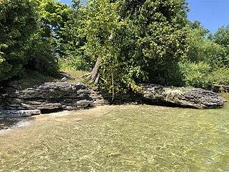
-
 View towards water
 -
 View towards land
 -
 Crevice in the rock, Lynd Point vicinity
 -
 Fern Trail
 -
 Looking north at the beach with kayakers
 -
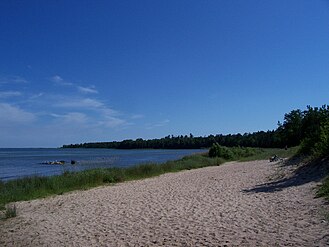 Looking south at the beach
 -
![Campsite #3; all campsites require hiking to the site. Norbert Blei commented "I like the idea of Newport State Park, where you have to hike back in to your campsite. There should be some places that you have to earn, to deserve; it can't all be watching the sunset in Ephraim from Wilson's. That's too easy."[10]](//upload.wikimedia.org/wikipedia/commons/thumb/6/60/Newport_Trail_Wilderness_Site_3.jpg/329px-Newport_Trail_Wilderness_Site_3.jpg) Campsite #3; all campsites require hiking to the site. Norbert Blei commented "I like the idea of Newport State Park, where you have to hike back in to your campsite. There should be some places that you have to earn, to deserve; it can't all be watching the sunset in Ephraim from Wilson's. That's too easy."[10]
Campsite #3; all campsites require hiking to the site. Norbert Blei commented "I like the idea of Newport State Park, where you have to hike back in to your campsite. There should be some places that you have to earn, to deserve; it can't all be watching the sunset in Ephraim from Wilson's. That's too easy."[10] -
 Ranger station


![Campsite #3; all campsites require hiking to the site. Norbert Blei commented "I like the idea of Newport State Park, where you have to hike back in to your campsite. There should be some places that you have to earn, to deserve; it can't all be watching the sunset in Ephraim from Wilson's. That's too easy."[10]](/wiki/File:Newport_Trail_Wilderness_Site_3.jpg)

Plants[edit]
-
 American starflower, Trientalis borealis, synonym Lysimachia borealis, May
 -
 Bluebead, Clintonia borealis, May
 -
 Northern Bog Violet, Viola nephrophylla, May
 -
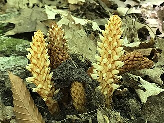 American cancer-root, Conopholis americana, June
 -
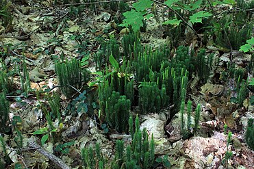 Common club-moss, Spinulum annotinum, synonym Lycopodium annotinum, August
 -
 Duck Bay along Newport Trail with reed canary grass (Phalaris arundinacea) and orange jewelweed (Impatiens capensis) flowers, September


.jpg)


Aerial views[edit]
-
 Northern area of the park and surrounding area
 -
 Southeastern area of the park and surrounding area
 -
 Southwestern area of the park and surrounding area


References[edit]
- ^ Resolution No. 208 passed by the Door County Board of Supervisors, Door County Advocate, January 16, 1962
- ^ "Newport State Park - Wisconsin DNR". dnr.wi.gov. Retrieved July 6, 2018.
- ^ Newport State Park Guidelines by William T. Mooman, Wisconsin Department of Natural Resources, August 30, 1973, section on Chronology, page 28
- ^ Addendum to the Master Plan Newport State Park, submitted by D. J. Mackie, Wisconsin Department of Natural Resources, July 23, 1979, section on Background, pages 1 and 6 (pages 3 and 8 of the pdf)
- ^ Lee Bergquist. "Newport State Park designated as Wisconsin's first 'dark sky' park/". Milwaukee Journal Sentinel, June 7, 2017.
- ^ Photo of the monitoring station on page 128 of WI DNR. "Air Monitoring Network Plan 2016 June 2015" (PDF). EPA. Retrieved February 6, 2019.
- ^ US EPA. "Wisconsin: Northern Milwaukee/Ozaukee Shoreline Area, Sheboygan County Area, Manitowoc County Area, Door County Area Final Area Designations for the 2015 Ozone National Ambient Air Quality Standards Technical Support Document (TSD)" (PDF). Green Book. Retrieved February 7, 2019.
- ^ "NASA EarthData Search". NASA. Retrieved January 30, 2016.
- ^ a b c Environmental impact statement for the proposed development and management of Newport State Park, Door County, Wisconsin, by the Wisconsin Bureau of Parks and Recreation, by C. D. Besadny, Director, Bureau of Environmental Impact, September 1974, page 11
- ^ "It boils down to greed" by Norbert Blei, in Conversations on Door County by Dave Crehore, Wisconsin Natural Resources, May-June 1986, Volume 10, Number 3, Wisconsin Department of Natural Resources, page 47
External links[edit]
- Newport Wilderness Society (Friends Group of Newport State Park)
- Interactive Map of Air Quality, Northeast Wisconsin, Environmental Protection Agency (Has real-time ozone readings from the monitor at Newport State Park.)
- Newport State Park website
- Park map (pdf, Wisconsin DNR, archived June 24, 2021)
- Winter Use Map (pdf, Wisconsin DNR, archived June 24, 2021)
- Hunting and Trapping Map (pdf, Wisconsin DNR, archived June 24, 2021)
- Park map (pdf, huntfishcampwisconsin.com)
- Interactive trail map (Trail Genius)
| International | |
|---|---|
| National | |