
Route 1 (Iceland): Difference between revisions
Fix cite date errors |
m v2.04b - Bot T20 CW#61 - Fix errors for CW project (Reference before punctuation) |
||
| Line 24: | Line 24: | ||
==Characteristics== |
==Characteristics== |
||
The Ring Road is [[Paved (road)|paved]] for all of its length and is mostly two lanes wide: one lane going in each direction<ref>{{cite web|title=Vegasjá|url=http://vegasja.vegagerdin.is/eng/|access-date=2020-01-24}}</ref> |
The Ring Road is [[Paved (road)|paved]] for all of its length and is mostly two lanes wide: one lane going in each direction.<ref>{{cite web|title=Vegasjá|url=http://vegasja.vegagerdin.is/eng/|access-date=2020-01-24}}</ref> The Icelandic Road Administration, [[Vegagerðin]], oversees the maintenance and operation of the Ring Road. The road is generally of good quality, recent road improvement projects have improved safety considerably. However the road still has hazards, going over many higher-altitude [[Mountain pass|mountain passes]] in all parts of the country, which can have steep [[Road gradient|gradients]] and sharp curves, as well as [[Blind corner|blind curves and summits]] and single-lane bridges, especially in the more rural east of the country. Driving in winter one must take special precautions and pre-check driving conditions with the [http://www.road.is Icelandic Road Administration] to ensure the road is passable. |
||
The [[Speed limits in Iceland|speed limit]] is {{convert|90|km/h|mph}} on open sections; {{convert|70|km/h|mph}} in tunnels and {{convert|50|km/h|mph}} through urban areas. A few speed cameras operate on roads just outside of Reykjavík and in all tunnels. |
The [[Speed limits in Iceland|speed limit]] is {{convert|90|km/h|mph}} on open sections; {{convert|70|km/h|mph}} in tunnels and {{convert|50|km/h|mph}} through urban areas. A few speed cameras operate on roads just outside of Reykjavík and in all tunnels. |
||
| Line 36: | Line 36: | ||
=== Driving in winter === |
=== Driving in winter === |
||
Route 1 has the highest priority for [[snow removal]] from the [[Icelandic Road Administration]] and is serviced 7 days a week during the winter<ref>{{Cite web|title=Vinnureglur þjónustudeildar|url=http://www.vegagerdin.is/upplysingar-og-utgafa/leidbeiningar-og-stadlar/vetrarthjonusta/vinnureglur/5d56cbb8d3175dea0025769b003b945a?OpenDocument|access-date=2021-10-04|website=Vegagerðin|language=is}}</ref> |
Route 1 has the highest priority for [[snow removal]] from the [[Icelandic Road Administration]] and is serviced 7 days a week during the winter,<ref>{{Cite web|title=Vinnureglur þjónustudeildar|url=http://www.vegagerdin.is/upplysingar-og-utgafa/leidbeiningar-og-stadlar/vetrarthjonusta/vinnureglur/5d56cbb8d3175dea0025769b003b945a?OpenDocument|access-date=2021-10-04|website=Vegagerðin|language=is}}</ref> with teams keeping the road open as weather allows Conditions are monitored 24/7 and relayed to the public through their website and telephone helpline. During extreme weather it may take hours until the weather calms down to open the road, or for maintanance teams to clear the road of snow after major snowfalls. |
||
A few major mountain passes prone to closure in heavily trafficed parts of the ring road: |
A few major mountain passes prone to closure in heavily trafficed parts of the ring road: |
||
| Line 46: | Line 46: | ||
* Biskupsháls, between Akureyri and Egilsstaðir |
* Biskupsháls, between Akureyri and Egilsstaðir |
||
Winter closures used to be more common in the past. In recent years, new tunnels such as the 7.4km long [[Vaðlaheiðargöng]] near [[Akureyri]] in the north, have reduced the need to close the road due to snow. Prior to rerouting, the route between [[Breiðdalsvík]] and [[Egilsstaðir]] (over the ''Breiðdalsheiði'' plateau) in the east was often closed in winter.<ref>{{cite web|title=Mokstursdagar|url=http://www.vegagerdin.is/upplysingar-og-utgafa/leidbeiningar-og-stadlar/vetrarthjonusta/mokstursdagar/|publisher=Icelandic Road Administration|access-date=12 February 2014|language=is}}</ref> Route 1 was rerouted in November 2017<ref name="change2017">{{cite web|author=Geir Finnsson|date=9 November 2017|title=Changes To Ring Road This Weekend|url=http://icelandreview.com/news/2017/11/09/changes-ring-road-weekend|access-date=14 November 2017|work=Iceland Review}}</ref> |
Winter closures used to be more common in the past. In recent years, new tunnels such as the 7.4km long [[Vaðlaheiðargöng]] near [[Akureyri]] in the north, have reduced the need to close the road due to snow. Prior to rerouting, the route between [[Breiðdalsvík]] and [[Egilsstaðir]] (over the ''Breiðdalsheiði'' plateau) in the east was often closed in winter.<ref>{{cite web|title=Mokstursdagar|url=http://www.vegagerdin.is/upplysingar-og-utgafa/leidbeiningar-og-stadlar/vetrarthjonusta/mokstursdagar/|publisher=Icelandic Road Administration|access-date=12 February 2014|language=is}}</ref> Route 1 was rerouted in November 2017,<ref name="change2017">{{cite web|author=Geir Finnsson|date=9 November 2017|title=Changes To Ring Road This Weekend|url=http://icelandreview.com/news/2017/11/09/changes-ring-road-weekend|access-date=14 November 2017|work=Iceland Review}}</ref> now using the somewhat sinuous coastal route via [[Reyðarfjörður]], using (now former) Routes [[Route 96 (Iceland)|96]] and [[Route 92 (Iceland)|92]] to travel between the towns. |
||
=== Natural hazards === |
=== Natural hazards === |
||
| Line 56: | Line 56: | ||
Route 1 is popular with [[tourism|tourists]] since it covers most of the country and many sights of interest are located near to the route. It has long been a popular tour with Icelandic families going on summer vacation, but in recent years the route is becoming more popular with foreign tourists who either rent a car or bring their own on the ferry to [[Seyðisfjörður]]. |
Route 1 is popular with [[tourism|tourists]] since it covers most of the country and many sights of interest are located near to the route. It has long been a popular tour with Icelandic families going on summer vacation, but in recent years the route is becoming more popular with foreign tourists who either rent a car or bring their own on the ferry to [[Seyðisfjörður]]. |
||
Traffic levels on the road vary considerably between locations: in and near [[Reykjavík]] around 20,000-50,000 vehicles use the road daily<ref>{{Cite web|last=Vegagerðin (The Icelandic Road Administration)|date=1 January 2020|title=Daily traffic map of Iceland - 2020|url=https://umferd.vegagerdin.is/|url-status=live|access-date=4 October 2021}}</ref> |
Traffic levels on the road vary considerably between locations: in and near [[Reykjavík]] around 20,000-50,000 vehicles use the road daily,<ref>{{Cite web|last=Vegagerðin (The Icelandic Road Administration)|date=1 January 2020|title=Daily traffic map of Iceland - 2020|url=https://umferd.vegagerdin.is/|url-status=live|access-date=4 October 2021}}</ref> rural sections serving routes between Reykjavik and Akureyri in the west and Reykjavík and [[Vík í Mýrdal|Vík]] in the south see traffic volumes of around 2,000 to 5,000 vehicles per day. The stretches farthest away from larger towns, mostly in the sparsley inhabited east of the country see an average around 500 vehicles per day. |
||
Traffic on the ring road is also subject to considerable variation between the winter and summer, with the traffic in summer often being double or more during the summer. This is due to a lower flow of tourist and agricultural traffic, as well as the roads being less passable or even closed during the winter. Traffic can become considerably heavy on weekends during the summer, when locals flock to travel around the country for holidays, camping and summer house visits across the country. |
Traffic on the ring road is also subject to considerable variation between the winter and summer, with the traffic in summer often being double or more during the summer. This is due to a lower flow of tourist and agricultural traffic, as well as the roads being less passable or even closed during the winter. Traffic can become considerably heavy on weekends during the summer, when locals flock to travel around the country for holidays, camping and summer house visits across the country. |
||
Heavy summer traffic is especially a problem during the summer at the town of [[Selfoss (town)|Selfoss]], where a single two lane bridge, Ölfusárbrú, is routed through the town carries practially all of the traffic in the south of the country, a significant bottleneck<ref>{{Cite web|date=2021-07-10|title=Umferð gengur hægt fyrir sig við Selfoss|url=https://www.ruv.is/frett/2021/07/10/umferd-gengur-haegt-fyrir-sig-vid-selfoss|access-date=2021-10-03|website=RÚV|language=is}}</ref> |
Heavy summer traffic is especially a problem during the summer at the town of [[Selfoss (town)|Selfoss]], where a single two lane bridge, Ölfusárbrú, is routed through the town carries practially all of the traffic in the south of the country, a significant bottleneck.<ref>{{Cite web|date=2021-07-10|title=Umferð gengur hægt fyrir sig við Selfoss|url=https://www.ruv.is/frett/2021/07/10/umferd-gengur-haegt-fyrir-sig-vid-selfoss|access-date=2021-10-03|website=RÚV|language=is}}</ref> This is planned to be replaced by a new bypass road and new bridge over the [[Ölfusá|Ölfus]] river, with current plans seeing it complete by 2023-2024<ref>{{Cite web|last=Hreiðarsson|first=Magnús Hlynur|title=Sigurður Ingi lofar nýrri Ölfusárbrú í lok árs 2023 eða 2024 - Vísir|url=https://www.visir.is/g/20212118939d|access-date=2021-10-03|website=visir.is|language=is}}</ref> |
||
== Sections == |
== Sections == |
||
Revision as of 09:59, 16 October 2021
 | |
|---|---|
| Þjóðvegur 1 | |
 | |
| Route information | |
| Length | 1,322 km[1] (821 mi) |
| Location | |
| Country | Iceland |
| Highway system | |
Route 1 or the Ring Road (Icelandic: Þjóðvegur 1 or Hringvegur [ˈr̥iŋkˌvɛːɣʏr̥]) is a national road in Iceland that circles the entire country. As a major trunk route, it is considered to be the most important piece of transport infrastructure in Iceland as it connects the majority of towns together in the most densley populated areas of the country. Economically, it carries a large proportion of goods traffic as well as tourist traffic. The total length of the road is 1,322 kilometres (821 mi).
The road was completed in 1974, coinciding with the 1,100th anniversary of the country's settlement[2] when the longest bridge in Iceland,[3] crossing the Skeiðará river in the southeast, was opened. Previously, vehicles intending to travel between southern settlements, e.g. Vík to Höfn, had to travel north of the country through Akureyri, making the opening a major transport improvement to the country.
Many popular tourist attractions in Iceland, such as the Seljalandsfoss and Skógafoss waterfalls, Dyrhólaey cliffs, Jökulsárlón glacier lagoon, as well as Mývatn lake, Dettifoss and Goðafoss waterfalls in the north are easily accessible from the Ring Road. The road passes through almost all areas of the country (everwhere apart from the Westfjords), making it a popular itinerary to take for tourists and vacationing locals alike in Iceland.
Characteristics
The Ring Road is paved for all of its length and is mostly two lanes wide: one lane going in each direction.[4] The Icelandic Road Administration, Vegagerðin, oversees the maintenance and operation of the Ring Road. The road is generally of good quality, recent road improvement projects have improved safety considerably. However the road still has hazards, going over many higher-altitude mountain passes in all parts of the country, which can have steep gradients and sharp curves, as well as blind curves and summits and single-lane bridges, especially in the more rural east of the country. Driving in winter one must take special precautions and pre-check driving conditions with the Icelandic Road Administration to ensure the road is passable.
The speed limit is 90 kilometres per hour (56 mph) on open sections; 70 kilometres per hour (43 mph) in tunnels and 50 kilometres per hour (31 mph) through urban areas. A few speed cameras operate on roads just outside of Reykjavík and in all tunnels.
In recent years, due to increased traffic and demands for higher road safety, many large improvements have been made in both capacity and safety of the ring road.[5] In the southwestern corner of the country, near Reykjavík, between the larger towns of Borganes and Selfoss, the road is now mostly a 2+1 lane partly-controlled access highway, usually divided by a barrier and is has three or four lanes of traffic. At current traffic levels, 2+1 lane roads provide similar safety and traffic requirements to a regular 2 lane expressway, and can be upgraded when traffic neccitates it. The 7.4km long Vaðlaheiðargöng tunnel near Akureyri in the north of the country shortened the route by 16km and improved winter safety, bypassing a mountain road.
Single-lane bridges
In more rural parts of the country, mostly in the glacial plains of south and the Eastfjords, 32 single-lane bridges exist on the Ring Road. Dating back to the original construction of the road in the 1970s, they are sometimes constructed of wood or steel. Vehicles who approach the bridge first have the right of way. These are often narrow and long, making passing difficult, especially when there is high traffic.
Non-locals, unaware of the rules of single-lane bridges, have ended in head-on and serious collisions using these bridges. Considered a major safety issue, the Icelandic Road Administration aims to rebuild/upgrade all bridges on the ring road to modern 2 lane standards. Single lane bridges were reduced from around 60 in 2010, to 32 in 2020.[6] In the next 5 years, a further 14 one-lane bridges are to be rebuilt, mostly along the south coast. [7]
Driving in winter
Route 1 has the highest priority for snow removal from the Icelandic Road Administration and is serviced 7 days a week during the winter,[8] with teams keeping the road open as weather allows Conditions are monitored 24/7 and relayed to the public through their website and telephone helpline. During extreme weather it may take hours until the weather calms down to open the road, or for maintanance teams to clear the road of snow after major snowfalls.
A few major mountain passes prone to closure in heavily trafficed parts of the ring road:
- Hellisheiði, between Reykjavík and Hveragerði
- Holtavörðuheði, between Borganes and Staðarskáli (on the Reykjavík to Akureyri route)
- Vatnsskarð, between Blönduós and Varmahlíð (on the Reykjavík to Akureyri route)
- Öxnadalsheiði, between Varmahlíð and Akureyri (on the Reykjavík to Akureyri route)
- Biskupsháls, between Akureyri and Egilsstaðir
Winter closures used to be more common in the past. In recent years, new tunnels such as the 7.4km long Vaðlaheiðargöng near Akureyri in the north, have reduced the need to close the road due to snow. Prior to rerouting, the route between Breiðdalsvík and Egilsstaðir (over the Breiðdalsheiði plateau) in the east was often closed in winter.[9] Route 1 was rerouted in November 2017,[10] now using the somewhat sinuous coastal route via Reyðarfjörður, using (now former) Routes 96 and 92 to travel between the towns.
Natural hazards
Route 1 crosses a few glacial plains, such as Skeiðarársandur, which made the original road construction difficult in the 1970s. In addition, the Skeiðarársandur plain is subject to frequent glacial floods during or after eruptions on the nearby Grímsvötn volcano. Bridges and other stretches of road over the plains have had to be rebuilt as a result, notably during the eruption of Eyjafjallajökull in 2010, when the ring road was severed for several days in the south. These are not considered to a be a risk to everyday travellers as the roads are closed well in advance of a warning of a volcanic eruption.
Traffic
Since it's completion, the ring road has seen constant growth in traffic, and has seen an even quicker growth during the recent rise in number of tourists arriving in Iceland. Average traffic recorded along the ring road rose from 57,000 vehicles per day in 2005 to over 90,000 vehicles per day in 2019.[11]
Route 1 is popular with tourists since it covers most of the country and many sights of interest are located near to the route. It has long been a popular tour with Icelandic families going on summer vacation, but in recent years the route is becoming more popular with foreign tourists who either rent a car or bring their own on the ferry to Seyðisfjörður.
Traffic levels on the road vary considerably between locations: in and near Reykjavík around 20,000-50,000 vehicles use the road daily,[12] rural sections serving routes between Reykjavik and Akureyri in the west and Reykjavík and Vík in the south see traffic volumes of around 2,000 to 5,000 vehicles per day. The stretches farthest away from larger towns, mostly in the sparsley inhabited east of the country see an average around 500 vehicles per day.
Traffic on the ring road is also subject to considerable variation between the winter and summer, with the traffic in summer often being double or more during the summer. This is due to a lower flow of tourist and agricultural traffic, as well as the roads being less passable or even closed during the winter. Traffic can become considerably heavy on weekends during the summer, when locals flock to travel around the country for holidays, camping and summer house visits across the country.
Heavy summer traffic is especially a problem during the summer at the town of Selfoss, where a single two lane bridge, Ölfusárbrú, is routed through the town carries practially all of the traffic in the south of the country, a significant bottleneck.[13] This is planned to be replaced by a new bypass road and new bridge over the Ölfus river, with current plans seeing it complete by 2023-2024[14]
Sections
The route goes by many names depending on its location. The following table shows road names (excluding tunnels) in a clockwise direction from Reykjavík.


| Name | Location |
|---|---|
| Vesturlandsvegur | Eastern Reykjavík to Borgarnes |
| Borgarbraut | Borgarnes |
| Hringvegur | Borgarnes to northern Akureyri |
| Hörgárbraut | Akureyri |
| Glerárgata | Akureyri |
| Drottningarbraut (partial) | Akureyri |
| Hringvegur | Southern Akureyri to the turning for Höfn |
| Suðurlandsvegur | Höfn to Hella |
| Suðurlandsbraut | From Hella to Selfoss |
| Austurvegur | Selfoss |
| Suðurlandsvegur | From Selfoss to eastern Reykjavík |
Tunnels on Route 1
List of cities and towns on Route 1
Travelling clockwise (initially northward) from Reykjavík, the following communities and settlements are located on Route 1.
- Reykjavík
- Mosfellsbær
- Borgarnes
- Bifröst
- Blönduós
- Varmahlíð
- Akureyri
- Reykjahlíð
- Egilsstaðir
- Reyðarfjörður
- Eskifjörður
- Fáskrúðsfjörður
- Stöðvarfjörður
- Breiðdalsvík
- Djúpivogur
- Höfn
- Kirkjubæjarklaustur
- Vík í Mýrdal (Vík)
- Skógar
- Hvolsvöllur
- Hella
- Selfoss
- Hveragerði
In popular culture
During the 2016 summer solstice, the Icelandic band Sigur Rós filmed and broadcast a live Slow TV event tour of Iceland driving along the entire route. The event was broadcast live in 360-degree video with a soundtrack of constantly evolving music based around elements of their track Óveður.[15]
Gallery
-
 Road sign
 -
 A typical stretch of Route 1, in Borgarfjörður
 -

-
 Road conditions are monitored in real time by a system of weather stations and webcams, such as this station at Vatnsskarð pass in north Iceland.
 -
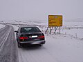
 An icy stretch of Route 1 between Vík í Mýrdal and Höfn
 -
 Distance sign (southbound) near Egilsstaðir
 -
 A now disused single-lane bridge in south Iceland.
 -
 Previously unpaved stretch between Egilsstaðir and Höfn


References
- ^ "Vegalengdir (Distances between places)" (in Icelandic). Icelandic Road Administration. Retrieved 12 February 2014.
- ^ "Iceland: Milestones in Icelandic History". Iceland.vefur.is. Retrieved 2010-04-17.
- ^ The Road System - 2012. Icelandic Road Administration, ICERA.
- ^ "Vegasjá". Retrieved 2020-01-24.
- ^ "Fimm milljarðar í breikkun Suðurlandsvegar til 2023". RÚV (in Icelandic). 2020-04-08. Retrieved 2021-10-04.
- ^ "Alls eru 32 einbreiðar brýr eftir á Hringvegi 1". www.bbl.is (in Icelandic). Retrieved 2021-10-04.
- ^ "Einbreiðum brúm á Hringveginum fækkað úr 36 í 22 á næstu fimm árum". www.stjornarradid.is (in Icelandic). Retrieved 2021-10-04.
- ^ "Vinnureglur þjónustudeildar". Vegagerðin (in Icelandic). Retrieved 2021-10-04.
- ^ "Mokstursdagar" (in Icelandic). Icelandic Road Administration. Retrieved 12 February 2014.
- ^ Geir Finnsson (9 November 2017). "Changes To Ring Road This Weekend". Iceland Review. Retrieved 14 November 2017.
- ^ "Umferðin eykst á Hringvegi". Vegagerðin (in Icelandic). Retrieved 2021-10-03.
- ^ Vegagerðin (The Icelandic Road Administration) (1 January 2020). "Daily traffic map of Iceland - 2020". Retrieved 4 October 2021.
{{cite web}}: CS1 maint: url-status (link) - ^ "Umferð gengur hægt fyrir sig við Selfoss". RÚV (in Icelandic). 2021-07-10. Retrieved 2021-10-03.
- ^ Hreiðarsson, Magnús Hlynur. "Sigurður Ingi lofar nýrri Ölfusárbrú í lok árs 2023 eða 2024 - Vísir". visir.is (in Icelandic). Retrieved 2021-10-03.
- ^ "sigur rós - route one". Sigur Rós official website. Retrieved 21 September 2016.