Eyelet (Nethe)
|
Eyelet ( eyelet ) |
||
|
Eyelet with Mühlenbach in Gehrden |
||
| Data | ||
| Water code | EN : 4524 | |
| location | North Rhine-Westphalia , Germany | |
| River system | Weser | |
| Drain over | Nethe → Weser → North Sea | |
| source | North of Neuenheerse 51 ° 41 ′ 9 ″ N , 9 ° 0 ′ 26 ″ E |
|
| Source height | 302 m above sea level NN | |
| muzzle | At Siddessen in the Nethe coordinates: 51 ° 39 ′ 45 ″ N , 9 ° 9 ′ 13 ″ E 51 ° 39 ′ 45 ″ N , 9 ° 9 ′ 13 ″ E |
|
| Mouth height | approx. 149 m above sea level NN | |
| Height difference | approx. 153 m | |
| Bottom slope | approx. 11 ‰ | |
| length | 13.4 km | |
| Catchment area | 40.648 km² | |
|
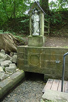
The St. Antonius source is the most famous source of the Öse and is sometimes referred to simply as the Öquelle. |
||
The Öse , also Oese , is a 13.4 km long tributary of the Nethe in the district of Höxter , North Rhine-Westphalia , Germany .
geography
The Öse rises about 1 km northeast of Neuenheerse in a valley cut in the eastern Egge Mountains at an altitude of 302 m above sea level. NN . First flowing to the southeast, the brook passes Dringenberg , then turns its course in an easterly direction, flows through Gehrden and Siddessen and flows out on the eastern edge of the village at 149 m above sea level. NN on the left in the Nethe .
On its 13.4 km long path, the Öse overcomes an altitude difference of 153 m. This corresponds to an average bed slope of 11.4 ‰. The Öse drains a 40.648 km² catchment area via Nethe and Weser to the North Sea .
Tributaries
The most important tributary of the Öse is the 5.1 km long Tiefentalgraben . With its 9.036 km² catchment area, it has a 22% share of that of the Öse. Other longer tributaries are the 3.7 km long Bittertalbach and the 2.8 km long Breitekampbach .
Watershed
The catchment area of the Öse extends as far as the Mittelberg on the main ridge of the Egge Mountains. A section of the Rhine-Weser watershed runs over this . Rivers from the west of the watershed flow to the Rhine , those from the east to the Weser.
Individual evidence
- ↑ a b Topographic map 1: 25000
- ↑ a b Topographical Information Management, Cologne District Government, Department GEObasis NRW
- ↑ cf. various DGK sheets

