Živný potok
|
Živný potok Prachatický potok, Bělečský potok, Rohnbach, Bieltschbach |
||
|
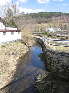
The Živný potok in Prachatice |
||
| Data | ||
| Water code | CZ : 1-08-03-030 | |
| location | Czech Republic | |
| River system | Elbe | |
| Drain over | Blanice → Otava → Vltava → Elbe → North Sea | |
| source | west of Chroboly in the Bohemian Forest foothills 48 ° 57 ′ 29 ″ N , 14 ° 3 ′ 13 ″ E |
|
| Source height | 755 m nm | |
| muzzle | between Těšovice and Běleč in the Blanice coordinates: 49 ° 3 ′ 15 ″ N , 14 ° 1 ′ 45 ″ E 49 ° 3 ′ 15 ″ N , 14 ° 1 ′ 45 ″ E |
|
| Mouth height | 465 m nm | |
| Height difference | 290 m | |
| Bottom slope | 25 ‰ | |
| length | 11.5 km | |
| Catchment area | 33 km² | |
| Drain |
MQ |
290 l / s |
The Živný potok , also Prachatický potok or Bělečský potok (German Rohnbach or Bieltschbach ) is a right tributary of the Blanice in the Czech Republic .
course
The Živný potok rises west of Chroboly and north of Podlesí in the Prachatická hornatina ( Prachatitz Uplands ) belonging to the Šumavské podhůří ( Bohemian Forest Foreland ). Its source is located at the eastern foot of Rohanovský vrch (1010 m) at Chroboly train station. The stream initially flows north past Lučenice, Rohanov and Leptač between the Na Skalce (1025 m) and Lučenický vrch (867 m) mountain; at the Rohanov stop it feeds the Leptačský rybník pond. At the eastern foot of the Libín (1093 m) and its secondary peak Na Vyhlídce (828 m) it forms a deep valley and takes a north-westerly direction. Passing Jelemek, Velišův Mlýn, Lázně svaté Markéty , Kandlův Mlýn and Irův Dvůr, the stream reaches Prachatice , where it turns north again between the Lower Suburb ( Dolní Předměstí ) and the hospital. Its lower course leads past Slepý Mlýn, the quarry Kobylí hora, Staré Prachatice, Ostrov, Městská Lhotka, Bělečská Lhota, Vojtášek, Bělečský Mlýn, the Husinec railway station and Běleč; on this section it flows around the Výrovčice (708 m) east. After 11.4 kilometers, the Živný potok flows into the Blanice between Těšovice and Běleč .
The Číčenice – Haidmühle railway line runs through the Živný potok valley along its entire course . On the upper reaches the state road II / 143 between Chroboly and Prachatice, on the lower reaches the II / 141 between Prachatice and Těšovice the course of the brook.
history
The water power of the brook has been used to operate mills since the Middle Ages, especially near Prachatice. The Rohnmühle ( Leptáčský mlýn ) and the Wallischmühle ( Velišův mlýn ) were located in the mountains . In Prachatice, the Bernkopfmühle ( Bernkopfův mlýn ), the Kandelmühle ( Kandlův mlýn ), the Feitlmühle ( Feitlův mlýn ), the Bartošův mlýn, the Kosmatův or Koldův mlýn, the municipal mill ( Obecní mlýn ) and the blind mill were operated. The Rumpal Mill ( Rumpálův mlýn ) was located near Ostrov and the Bieltsch Mill ( Bělečský mlýn ) near Běleč . During the siege of the city of Prachatice by imperial troops in the Thirty Years War, all suburban mills were burned down in 1620. The Bartošův mlýn near the suburb was later converted into an authoritative brewery by the Wallern rulers . In 1839 there were nine municipal and one magisterial mills and two municipal board saws near Prachatitz.
Tributaries
- Fefrovský potok (left), Prachatice
- Žernovický potok (right), near Bělečský Mlýn (municipality Těšovice u Prachatic)
Individual evidence
- ↑ a b c d http://www.jiznicechy.org/cz/index.php?path=prir/ostatni.htm
- ^ Johann Gottfried Sommer : The Kingdom of Bohemia; Represented statistically and topographically. Eighth volume. Prachiner circle. JG Calve'sche Buchhandlung, Prague 1840, p. 361 ( limited preview in the Google book search).
