A57 road
| A57 road in the UK | |

|
|
| map | |
| Basic data | |
| Operator: | |
| Start of the street: | Liverpool |
| End of street: | Lincoln |
| Overall length: | 197.3 km (122.6 mi ) |
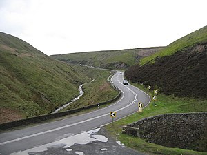
| The A57 at Snake Pass (photo 2007) | |
The A57 road ( English for road A57 ) is a 197 km long, partly designated as a primary route road in England, which connects Liverpool with Lincoln .
course
The road begins in the center of Liverpool and heads east via Huyton and Prescot , crossing the M57 motorway and the M62 motorway , to Warrington . There the A49 road is crossed. East of this city, the M6 motorway is crossed at junction 21 . The continuation runs via Salford into the center of Manchester , where a short section is designated as the A57 (M) motorway . When crossing Manchester, the M60 motorway ring road is crossed twice. East of Manchester, the road runs parallel to the M67 motorway into Longdendale. Further east, it rises to Snake Pass in the Peak District to an altitude of 512 m. The descent to Sheffield runs through the Peak District National Park . From Sheffield, where the A61 road is crossed, the road becomes the primary route and crosses the M1 motorway at junction 31 . The A57 bypasses Worksop and crosses the A60 road . In its further course to the east-southeast, it meets the A1 road south of Ranby and joins it as far as Markham Moor. She then crosses the River Trent . West of Lincoln it crosses this city's bypass on the A46 road and ends in the center of Lincoln on the A15 road .

