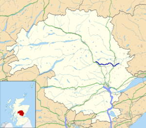
A984 road
| A984 road in the UK | |
| map | |
| Basic data | |
| Operator: | |
| Start of the street: |
Dunkeld ( 56 ° 34 ′ N , 3 ° 35 ′ W ) |
| End of street: |
Coupar Angus ( 56 ° 33 ′ N , 3 ° 17 ′ W ) |
| Overall length: | 21.8 km (13.5 mi ) |
| Entrance to Caputh | |
|
Course of the road
|
|
The A984 road is an A-road in Scotland . Starting in Dunkeld , it runs through the rural regions of the Council Area Perth and Kinross to Coupar Angus .
course
In the west, the road begins as a junction of the A923 in Dunkeld, directly north of the listed Dunkeld Bridge over the Tay . The A923 crosses the A9 directly south of Dunkeld and indirectly connects the A984 to this major trunk road. It initially largely follows the course of the Tay in an easterly direction and intersects the towns of Caputh , Spittalfield and Meikleour . On this section the B947 and the B9099 branch off from the A984. Beyond Meikleour, the A93 crosses and the road now follows the course of the Isla . It crosses Lunan Water and ends after a total length of 21.8 km north of Coupar Angus again on the A923.

