
Abu Simbel
| Abu Simbel in hieroglyphics | |||||||||||||||||||||||||
|---|---|---|---|---|---|---|---|---|---|---|---|---|---|---|---|---|---|---|---|---|---|---|---|---|---|
Pr Rˁ-msj-sw-mrj-Jmn p3-dmj The settlement of the house of Ramses , loved by Amun |
|||||||||||||||||||||||||
 |
|||||||||||||||||||||||||
Abu Simbel (also Abu Simbal , Ebsambul or Isambul ; Arabic أبو سنبل, DMG Abū Sinbal orأبو سمبل / Abū Simbal ) is a place in the Egyptian part of Nubia , about 240 kilometers southwest of Aswan . The town, which has only a little over 2600 inhabitants (calculation: 2012) is known for the fact that it was here in the 13th century BC. Built rock temple of the king ( pharaoh ) Ramses II from the 19th dynasty of the ancient Egyptian New Kingdom .
The temple of Abu Simbel , the great temple to the glory of Ramses II. And the small Hathor Temple in memory of Nefertari , the Great Royal Wife , stand on the 1979 World Heritage List of UNESCO . After being relocated in the 1960s, they rise today on an island in Lake Nasser , which is connected to the town of Abu Simbel on the northwest side by a navigable dam .
Surname
The name Abu Simbel is a European corruption , partly achieved by assimilation , of the Arabic Abu Sunbul , a derivation from the ancient place name Ipsambul . During the time of the New Kingdom kings, the region where the temples were built was believed to be called Meha . However, a secure assignment has not yet been made. About 20 km southwest of Abu-Simbel was the small village of Ibschek , which was a little north of the second Nile cataract , in today's Sudan ( Wadi Halfa Salient ) flooded by Lake Nubia , near the border with Egypt .
Location and climate
Coordinates: 22 ° 21 ' N , 31 ° 37' E

Abu Simbel is located in the south of Egypt not far from the border with Sudan . The place belongs administratively to the Aswan Governorate (Aswan) . The Sudanese border in the southwest is only about 20 kilometers away, it deviates from the 22nd parallel north and forms the Wadi Halfa Salient . However, the borderline is controversial, Egypt claims the area of Wadi Halfa Salient to the south to the 22nd parallel. The closest city, Wadi Halfa , is located 65 kilometers southwest of Abu Simbel on the territory of Sudan on the east bank of Lake Nubia , the Sudanese name for Lake Nasser. Like the temples of Abu Simbel, the city was moved to higher ground due to the flooding of the Nile Valley by the reservoir.
Abu Simbel is connected to the governorate capital, Aswan, by a road that runs west of Lake Nasser through the Libyan desert . It is mainly used by tourist buses that take visitors to the two temples of Abu Simbel, but is also important for the irrigation projects of the part of the desert near the reservoir. Lake Nasser is navigable, so Abu Simbel can also be approached from the sea side. Some cruise ships only use the lake above the Aswan High Dam. The place can be reached by air through Abu Simbel Airport .
Abu Simbel is located in one of the warmest and driest regions in Egypt. In the summer months, the maximum temperatures are a good 40 ° C on average . Despite the large temperature differences between day and night, the values rarely fall below 20 ° C in summer. The winters are mild with highs around 25 ° C, with temperatures sometimes falling below 10 ° C at night. Precipitation is so rare here that it is not possible to specify a “rainy season” for Abu Simbel.
history
In the past, Abu Simbel was on the west bank of the Nile between the first and second cataracts . Cataracts are rapids structured by blocks or rock bars ; they were difficult to pass for navigation on the Nile, especially at low tide . Today the two mentioned cataracts near Aswan and Wadi Halfa have sunk in Lake Nasser, which is named after Gamal Abdel Nasser , the former Egyptian president from 1954 to 1970. At the time of Ramses II, the southern border of the Pharaonic Empire was near the second cataract. The construction of the temple complexes of Abu Simbel there was intended to demonstrate the power and eternal superiority of Egypt over tributary Nubia.
The whole of Lower Nubia was flooded by the new reservoir, the residents were homeless and largely resettled in the Aswan and Kom Ombo areas . Only in Abu Simbel was there a new place with a hotel and an airport. Due to the lack of agricultural land, the entire population lives from tourism today. However, since the turn of the millennium, various projects have been running with the aim of making the high-altitude desert regions fertile with water from the lake.
 Abu Simbel Airport
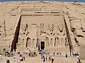 Great Temple of Ramses II
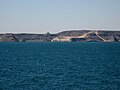 Lake Nasser near the temple complex

_03.jpg)
_02.jpg)

literature
- Lisa A. Heidorn: Abu Simbel. In: Kathryn A. Bard (Ed.): Encyclopedia of the Archeology of Ancient Egypt. Routledge, London 1999, ISBN 0-415-18589-0 , pp. 87-90.
Web links
Individual evidence
- ^ Rainer Hannig: Large Concise Dictionary Egyptian-German: (2800-950 BC) . P. 1143.
- ↑ World Gazetteer - Egypt: The most important places with statistics on their population. ( Memento from April 12, 2013 in the web archive archive.today ).
- ^ Noelle Watson: International Dictionary of Historic Places, Volume 4 - Middle East and Africa , Fitzroy Dearborn Publishers 1996, p.16 , ISBN 1-884964-03-6
- ^ Rainer Hannig: Large Concise Dictionary Egyptian-German: (2800-950 BC) . von Zabern, Mainz 2006, ISBN 3-8053-1771-9 , p. 1110.