Aguaytía
| Aguaytía | ||
|---|---|---|
|
|
||
| Coordinates | 9 ° 2 ′ S , 75 ° 30 ′ W | |
| Basic data | ||
| Country | Peru | |
| Ucayali | ||
| province | Padre Abad | |
| ISO 3166-2 | PE-UCA | |
| District | Padre Abad | |
| height | 287 m | |
| Residents | 15,587 (2017) | |
| founding | 1961 | |
| Website | munimala.gob.pe (Spanish) | |
| politics | ||
| mayor | Román Tenazoa Secas (2019-2022) |
|
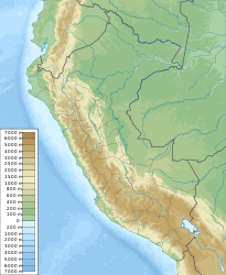
Aguaytía is the capital of the Padre Abad province in the Ucayali region of central Peru . The city is the administrative seat of the Padre Abad district . The 2017 census counted 15,587 residents, 10 years earlier the population was 13,363.
Geographical location
The city of Aguaytía is located about 375 km northeast of the state capital Lima . It is located on the Río Aguaytía on the western edge of the Amazon lowlands at an altitude of 287 m . To the west of the city rise the ridges of the Peruvian Eastern Cordillera . At Aguaytía there is a road bridge over the Río Aguaytía. The national road 5N, which connects the river valley of the Río Huallaga in the west with the regional capital Pucallpa on the Río Ucayali , leads over this .
Individual evidence
- ↑ Peru: Ucayali Region - Provinces & Places . www.citypopulation.de. Retrieved January 13, 2020.
Web links
Commons : Aguaytía - collection of images, videos and audio files

