Padre Abad Province
| Padre Abad Province | |
|---|---|
 Location of the province in the Ucayali region |
|
| Basic data | |
| Country | Peru |
| region | Ucayali |
| Seat | Aguaytía |
| surface | 8823 km² |
| Residents | 60,107 (2017) |
| density | 6.8 inhabitants per km² |
| founding | June 1, 1982 |
| ISO 3166-2 | PE-UCA |
| Website | www.munipadreabad.gob.pe (Spanish) |
| politics | |
| Alcalde Provincial | Román Tenazoa Secas (2019-2022) |
| Aguaytía | |
Coordinates: 8 ° 46 ′ S , 75 ° 27 ′ W
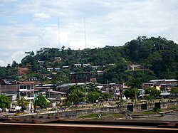
The Padre Abad Province is located in the Ucayali region in eastern Peru . The province has an area of 8823 km². At the 2017 census, 60,107 people lived in the province. In 1993 the population was 35,539, in 2007 it was 50,590. The province was named after Alonso Abad († 1788), a missionary of the Franciscan order . The administrative center is the city of Aguaytía , located on the Aguaytía River .
Geographical location
Padre Abad Province is located in the northwest of the Ucayali region. It extends over the Amazon lowlands. It has a lengthwise extension in SW-NE direction of about 110 km and a width of about 90 km. The province extends in the west to the Cordillera Azul , a mountain range of the Peruvian Eastern Cordillera . The Río Aguaytía drains the province in a northeastern direction to the Río Ucayali .
The province of Padre Abad borders on the province of Coronel Portillo to the east, the Huánuco region to the south and west and the Loreto region to the north .
Administrative division
The province of Padre Abad is divided into the following five districts. The Padre Abad district is the seat of the provincial administration.
| District | Administrative headquarters |
|---|---|
| Alexander von Humboldt | Alexander von Humboldt |
| Curimaná | Curimaná |
| Irazola | San Alejandro |
| Neshuya | Monte Alegre |
| Padre Abad | Aguaytía |
Individual evidence
- ↑ a b Padre Abad, Province in Ucayali Region . www.citypopulation.de. Retrieved November 30, 2019.
