Ak-Buura
|
Ak-Buura - Oqburasoy Ак-Буура |
||
|
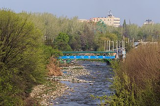
Ak-Buura in the center of Osh |
||
| Data | ||
| location |
Osh ( Kyrgyzstan ), Andijon ( Uzbekistan ) |
|
| River system | Syr Darya | |
| Drain over | Arawansai → Qoradaryo → Syrdarya → Aral Sea | |
| source | Northern slope of the Alai Mountains 39 ° 49 ′ 29 ″ N , 72 ° 32 ′ 32 ″ E |
|
| muzzle | Introduction to the Arawansai coordinates: 40 ° 37 '36 " N , 72 ° 21' 34" E 40 ° 37 '36 " N , 72 ° 21' 34" E
|
|
| length | 148 km | |
| Catchment area | 2540 km² | |
| Drain |
MQ |
21.4 m³ / s |
| Reservoirs flowed through | Papan dam | |
| Big cities | Osh | |
| Medium-sized cities | Xo'jaobod | |
The Ak-Buura ( Kyrgyz Ак-Буура ; Uzbek Oqburasoy ) is a river in Central Asia . It has a length of 148 km and flows through Kyrgyzstan and Uzbekistan . Its catchment area covers 2540 km², the mean discharge is 21.4 m³ / s.
course
The Ak-Buura rises on the northern slope of the Alai Mountains . Initially it flows in an east-northeast direction through the mountains. Later he turns north. It is dammed up to the Papan reservoir . The river flows through the regional capital Osh , turns to the northwest and crosses the border into Uzbekistan. He crosses south of Xo'jaobod the Southern Ferghanakanal .
Originally, the Ak-Buura cut a low ridge to flow into the lowlands of the Ferghana Valley and to Andijon . Today the Ak-Buura is diverted north of Xoʻjaobod over the Shahrixonsoy to the west to the Arawansai .
