Zgërdhesh
Zgërdhesh ( Albanian also Zgërdheshi ) is an archaeological site in Albania east of Fushë-Kruja .
Zgërdhesh used to be the name of a village. The village at this point is now known as Halilaj (often also Halil / Halili ); Zgërdhesh no longer exists as an independent village. Zgërdhesh is now only used to refer to the ancient site. This is possibly the ancient Albanopolis .
The village of Halilaj with Zgërdhesh is one of 100 villages in which the Albanian government wants to specifically promote tourism .
geography
Zgërdhesh is around four kilometers east of Fushë-Kruja and around 20 kilometers north of Tirana. The road from Fushë-Kruja to Kruja passes Halilaj north of Zgërdhesh. A spur road leads south towards Zgërdhesh.
In Halilaj the flat plain, which extends from Tirana via Fushë-Kruja to the north to the sea , merges into the Skanderbeg Mountains . Part of the village is on the flat at around 120 m above sea level. A. , other houses already on the slopes of the hills.
The Bërdhar brook flows through the village, coming down from the western flank of Mali i Krujës ( 1176 m above sea level ). Another, somewhat larger stream, the Zilla , runs a little north and emerges from the mountains on the road to Kruja. Both streams have formed deep valleys. Three small reservoirs for irrigation purposes lie south and west of the village.
The archaeological site is located on the south-eastern outskirts south of the Bërdhar stream near the hamlet of Kakariq . It starts from the summit of a range of hills that slopes north and south to the deeply cut streams. In the east it is connected to the mountain by a narrow ridge. Towards the west, a slope that becomes less steep and broader at the bottom forms on which the ancient city emerged. The difference in height between the lower outskirts and the hilltop is around 100 meters. At the lower end of the slope are the houses of a courtyard. The area is heavily overgrown in the upper area and in the lower grazing area, which is interspersed with several prickly hedges.
Halilaj village (Zgërdhesh)
In the mid-1980s, Zgërdhesh was described as a village with two primary schools, a cultural building and an infirmary. There were olive and fruit tree cultures.
From the 1990s Halilaj was known for its lime distilleries . The kilns in which the locally mined lime was burned were often fired with rubbish. The lime kilns were closed in 2019 after residents had complained about the conditions for a long time.
history
Antiquity
Zgërdhesh puzzles archaeologists and historians as it is not mentioned in historical sources. Some historians, Albanian in particular, suspect that it is the ancient Albanopolis mentioned by Ptolemy . This thesis has not yet been verified by excavation finds. In addition, the city was deserted when Albanopolis was mentioned.
Finds from the early Iron Age were made on the hilltop ; the settlement was founded in the 7th or 6th century BC. Founded. In the 4th and 3rd centuries BC An important Illyrian settlement emerged. In the 2nd century BC BC the place expanded over the walls into the foreland. The Illyrian Wars in the 3rd century BC BC initiated the decline of the city: It experienced as a result of the Roman conquest of the region in the 2nd century BC. A sharp decline - the archaeologists found no evidence of major economic activities. However, it was not completely abandoned until late Roman times.
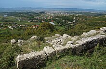
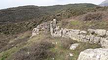
The ancient city is divided into several parts with different construction phases. The acropolis or upper town on the top of the hill with an area of one hectare is the original settlement. The lower town covers the western slope of the hill. The walls covered an area of 10 hectares. The acropolis has typical features for the 6th century BC. BC (minimally hewn stone blocks). A large part of the enclosing walls (still clearly visible at the lower end) and the towers of the Acropolis and other important buildings were built from rectangular stone blocks. The defensive walls are 1350 meters long. Terraces can still be seen on the city grounds. Stairs lead up the hill as urban traffic axes. Hardly any remains have been found in the Acropolis, the oldest part of the city; The wall in the east with a tower on the northeast corner is striking. The western wall is also well preserved with two entrances. There were drainage channels that led the water to cisterns.
There are stamps from at least five distilleries for roof tiles . In other workshops, amphorae , terracotta ceramics and dishes were made. It is believed that these are local products - as with the Illyrian helmet that was found . Trade relations existed in particular with Dyrrachium ( Durrës ), such as numerous coins from the 4th to 2nd centuries BC. Prove. Other significant discoveries that bear witness to the cultural life in the city are a statue of Artemis and well-preserved terracotta ceramics with ornaments.
At the entrance to the Acropolis, the foundation of an early Christian chapel was excavated. The small building is an indication that the site was used in some form in the following centuries.
Surname
The toponym Zgërdhesh was first mentioned in 1431 in an Ottoman document as Ozgurtaè . Later, in 1641, it appears in Marco Scura's chronicles as Sgurdessi .
literature
- Selim Islami: Qyteti ilir në Zgërdhesh . In: Instituti i Monumenteve të Kulturës (ed.): Monumentet . No. 1 . Tirana 1971, p. 23–42 ( imk.gov.al [accessed January 26, 2020]).
Web links
Individual evidence
- ↑ Baki Dollma: Vende dhe ngjarje historike të Krujës e Kurbinit . Dajti 2000, Tirana 2006, ISBN 99943-815-6-3 , pp. 116 .
- ↑ a b Akademia e Shkencave e RPSSH (ed.): Fjalor enciklopedik shqiptar . Tirana 1985, keyword Zgërdheshi , p. 1200 .
- ↑ Akademia e Shkencave e RPSSH (ed.): Fjalor enciklopedik shqiptar . Tirana 1985, keyword Kruja (rrethi) , p. 555 .
- ↑ Official map 1: 50,000 of the military cartographic office of Albania, sheet K-34-88-D Tirana e veriut , 3rd edition 1990.
- ↑ Bashkia Fushë Kruja: Rreth Fushë Krujës ( Memento from December 31, 2011 in the Internet Archive )
- ↑ Edi Beshi: Vështrimi Fiziko-Gjeografik i Qytetit të Fushë-Krujës në përgjithësi dhe gjeologjiko-inxhinierik në vecanti . July 2012, p. 10 ( academia.edu [accessed January 25, 2020]).
- ↑ Arba Baxhaku et. al .: Rajoni 06: Fshati Zgërdhesh . Ed .: Akademia 100+ Fshatrat, Bashkia Tirana, Programi 100 Fshatrat. Tirana, S. 15 ( kruja.gov.al [PDF; accessed January 25, 2020]).
- ↑ Qyteti i lashtë nga mendohet se ka rrjedhur emri i shqiptarëve. In: GazetaExpress. April 21, 2019, accessed January 22, 2020 (Albanian).
- ↑ a b c d Selim Islami: Qyteti ilir në Zgërdhesh . In: Instituti i Monumenteve të Kulturës (ed.): Monumentet . No. 1 . Tirana 1971, p. 23–42 ( imk.gov.al [accessed January 26, 2020]).
- ↑ a b c d e f g h Oliver Gilkes: Albania. An Archaeological Guide . IBTauris, London 2013, ISBN 978-1-78076-069-8 , Zgerdhesh (Albanopolis?), Pp. 311-313 .
- ↑ a b c d e Christian Zindel: Zgërdhesh . In: Christian Zindel, Andreas Lippert , Bashkim Lahi, Machiel Kiel (eds.): Albania. An archeology and art guide from the Stone Age to the 19th century . Böhlau, Vienna 2018, ISBN 978-3-205-20723-8 , pp. 485-488 .
- ↑ Krujë, mbyllet gropa e furrës gelqerore, Klosi: Guroret do spostohen. In: Balkanweb.com. April 4, 2019, accessed January 25, 2020 (Albanian).
- ↑ Krujë, djegia e mbetjeve urbane, kryeplaku Halili: Ka rrezikshmëri sëmundjesh. In: Shqiptarja.com. August 16, 2018, accessed January 25, 2020 (Albanian).
- ^ A b c Robert Elsie : Historical Dictionary of Albania . In: Historical dictionaries of Europe . No. 75 . Rowman & Littlefield, 2010, keyword Zgërdhesh , p. 497 f .
- ↑ In Elsie wrongly Pliny the Elder .
- ↑ Neritan Ceka : The Illyrians to the Albanians . Migjeni, Tirana 2005, ISBN 99943-672-2-6 , p. 210 .
Coordinates: 41 ° 28 ′ 31.9 ″ N , 19 ° 46 ′ 33 ″ E


