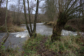
Altefeld (river)
| Altefeld / Altfell | ||
| Data | ||
| Water code | EN : 424 | |
| location | Vogelsbergkreis and District of Fulda , Hesse , Germany | |
| River system | Weser | |
| Drain over | Schlitz → Fulda → Weser → North Sea | |
| source | in Vogelsberg am Berg Taufstein 50 ° 30 ′ 48 ″ N , 9 ° 15 ′ 35 ″ E |
|
| Source height | approx. 637 m above sea level NN | |
| confluence | with the Lauter to Schlitz in Bad Salzschlirf Coordinates: 50 ° 37 ′ 40 ″ N , 9 ° 30 ′ 16 ″ E 50 ° 37 ′ 40 ″ N , 9 ° 30 ′ 16 ″ E |
|
| Mouth height | 238.7 m above sea level NN | |
| Height difference | approx. 398.3 m | |
| Bottom slope | approx. 13 ‰ | |
| length | 30 km | |
| Catchment area | 135.222 km² | |
| Discharge at the Schlechtenwegen A Eo gauge : 29.1 km² Location: 16 km above the estuary |
NNQ (08/24/1973) MNQ 1972/2012 MQ 1972/2012 Mq 1972/2012 MHQ 1972/2012 HHQ (02/07/1984) |
10 l / s 38 l / s 527 l / s 18.1 l / (s km²) 17.2 m³ / s 49 m³ / s |
| Discharge (extrapolated) A Eo : 88.49 km² Location: 12.4 km above the mouth |
MNQ 1961/1990 MQ 1961/1990 Mq 1961/1990 |
175 l / s 1.523 m³ / s 17.2 l / (s km²) |
| Discharge at the Bad Salzschlirf A Eo gauge : 135 km² Location: 500 m above the mouth |
NNQ (07/04/1976) MNQ 1965/2012 MQ 1965/2012 Mq 1965/2012 MHQ 1965/2012 HHQ (12/25/1967) |
40 l / s 179 l / s 1.69 m³ / s 12.5 l / (s km²) 42.9 m³ / s 111 m³ / s |
| Left tributaries | Alte Hasel , Mühlenbach | |
|
The confluence of the Alte Hasel (from left) near Stockhausen |
||
The Altefeld forms the right or southwestern source river of the Schlitz and flows through the Vogelsbergkreis and the Fulda district in Hesse , Germany . In the upper reaches it is called the Schwarzer Fluss or Schwarzbach , later Altfell . It is a total of 30.0 km long, its catchment area covers 135.222 km².
course
The Altefeld rises under the name Black River on the eastern flank of the 773 m above sea level. NN high Taufstein in Vogelsberg . The source is around 637 m above sea level. NN high within the Vogelsbergkreis and the nature park Hoher Vogelsberg in the Köhlerwald near Urborn . The Black River flows eastwards and soon takes on other, sometimes longer, source streams.
After leaving the forest area, the Black River flows through Hochwaldhausen and Ilbeshausen , which are combined as the district of Ilbeshausen-Hochwaldhausen in the larger municipality of Grebenhain . Below Ilbeshausen, the small Haselbach joins from the left . Here the river changes its name to Altfell and flows through Altenschlirf . Below Altenschlirf, it takes the final name Altefeld and next flows through the village of Schlechtenwegen .
At Stockhausen the Altefeld takes on its largest tributary from the left, the Alte Hasel , crosses Stockhausen, leaves the nature park and then in a north-easterly direction reaches Müs , a district of Großenlüder .
After the mouth of the Mühlenbach on the left , the Altefeld continues northwards through Bad Salzschlirf , where it rises to 238.7 m above sea level. NN combined with the Lauter to Schlitz coming from the west , which flows into the Fulda after 13.3 km from the left .
Web links
Individual evidence
- ↑ a b c d Map services of the Federal Agency for Nature Conservation ( information )
- ↑ a b c d e f Water map service of the Hessian Ministry for the Environment, Climate Protection, Agriculture and Consumer Protection ( information )
- ↑ 43.3 km - 13.3 km ("Schlitz" length) = 30.0 km
- ^ Deutsches Gewässerkundliches Jahrbuch Weser-Ems 2012. Lower Saxony State Office for Water Management, Coastal and Nature Conservation, p. 132, accessed on October 4, 2017 (PDF, German, 6523 kB).
- ↑ up to and including the mouth of the Old Hasel
- ↑ The MNQ values cover the 20-year period 1979/1998.
- ^ Deutsches Gewässerkundliches Jahrbuch Weser-Ems 2012. Lower Saxony State Agency for Water Management, Coastal Protection and Nature Conservation, p. 133, accessed on October 4, 2017 (PDF, German, 6523 kB).

