Alum Creek (Big Walnut Creek)
| Alum Creek | ||
|
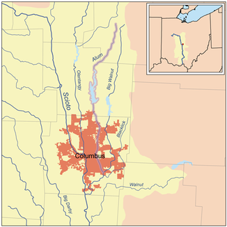
Alum Creek within the Scioto River basin |
||
| Data | ||
| Water code | US : 1066550 | |
| location | North Central Ohio, USA | |
| River system | Mississippi River | |
| Drain over | Big Walnut Creek → Scioto River → Ohio River → Atlantic Ocean | |
| origin | 2 km southwest of Mount Gilead in Morrow County 40 ° 32′0 ″ N , 82 ° 49′2 ″ W |
|
| Source height | 350 m | |
| muzzle | Big Walnut Creek near Obetz, Ohio Coordinates: 39 ° 52 '52 " N , 82 ° 54' 27" W 39 ° 52 '52 " N , 82 ° 54' 27" W. |
|
| Mouth height | 219 m | |
| Height difference | 131 m | |
| Bottom slope | 1.4 ‰ | |
| length | 93 km | |
| Catchment area | 320 km² | |
| Reservoirs flowed through | Alum Creek Lake | |
| Big cities | Columbus | |
|
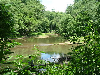
Alum Creek and Big Walnut Creek confluence |
||
The Alum Creek is a 93 km long tributary of the Big Walnut Creek in the central US state of Ohio . The river has its source at Mount Gilead in Morrow County and then flows mainly in a southerly direction through predominantly agricultural area. It forms Alum Creek Lake and flows south of Columbus into Big Walnut Creek, a tributary of the Scioto River . Alum Creek Lake was dammed in 1974 as a drinking water reservoir for the city of Columbus and has a surface area of around 13.7 km². In addition, the dam protects against flooding in the southern area of the river.
In the valley of the Alum Creek, traces of the prehistoric Adena culture have been discovered, dating from around 1000 BC. Until 200 AD was resident here. Seven mounds from this time have been identified along the river . In the 18th century there were some Delaware riverside villages that lived there for a while on their way west. One of the first European settlers was Colonel Moses Byxbe , who owned around 150 km² of land on the river.
During the war of 1812 , residents of the area built four log houses for defense. One of them was right by the river. Fort Cheshire was a two-story log cabin with loopholes for defense . Hot water could be poured onto the attackers from the protruding second floor. The building later served as a school and was intact until the American Civil War . A bronze plate reminds of the fort today at the former location.
At the beginning of the 19th century, the so-called Underground Railway , as the escape route for escaped slaves from the south was called, ran along Alum Creek . Up to 40,000 former slaves are said to have been released on various routes of the Underground Railway. The Africa Road near the river got its name because a nearby settlement had taken in 30 former slaves from North Carolina .
Name variants
The river has several designations:
- Allum Creek
- Elk Creek
- Salt Creek
- Seckle Creek
- Sepung Creek
Individual evidence
- ↑ a b Google Earth altitude for GNIS coordinates, accessed on July 24, 2010.
- ^ A b Alum Creek (Big Walnut Creek) in the Geographic Names Information System of the United States Geological Survey
- ↑ a b c d Alum Creek. Archived from the original on August 3, 2013 ; Retrieved July 24, 2010 .
- ↑ a b c d Richmond, W. Edson. Place-Names in Franklin County, Ohio . Ohio State Archaeological and Historical Quarterly v.53 (April, 1944) pp.135-159. p145
- ^ Doctor HF Raup Ohio Place Names Research File
Web links
- Alum Creek ( Memento from August 3, 2013 in the Internet Archive )
- Friends of Alum Creek
- Alum Creek (Big Walnut Creek) in the Geographic Names Information System of the United States Geological Survey

