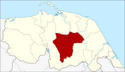
Amphoe Mayo
|
Mayo มายอ |
|
|---|---|
| Province: | Pattani |
| Surface: | 216.1 km² |
| Residents: | 56,808 (2012) |
| Population density : | 245.6 U / km² |
| ZIP : | 94140, 94190 |
| Geocode : | 9405 |
| map | |

|
|
Amphoe Mayo ( Thai : อำเภอ มายอ ) is a district ( amphoe - administrative district) in the central area of Pattani Province and is the only amphoe that has no border with other provinces or the coast. The Pattani Province is located in the southeast of the southern region of Thailand on the Gulf of Thailand .
geography
Neighboring counties and areas are (clockwise from north): Amphoe Yaring , Panare , Thung Yang Daeng and Yarang . All Amphoe are in Pattani Province.
history
The area of today's Mayo County was originally part of Amphoe Yaring . The district was established in 1900, initially under the name Rako ( รา เกาะ ). The following year, when the new administration building opened in Tambon Mayo, the district was named after the central Tambon Mayo.
administration
Provincial Administration
Amphoe Mayo is divided into 13 subdistricts ( tambon ) , which are further subdivided into 58 village communities ( muban ) .
| No. | Surname | Thai | Muban | Pop. |
|---|---|---|---|---|
| 1. | Mayo | มายอ | 3 | 6,017 |
| 2. | Thanon | ถนน | 4th | 3,676 |
| 3. | Trang | ตรัง | 4th | 2,933 |
| 4th | Krawa | กระ หวะ | 5 | 3,391 |
| 5. | Lubo Yirai | ลุ โบะ ยิ ไร | 8th | 10,667 |
| 6th | La-nga | ลา งา | 7th | 6,395 |
| 7th | Kraso | กระ เสาะ | 5 | 3,443 |
| 8th. | Ko Chan | เกาะ จัน | 5 | 4,646 |
| 9. | Pado | ปะ โด | 4th | 4,705 |
| 10. | Sakho Bon | สา คอ บน | 3 | 3,096 |
| 11. | Sakho Tai | สา คอ ใต้ | 4th | 1,981 |
| 12. | Sakam | สะ กำ | 4th | 4.183 |
| 13. | Panan | ปา นั น | 2 | 1,675 |
Local administration
Mayo ( เทศบาล ตำบล มายอ ) is a small town ( Thesaban Tambon ) in the district, it consists of the entire Tambon Mayo.
Each of the remaining ten tambon is administered by a “tambon administration organization” (TAO, องค์การ บริหาร ส่วน ตำบล ).
Individual evidence
- ↑ Population statistics 2012 . Department of Provincial Administration. Retrieved March 21, 2014.
Web links
Coordinates: 6 ° 43 ' N , 101 ° 25' E
