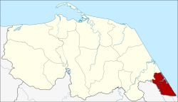
Amphoe Mai Kaen
|
Mai Kaen ไม้แก่น |
|
|---|---|
| Province: | Pattani |
| Surface: | 55,201 km² |
| Residents: | 11,979 (2012) |
| Population density : | 204.1 U / km² |
| ZIP : | 94220 |
| Geocode : | 9408 |
| map | |

|
|
Amphoe Mai Kaen ( Thai : อำเภอ ไม้แก่น ) is the southernmost district ( Amphoe - administrative district) of the Pattani Province . The Pattani Province is located in the southeast of the southern region of Thailand .
geography
Adjacent counties and areas are (from south clockwise): Amphoe Mueang Narathiwat and Bacho of Narathiwat province and Amphoe Sai Buri in Pattani Province. To the east lies the Gulf of Thailand .
history
Mae Kaen was initially set up as a subdistrict ( King Amphoe ) on November 15, 1973 by separating the two tambon Sai Thong and Mai Kaen from the Sai Buri district . On July 4, 1994, Mae Kaen was granted full amphoe status.
administration
Provincial Administration
Amphoe Mai Kaen is divided into four subdistricts ( tambon ) , which are further subdivided into 17 village communities ( muban ) .
| No. | Surname | Thai | Villages | Pop. |
|---|---|---|---|---|
| 1. | Sai Thong | ไทรทอง | 5 | 4,606 |
| 2. | Mai Kaen | ไม้แก่น | 4th | 1,896 |
| 3. | Talo Kraithong | ตะ โละ ไกร ทอง | 4th | 2,459 |
| 4th | Don Sai | ดอน ทราย | 4th | 3,018 |
Local administration
Each of the three tambon is administered by a "tambon administration organization" (TAO, องค์การ บริหาร ส่วน ตำบล ).
Individual evidence
- ↑ ประกาศ กระทรวง มหาดไทย เรื่อง แบ่ง ท้องที่ อำเภอ สายบุรี จังหวัด ปัตตานี ตั้ง เป็น กิ่ง อำเภอ ไม้แก่น Royal Gazette, Volume 90, Ed. 147 ง of November 20, 1973, p. 3826 (in Thai)
- ↑ พระราชกฤษฎีกา ตั้ง อำเภอ เปือยน้อย… และ อำเภอ ศรีวิไล พ.ศ. ๒๕๓๗ Royal Gazette, Vol. 111, Ed. 21 ก June 3, 1994, pp. 32–35 (in Thai)
- ↑ Population statistics 2012 . Department of Provincial Administration. Retrieved July 11, 2014.
Web links
Coordinates: 6 ° 37 ' N , 101 ° 40' E
