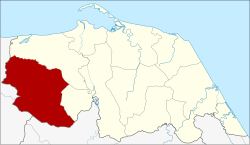
Amphoe Khok Pho
|
Khok Pho โคกโพธิ์ |
|
|---|---|
| Province: | Pattani |
| Surface: | 64,329 km² |
| Residents: | 66,269 (2012) |
| Population density : | 189.5 U / km² |
| ZIP : | 94120, 94180 |
| Geocode : | 9402 |
| map | |

|
|
Amphoe Khok Pho ( Thai : อำเภอ โคกโพธิ์ ) is a district ( Amphoe - administrative district) in Pattani Province . The Pattani Province is located in the southeast of the southern region of Thailand on the Gulf of Thailand .
geography
Neighboring counties and areas are (clockwise from north): Amphoe Nong Chik and Mae Lan in Pattani Province, Amphoe Mueang Yala in Yala Province, and Amphoe Saba Yoi and Thepha in Songkhla Province .
The Namtok Sai Khao National Park ( อุทยานแห่งชาติ น้ำตก ทรายขาว ) is 110 km² in size in the forested hills of the Sankarakhiri Mountains, which extend over the provinces of Pattani, Yala and Songkhla.
history
The area of today's Khok Pho County originally belonged to the city-state ( Mueang ) Nong Chik, one of the seven provinces of the former Kingdom of Pattani . The circle was established by first separating it from Nong Chik Amphoe . His name at the time was Mueang Kao ( เมือง เก่า ). When the administration was later moved to Tambon Makrut, the district was named Makrut.
In 1929, King Prajadhipok (Rama VII) visited the district to observe a solar eclipse on May 9th . During his visit, he saw a building in Khok Pho that he thought would be better suited as a seat of administration. Therefore the administration was moved there shortly afterwards. In 1939 the district was given its current name Khok Pho.
Attractions
- Rama VII Pavilion - in the Tambon Khok Pho, built at the time for King Prajadhipok in order to be able to observe the solar eclipse.
- Wat Chang Hai Rat Buranaram ( วัด ช้าง ให้ สมเด็จ หลวง ปู่ทวด ) - Buddhist temple ( Wat ) in Tambon Thung Phala, allegedly built 300 years ago, with a large chedi in the "Sri Lankan style".
- Namtok Phong Phong ( น้ำตก โผง โผง , Phong Phong Waterfall ) - impressive waterfall in the Namtok Sai Khao National Park : it falls in seven steps into a small pond.
administration
Provincial Administration
Amphoe Khok Pho is divided into 12 subdistricts ( tambon ) , which are further subdivided into 81 village communities ( muban ) .
| No. | Surname | Thai | Villages | Pop. |
|---|---|---|---|---|
| 1. | Khok Pho | โคกโพธิ์ | 11 | 10,872 |
| 2. | Macrut | มะกรูด | 7th | 5,702 |
| 3. | Bang Kro | บาง โก ระ | 5 | 2,629 |
| 4th | Pa Bon | ป่า บอน | 6th | 3,935 |
| 5. | Sai Khao | ทรายขาว | 6th | 4.147 |
| 6th | Well Pradu | นา ประดู่ | 8th | 9,175 |
| 7th | Pak Lo | ปาก ล่อ | 9 | 6.171 |
| 8th. | Thung Phala | ทุ่ง พ ลา | 5 | 3,772 |
| 11. | Tha Ruea | ท่าเรือ | 6th | 4,832 |
| 13. | Well ket | นา เกตุ | 7th | 7,090 |
| 14th | Khuan Nori | ควน โนรี | 6th | 4,958 |
| 15th | Chang Hai Tok | ช้าง ให้ ตก | 5 | 2.986 |
Note: The missing numbers (geocodes) refer to the tambon that make up Amphoe Mae Lan .
Local administration
There are three small towns ( Thesaban Tambon ) in the county:
- Khok Pho ( เทศบาล ตำบล โคกโพธิ์ ) consists of parts of the tambon Khok Pho,
- Na Pradu ( เทศบาล ตำบล นา ประดู่ ) consists of parts of the Tambon Na Pradu,
- Makrut ( เทศบาล ตำบล มะกรูด ) consists of the whole Tambon Makrut.
There are also 11 “tambon administration organizations” (TAO, องค์การ บริหาร ส่วน ตำบล ) for the tambon or the parts of tambon in the county that do not belong to any town.
Individual evidence
- ↑ พระราชกฤษฎีกา เปลี่ยน นาม อำเภอ กิ่ง อำเภอ และ ตำบล บาง แห่ง พุทธศักราช ๒๔๘๒ Royal Gazette, Volume 56, Ed. 0 ก of April 17, 1939, pp. 354–364 (in Thai)
- ↑ Population statistics 2012 . Department of Provincial Administration. Retrieved July 11, 2014.
Web links
Coordinates: 6 ° 44 ' N , 101 ° 6' E
