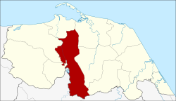
Yarang District
|
Yarang ยะรัง |
|
|---|---|
| Province: | Pattani |
| Surface: | 184.0 km² |
| Residents: | 83,031 (2012) |
| Population density : | 455.2 U / km² |
| ZIP : | 94160 |
| Geocode : | 9410 |
| map | |

|
|
Amphoe Yarang ( Thai : อำเภอ ยะรัง ) is a district ( amphoe - administrative district) in Pattani Province . The Pattani Province is located in the southeast of the southern region of Thailand on the Gulf of Thailand .
geography
Adjacent counties and areas are (from south clockwise): Amphoe Raman and Muang Yala of Yala province and Amphoe Mae Lan , Nong Chik , Mueang Pattani , Yaring , Mayo and Thung Yang Daeng Pattani Province.
history
The old administration building was in Ban Ano Bulo in Tambon Yarang. However, since this area was hit by floods every year, the government built a new building in Ban Bin Ya Limo in 1930. The current building was opened on September 22, 1996.
administration
Provincial Administration
Amphoe Yarang is divided into 12 subdistricts ( tambon ) , which are further subdivided into 72 village communities ( muban ) .
| No. | Surname | Thai | Muban | Pop. |
|---|---|---|---|---|
| 1. | Yarang | ยะรัง | 6th | 11,787 |
| 2. | Sadawa | สะ ดา วา | 8th | 7,694 |
| 3. | Prachan | ประจัน | 9 | 7,713 |
| 4th | Sano | สะ น อ | 4th | 4,922 |
| 5. | Rawaeng | ระ แว้ง | 6th | 4,437 |
| 6th | Pitu Mudi | ปิ ตู มุ ดี | 5 | 5,860 |
| 7th | Wat | วัด | 5 | 5,204 |
| 8th. | Krado | กระ โด | 5 | 4,594 |
| 9. | Khlong May | คลองใหม่ | 6th | 4,790 |
| 10 | Mo Mawi | เมาะ มา วี | 6th | 10,067 |
| 11. | Kolam | กอ ลำ | 5 | 5,848 |
| 12. | Khao Tum | เขา ตูม | 7th | 14,895 |
Local administration
Yarang ( เทศบาล ตำบล ยะรัง ) is a small town ( Thesaban Tambon ) in the district, it consists of parts of the Tambon Yarang and Pitu Mudi.
There are also twelve “tambon administrative organizations” (TAO, องค์การ บริหาร ส่วน ตำบล ) for the tambon or the parts of tambon in the county that do not belong to any town.
Individual evidence
- ↑ Population statistics 2012 . Department of Provincial Administration. Retrieved July 11, 2014.
Web links
Coordinates: 6 ° 46 ' N , 101 ° 18' E
