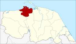
Amphoe Mueang Pattani
|
Mueang Pattani เมือง ปัตตานี |
|
|---|---|
| Province: | Pattani |
| Surface: | 96.869 km² |
| Residents: | 125,630 (2012) |
| Population density : | 1221.3 U / km² |
| ZIP : | 94000 |
| Geocode : | 9401 |
| map | |

|
|
Amphoe Mueang Pattani ( Thai : อำเภอ เมือง ปัตตานี ) is the central district ( Amphoe - administrative district) in the Province of Pattani . The Pattani Province is located in the southeast of the southern region of Thailand on the Gulf of Thailand .
Pattani is the capital of Mueang Pattani County and is also the capital of Pattani Province.
geography
Neighboring counties and areas are (clockwise from the east): Yaring , Yarang and Nong Chik districts . All Amphoe are in Pattani Province. To the north lies the Gulf of Thailand .
The main water resource of the district is the Maenam Pattani ( Pattani River , also called "Maenam Tani" - Tani River ).
history
The area of the county was the center of the Pattani Kingdom . During the reign of King Phutthaloetla (Rama II) , the Kingdom of Pattani was divided into seven city-states ( Müang ) at his behest in order to break the power of the often rebellious Sultan of Pattani. The mueang were Pattani, Yaha, Yaring, Nong Chik, Ra-ngae, Raman and Sai Buri. Pattani was officially designated a district in 1901. When King Chulalongkorn (Rama V) introduced the Monthon in 1906 as part of his thesaphiban administrative reform , Pattani was the central district of Monthon Pattani .
In April 2004, 32 suspected rebels holed up in the Krue Se Mosque, which is over two hundred years old . When Thai troops stormed the historic church, they were all shot. The event worsened the conflict between the state and separatists in southern Thailand .
education
A sub-campus of the Prince of Songkla University is located in Amphoe Mueang Pattani .
administration
Provincial Administration
Amphoe Mueang Pattani is divided into 13 subdistricts ( tambon ) , which are further subdivided into 66 village communities ( muban ) .
| No. | Surname | Thai | Muban | Pop. |
|---|---|---|---|---|
| 1. | Sabarang | สะ บา รัง | - | 24,915 |
| 2. | Anoru | อา เนาะ รู | - | 10,891 |
| 3. | Chabang Tiko | จะ บัง ติก อ | - | 8.003 |
| 4th | Bana | บา นา | 11 | 19,865 |
| 5. | Tanyong Lulo | ตันหยง ลุ โละ | 3 | 6,471 |
| 6th | Khlong Maning | คลอง มา นิง | 4th | 3,409 |
| 7th | Kamiyo | กะ มิ ย อ | 7th | 4,559 |
| 8th. | Barahom | บา รา โหม | 3 | 2,992 |
| 9. | Paka Harang | ปะ กา ฮะ รัง | 8th | 5,402 |
| 10. | Rusa Milae | รู สะ มิ แล | 6th | 17,815 |
| 11. | Talubo | ตะ ลุ โบะ | 9 | 7,257 |
| 12. | Baraho | บา รา เฮาะ | 8th | 7.141 |
| 13. | Puyut | ปุ ยุด | 7th | 6,911 |
Local administration
Pattani ( เทศบาล เมือง ปัตตานี ) is a city ( Thesaban Mueang ) in the district, it consists of the entire Tambon Sabarang, Anoru and Chabang Tiko.
Rusa Milae ( เทศบาล ตำบล รู สะ มิ แล ) is a small town ( Thesaban Tambon ) in the district, it consists of the entire Tambon Rusa Milae.
There are also nine “tambon administrative organizations” (TAO, องค์การ บริหาร ส่วน ตำบล ) for the tambon in the district that do not belong to any city.
Individual evidence
- ↑ Population statistics 2012 . Department of Provincial Administration. Retrieved July 8, 2014.
Web links
Coordinates: 6 ° 52 ' N , 101 ° 15' E

