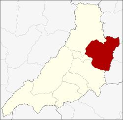
Rong Kwang district
|
Rong Kwang ร้องกวาง |
|
|---|---|
| Province: | Phrae |
| Surface: | 631.4 km² |
| Residents: | 50,392 (2012) |
| Population density : | 81.4 U / km² |
| ZIP : | 54140 |
| Geocode : | 5402 |
| map | |

|
|
Amphoe Rong Kwang ( Thai อำเภอ ร้องกวาง , pronunciation: ʔāmpʰɤ̄ː rɔ́ːŋ kwāːŋ ) is the easternmost district ( amphoe - administrative district) in the Phrae Province in northern Thailand .
geography
Neighboring districts (from southwest clockwise): the Amphoe Mueang Phrae , Nong Muang Khai and Song of the Phrae Province, and Wiang Sa , Na Noi and Na Muen of the Nan Province .
education
The Phrae sub- campus of Maejo University is located in Rong Kwang district .
administration
Provincial Administration
The district is divided into eleven municipalities ( tambon ) , which are further subdivided into 92 villages ( muban ) .
| No. | Surname | Thai | Muban | Pop. |
|---|---|---|---|---|
| 1. | Rong Kwang | ร้องกวาง | 12 | 6,942 |
| 4th | Rong Khem | ร้อง เข็ม | 9 | 5,043 |
| 5. | Nam Lao | น้ำ เลา | 10 | 5,465 |
| 6th | Ban Wiang | บ้าน เวียง | 14th | 7,425 |
| 7th | Thung Si | ทุ่ง ศรี | 15th | 3,196 |
| 8th. | Mae Yang Tan | แม่ ยาง ตาล | 10 | 4,844 |
| 9. | Mae Yang Ho | แม่ ยาง ฮ่อ | 5 | 3,099 |
| 10. | Phai Thon | ไผ่ โทน | 9 | 4.139 |
| 13. | Huai Rong | ห้วย โรง | 8th | 3,031 |
| 14th | Mae Sai | แม่ ทราย | 4th | 3,342 |
| 15th | Mae Yang Rong | แม่ ยาง ร้อง | 6th | 3,866 |
Missing numbers belong to tambon, which now form Nong Muang Khai County.
Local administration
There are two small towns ( Thesaban Tambon ) in the county:
- Rong Kwang (Thai: เทศบาล ตำบล ร้องกวาง ) consists of parts of the Tambon Rong Kwang, Rong Khem and Thung Si,
- Ban Wiang (Thai: เทศบาล ตำบล บ้าน เวียง ) consists of the entire tambon Ban Wiang.
There are also nine "Tambon Administrative Organizations" (TAO, องค์การ บริหาร ส่วน ตำบล - administrative organizations) for the tambon in the district that do not belong to any city.
Individual evidence
- ↑ Population statistics 2012 . Department of Provincial Administration. Retrieved April 8, 2014.
Web links
Coordinates: 18 ° 20 ′ N , 100 ° 19 ′ E
