Anson (Town, Chippewa County)
| Anson | ||
|---|---|---|
|
Location in Wisconsin
|
||
| Basic data | ||
| State : | United States | |
| State : | Wisconsin | |
| County : | Chippewa County | |
| Coordinates : | 44 ° 59 ′ N , 91 ° 17 ′ W | |
| Time zone : | Central ( UTC − 6 / −5 ) | |
|
Inhabitants : - Metropolitan Area : |
2,076 (as of 2010) 161,151 (as of 2010) |
|
| Population density : | 21.4 inhabitants per km 2 | |
| Area : | 102.4 km 2 (approx. 40 mi 2 ) of which 96.9 km 2 (approx. 37 mi 2 ) is land |
|
| Height : | 289 m | |
| Area code : | +1 715 | |
| FIPS : | 55-02175 | |
| GNIS ID : | 1560886 | |
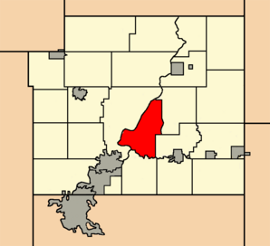
 Location of the Town of Anson in Chippewa County |
||
The Town of Anson is one of 23 towns in Chippewa County in the US state of Wisconsin . In 2010 the Town of Anson had 2,076 inhabitants.
Town has a fundamentally different meaning in Wisconsin than in the rest of the English-speaking area. Rather, it corresponds to the usual townships in the other US states , which form the next smaller administrative unit after the county .
geography
The Town of Anson is located in western Wisconsin and is bounded to the west and southwest by the Chippewa River , whose mouth into the Mississippi , which forms the border with Minnesota , is about 100 km to the southwest.
In the southwest of the Town of Anson, the Chippewa River is dammed up to form the 2,438 hectare Lake Wissota , on whose east bank Lake Wissota State Park is located.
The coordinates of the geographic center of the Town of Anson are 44 ° 58'51 "north latitude and 91 ° 17'13" west longitude. It extends over an area of 102.4 km², which is spread over 96.9 km² of land and 5.5 km² of water.
The Town of Anson is located in the southern center of Chippewa County and borders the following neighboring towns:
|
Town of Eagle Point |

|
Town of Arthur Town of Goetz |
| Town of Lafayette | Town of Sigel |
traffic
The County Highways K, S, O and Y run through the area of the Town of Anson. All other roads are subordinate country roads or partly unpaved roads.
In parallel with the WI 29 runs a railway line for freight traffic to the Canadian National Railway belonging Wisconsin Central .
The Old Abe State Trail runs along the Chippewa River . This is a combined hiking and cycling path known as a Rail Trail on the route of a disused railway line. Old Abe is the name of a bald eagle who was the mascot of the 8th Regiment of the Wisconsin Volunteer Infantry in the American Civil War .
The nearest airport is the Chippewa Valley Regional Airport in Eau Claire (around 25 km southwest).
population
According to the 2010 census , the Town of Anson had 2,076 people in 841 households. The population density was 21.4 inhabitants per square kilometer. Statistically, 2.47 people lived in each of the 841 households.
The racial the population was composed of 97.6 percent white, 0.4 percent African American, 0.3 percent Native American, 0.4 percent Asian and 0.2 percent from other ethnic groups; 1.1 percent were descended from two or more races. Regardless of ethnicity, 0.3 percent of the population was Hispanic or Latino of any race.
21.3 percent of the population were under 18 years old, 64.7 percent were between 18 and 64 and 14.0 percent were 65 years or older. 48.4 percent of the population was female.
The average annual income for a household was 63,347 USD . The per capita income was $ 29,170. 4.9 percent of the population lived below the poverty line.
Towns in the Town of Anson
In addition to scattered settlements, there are also the following non-parish settlements in the area of the Town of Anson :
Individual evidence
- ↑ a b American Fact Finder. Retrieved September 23, 2013
- ↑ Distance information according to Google Maps on Histopolis.com.Retrieved September 23, 2013
- ^ Wisconsin State Park System - Old Abe State Trail.Retrieved September 23, 2013
- ^ Wisconsin History - Feather from Old Abe the War Eagle. Retrieved September 23, 2013

