Antenna (river)
| antenna | ||
|
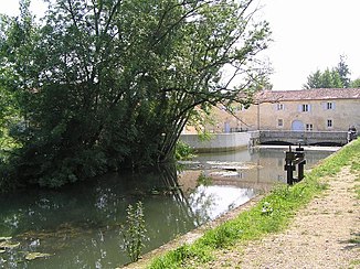
The antenna at the Préziers mill |
||
| Data | ||
| Water code | FR : R32-0430 | |
| location | France , Nouvelle-Aquitaine region | |
| River system | Charente | |
| Drain over | Charente → Atlantic Ocean | |
| source | at Fontaine-Chalendray 45 ° 57 ′ 3 ″ N , 0 ° 10 ′ 54 ″ W. |
|
| Source height | approx. 103 m | |
| muzzle | West of Cognac in the Charente Coordinates: 45 ° 40 ′ 51 ″ N , 0 ° 22 ′ 25 ″ W 45 ° 40 ′ 51 ″ N , 0 ° 22 ′ 25 ″ W |
|
| Mouth height | approx. 5 m | |
| Height difference | approx. 98 m | |
| Bottom slope | approx. 2 ‰ | |
| length | approx. 49 km | |
| Left tributaries | Briou | |
| Right tributaries | Saudrenne | |
The aerial is a river in France, in the Nouvelle-Aquitaine region . It has its source at Fontaine-Chalendray and crosses the Charente-Maritime and Charente departments . To the west of Cognac , the antenna joins the Charente as a right tributary after around 49 kilometers .
history
The name "antenna" comes from the pre-Celtic times. The valley was inhabited as early as the Paleolithic , as evidenced by the finds from the cave of Marcel Clouet in Javrezac from the time of the Moustérien (around 40,000 years ago).
natural reserve
In the middle and lower sections of the river, the river forms a natural landscape worth preserving, which is registered under Natura 2000 under code FR5400473.
Places on the river
- Fontaine-Chalendray
- Cressé
- Les Touches-de-Périgny
- Matha
- Prignac
- Le Seure
- Mesnac
- Saint-Sulpice-de-Cognac
- Cherves-Richemont
- Javrezac
Web links
Commons : The River Antenna - Collection of images, videos and audio files
- Syndicate for the care and maintenance of the river basin of the antenna (SYMBA)
- Natura 2000 description
