Aqua (satellite)
| Aqua | |
|---|---|

|
|
| Type: | Research satellite |
| Country: |
|
| Operator: |
|
| COSPAR-ID : | 2002-022A |
| Mission dates | |
| Begin: | May 4, 2002 |
| Starting place: | Vandenberg Air Force Base |
| Launcher: | Delta II |
| Status: | active |
| Orbit data | |
| Rotation time : | 98 minutes |
| Orbit inclination : | 98.2 ° |
| Apogee height : | 686 km |
| Perigee height : | 673 km |
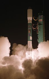
Aqua ( Latin for water ), and EOS-PM1 called, is a started on May 4, 2002 research satellite of the US air and space agency NASA , which the complex processes in the ecosystem of the earth to explore.
Aqua is part of the Earth Observing System (EOS), a multi-mission, long-term research program of NASA. The five satellites Aqua, Aura , CloudSat , PARASOL and CALIPSO together form the A-Train . Aqua cost $ 1 billion.
Orbit information
The satellite moves in a polar , sun-synchronous earth orbit . Thanks to this trajectory, Aqua and the Terra satellite, which was launched in 1999, complement each other, so that the same areas can be observed at different times of the day, for example to be able to track the amount of precipitation more precisely.
Its secondary name EOS-PM1 is derived from the fact that the satellite's equatorial passage time falls in the afternoon.
For example, he flew over the Aral Sea area in October 2002 and took pictures of it (see web link).
mission
Aqua's main mission objective is to obtain large amounts of information about evaporation , clouds and precipitation, the proportion of water vapor in the earth's atmosphere and aerosols , but also about the temperature of the water and the area of the sea and land ice . In addition, Aqua has the task of investigating changes in the currents in the oceans and should thus improve the understanding of the effects of clouds, surface water and its influence on the earth's climate .
This information is intended to improve forecasts of changes in the global ecosystem and global climate. The accuracy of weather forecasts should also be increased with the help of this satellite.
The satellite
Aqua has a size of 4.8 meters × 16.7 meters × 8.0 meters and a mass of 3,117 kg . 230 kilograms of fuel are also carried for course corrections. The large solar panel generates 4.4 kW of electrical power to supply the six scientific instruments with energy .
Instruments
Aqua is equipped with six measuring instruments that have different properties:
- AIRS
- ( A tmospheric I nfra r ed S ounder) is an advanced infrared measuring device that can obtain precise temperature and humidity profiles and a variety of other information about the atmosphere. This instrument has similar tasks as the AMSU and HSB instruments.
- AMSU
- A dvanced M icrowave S ounding U nit
- HSB
- H umidity S ounder for B razil
- CERES
- C louds and the E arth's R adiant E nergy S ystem
- MODIS
- Mod erate-Resolution I maging S pectroradiometer
- AMSR-E
- A dvanced M icrowave S canning R adiometer - E OS
course
| time | event |
|---|---|
| May 4, 2002 | The Delta II - rocket that transported the satellites into orbit, rises in the air base at Vandenberg California from. As planned, Aqua separates from the rocket during its first orbit over Africa and the solar panel unfolds over Europe a few minutes later . The AMSR-E instrument is also released from the transport position, followed by the two CERES instruments and the X-band camera. |
| 12-14 May 2002 | The AMSU and HSB instruments send the first scientific data. |
| August 10, 2010 | Measurement of the lowest temperature on the earth's surface to date : −93.2 ° C on land ice in the Antarctic. |
See also
- ENVISAT
- List of earth observation satellites
- Blue Marble (Photos of the Earth)
Individual evidence
- ^ Marcus Woo: New Record for Coldest Place on Earth, in Antarctica. National Geographic, December 10, 2013, accessed December 11, 2013 .


