Arampampa
| Arampampa | ||
|---|---|---|
| Basic data | ||
| Residents (state) | 659 pop. (2012 census) | |
| height | 3072 m | |
| Post Code | 05-1301-0100-1001 | |
| Telephone code | (+591) | |
| Coordinates | 17 ° 53 ′ S , 66 ° 5 ′ W | |
|
|
||
| politics | ||
| Department | Potosí | |
| province | Bernardino Province of Bilbao | |
| climate | ||
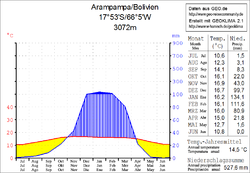
 Climate diagram Arampampa |
||
Arampampa is a town in the Potosí department in the South American Andean state of Bolivia .
Location in the vicinity
Arampampa is the capital of the province of Bernardino Bilbao and the central place of the district ( Bolivian : Municipio ) Arampampa . It is located on a fertile plateau at an altitude of 3,072 m , three kilometers north of the Río Kicha Kicha , which flows ten kilometers below the city into the Río Caine , the upper reaches of the Bolivian Río Grande .
geography
Arampampa is located in the Bolivian Cordillera Central in the transition area to the Bolivian lowlands. The region's climate is typical of the time of day , with the mean temperature fluctuation during the day being more pronounced than during the seasons.
The mean average temperature of the region is around 14-15 ° C (see climate diagram Arampampa) and fluctuates only slightly between just under 11 ° C in June and July and just under 17 ° C in November and December. The annual precipitation is a good 500 mm and has a pronounced dry season from April to October with monthly precipitation of 0 to 20 mm, only in the short humid period from January to February 100 to 140 mm monthly precipitation.
Transport network
Arampampa is poorly located in terms of traffic in the extreme northeast corner of the Potosí department, at a distance of 92 kilometers by road south of the city of Cochabamba , capital of the neighboring department of Cochabamba , and 662 kilometers from the capital of the department Potosí .
From Arapampa, a road connection leads fifteen kilometers into the deeply cut valley of the Río Caine, which flows here in a south-easterly direction into the Bolivian lowlands. At the mouth of the Río Chincari , the road crosses the Río Caine at an altitude of 2300 m , then winds past the town of Izata at more than 3300 m and leads over the town of Tarata to Cochabamba.
In Cochabamba, the Tarata road meets the Ruta 4 highway , which leads 210 kilometers west to Caracollo , where it meets the Ruta 1 north-south highway . From here it is another 360 kilometers on Route 1 in a southerly direction to Potosí.
population
The population of the village has increased by around half in the past two decades:
| year | Residents | source |
|---|---|---|
| 1992 | 449 | census |
| 2001 | 552 | census |
| 2012 | 659 | census |
Sons and daughters of the place
- General Bernardino Bilbao Rioja (1895–1983), namesake of the province, was born in Arampampa.
Individual evidence
- ^ INE - Instituto Nacional de Estadística Bolivia 1992 ( Memento from April 23, 2014 in the Internet Archive )
- ^ INE - Instituto Nacional de Estadística Bolivia 2001 ( Memento from January 2, 2016 in the Internet Archive )
- ^ INE - Instituto Nacional de Estadística Bolivia 2012 ( Memento of July 22, 2011 in the Internet Archive )
Web links
- Relief map of the Cochabamba region 1: 250,000 (PDF; 10.6 MB)
- Municipio Arampampa - Detailed Maps - General Maps No. 51301
- Municipio Arampampa - detailed map and population data (PDF; 460 kB) ( Spanish )
- Department Potosí - social data of the municipalities (PDF; 5.23 MB) ( Spanish )
