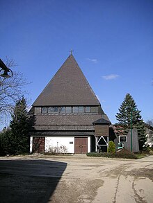
Arnberg am Kobernaußer Walde
|
Arnberg ( village ) locality |
||
|---|---|---|
|
|
||
| Basic data | ||
| Pole. District , state | Ried im Innkreis (RI), Upper Austria | |
| Judicial district | Ried im Innkreis | |
| Pole. local community | Mettmach ( KG Großweiffendorf) | |
| Coordinates | 48 ° 7 '32 " N , 13 ° 20' 20" E | |
| Residents of the village | 117 (January 1, 2020) | |
| Building status | 41 (2011) | |
| Post Code | 4931 | |
| Statistical identification | ||
| Locality code | 10503 | |
| Source: STAT : index of places ; BEV : GEONAM ; DORIS | ||
Arnberg is a village in the Innviertel in Upper Austria and belongs to the municipality of Mettmach in the Ried im Innkreis district . The village has 116 inhabitants (as of 2011) and belongs to the cadastral community of Großweiffendorf . Due to the geographical location (altitude), a community of its own within the municipality of Mettmach formed over time with the villages of Warmanstadl and Jagleck.
geography
The place is about 6 kilometers south of Mettmach and about 18 kilometers southwest of Ried im Innkreis . The place is on the edge of the Kobernaußerwald , in the middle of the so-called Reinthallerholz at an altitude of 645 m .
Due to the extensive settlement and the many wooded areas, Arnberg is the largest place in Mettmach in terms of area.
Neighboring places
| Kleinschnaidt (R) (Gem. Aspach ) (District Braunau ) |
Großweiffendorf (R) | |
| Grubmühl (R) (Gem. St. Johann ) |

|
|
| Geierseck (R) (Gem. St. Johann ) (District Braunau ) |
Jagleck (R) | Warmanstadl (R) |
societies
- Church choir Arnberg
- Arnberg Volunteer Fire Brigade
- Arnberg fraternity
proof
- ↑ Marktgemeinde Mettmach (ed.): Mettmach - Life with Culture , Heimatbuch der Marktgemeinde (2011), pages 88–93. ISBN 978-3-902684-20-2

