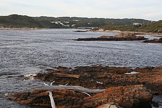
Arthur River (Indian Ocean)
| Arthur River | ||
|
Estuary of the Arthur River |
||
| Data | ||
| location | Tasmania ( Australia ) | |
| River system | Arthur River | |
| Drain over | Arthur River → Indian Ocean | |
| source | at Waratah 41 ° 27 ′ 28 ″ S , 145 ° 29 ′ 25 ″ E |
|
| Source height | 479 m | |
| muzzle | at Arthur River in the Indian Ocean Coordinates: 41 ° 3 ′ 21 " S , 144 ° 39 ′ 36" E 41 ° 3 ′ 21 " S , 144 ° 39 ′ 36" E |
|
| Mouth height | 0 m | |
| Height difference | 479 m | |
| Bottom slope | 2.8 ‰ | |
| length | 172 km | |
| Left tributaries | Keith River , Lyons River , Neasey Creek, Providence Creek, Holder Rivulet, Lawson Rivulet, Rapid River , Julius River , Blackwater Rivulet, Stephens Rivulet, Frankland River | |
| Right tributaries | Waratah River , Deep Gully Creek, Wandle River , Goldfind Creek, Parrawe Creek, Hellyer River , Campbell Rivulet, Cann Creek, Dollie Creek, Boundary Creek, Ekberg Creek, Salmon River , Warra Creek, Sky Creek | |
| Communities | Tayetea Bridge, Kanunnah Bridge, Arthur River | |
The Arthur River is a river in the northwest of the Australian state of Tasmania .
geography
River course
The river has its source around five kilometers west of the small town of Waratah in the northwest part of the island and initially flows in a northerly direction. North of the Savage River National Park , it turns its course to the northwest, runs along the southwest flank of the Campbell Range and then turns west. At Arthur River it flows into the Indian Ocean .
Tributaries with mouth heights
- Waratah River - 317 m
- Deep Gully Creek - 290 m
- Wandle River - 268 m
- Goldfind Creek - 236 m
- Parrawe Creek - 228 m
- Hellyer River - 196 m
- Campbell Rivulet - 179 m
- Keith River - 158 m
- Lyons River - 138 m
- Cann Creek - 138 m
- Neasey Creek - 122 m
- Providence Creek - 103 m
- Holder Rivulet - 96 m
- Dollie Creek - 90 m
- Boundary Creek - 89 m
- Lawson Rivulet - 66 m
- Rapid River - 63 m
- Julius River - 51 m
- Blackwater Rivulet - 34 m
- Stephens Rivulet - 32 m
- Ekberg Creek - 30 m
- Salmon River - 24 m
- Frankland River - 23 m
- Warra Creek - 22 m
- Sky Creek - 16 m
Naming
It is named after Sir George Arthur , who was Governor of Van Diemens Land from 1824-1836 .
economy
The Arthur River area is sparsely populated and was originally used for logging and fishing. Today it is mainly a tourist destination.
On the coast, near the mouth of the Arthur River, there is a sign with a poem by tourism pioneer Brian Inder entitled The Edge of the World. North West Coast Tasmania . Indian refers to the coastline near the town of Arthur River, which is regularly brushed by the storms of the Roaring Forties . On the coast near the mouth of the Arthur River is a plaque titled The Edge of the World. Northwest Coast Tasmania (German: End of the World - Northwest Coast of Tasmania ).
See also
Individual evidence
- ↑ a b c d Map of Arthur River, TAS . Bonzle.com
- ^ Cradle Coast Newsletter. (December 2005). Retrieved October 8, 2008 ( Memento August 2, 2008 in the Internet Archive )
