Auburn, Alabama
|
|
This article was on the basis of substantive defects quality assurance side of the project USA entered. Help bring the quality of this article to an acceptable level and take part in the discussion ! A closer description on the resolving issues is missing. |
| Auburn | |
|---|---|
| Nickname : The Loveliest Village on the Plains | |
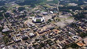
 Aerial view of Auburn University |
|
 seal |
 flag |
| County and state location | |
| Basic data | |
| Foundation : | 1836 |
| State : | United States |
| State : | Alabama |
| County : | Lee County |
| Coordinates : | 32 ° 36 ′ N , 85 ° 29 ′ W |
| Time zone : | Central ( UTC − 6 / −5 ) |
|
Inhabitants : - Metropolitan Area : |
53,380 (as of 2010) 158,991 (as of 2016) |
| Population density : | 382.1 inhabitants per km 2 |
| Area : | 140.8 km 2 (approx. 54 mi 2 ) of which 139.7 km 2 (approx. 54 mi 2 ) are land |
| Height : | 216 m |
| Postcodes : | 36800-36899 |
| Area code : | +1 334 |
| FIPS : | 01-03076 |
| GNIS ID : | 0113277 |
| Website : | www.auburnalabama.org |
| Mayor : | Bill Ham, Jr. |
Auburn is a city in Lee County , in the US state of Alabama , in the United States .
education
The Auburn University with about 24,000 students, the second largest university in Alabama. At Auburn University is the Donald E. Davis Arboretum , an arboretum covering nearly 6 acres.
sons and daughters of the town
- Robert L. Gibbs (* 1971), White House Press Secretary
- Jamie Hampton (born 1990), tennis player
- Aubrey Reese (born 1978), basketball player
- Frederick Chapman Robbins (1916–2003), microbiologist, doctor and Nobel Prize winner
- Lily Ross Taylor (1886–1969), ancient historian
- DeMarcus Ware (born 1982), football player
Important buildings
Partner municipality
Individual evidence
- ↑ Missouri Census Data Center ( page no longer available , search in web archives ) Info: The link was automatically marked as defective. Please check the link according to the instructions and then remove this notice. Retrieved October 12, 2012
Web links
Commons : Auburn, Alabama - Collection of images, videos, and audio files

